Irish Railway System Map 1920 to 2020

Alex Cartwright
Senior Cartographer & GIS Specialist
Alex Cartwright is a renowned cartographer and geographic information systems specialist with over 15 years of experience in spatial analysis and data...
Geographic Analysis
What This Map Shows
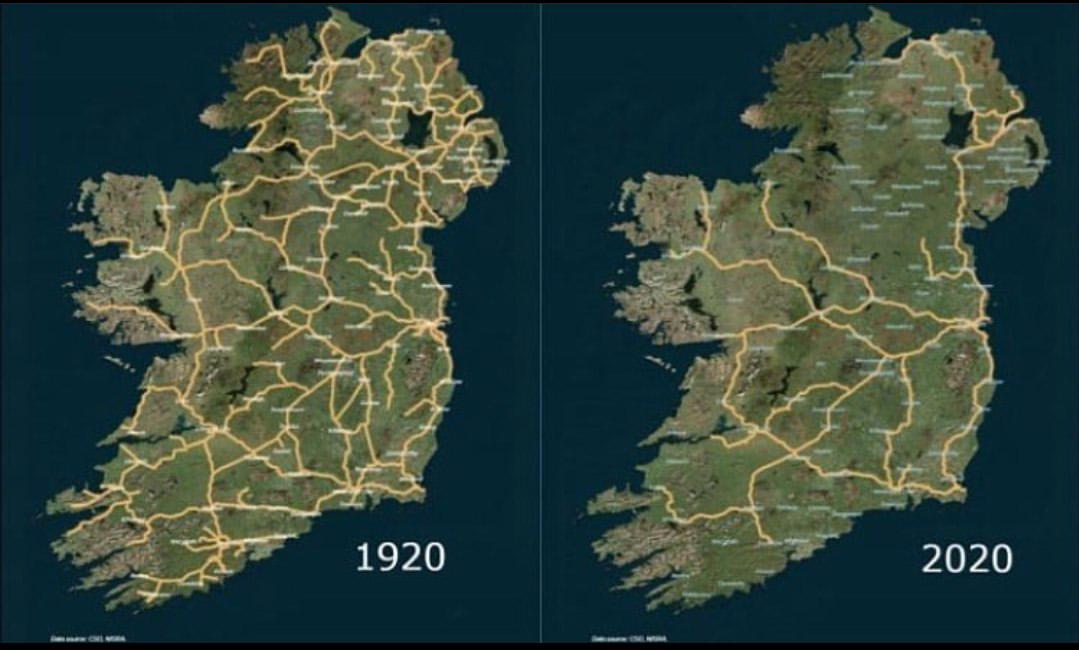
The map titled 'The Irish Railway System between 1920 and 2020' provides a comprehensive visualization of the railway infrastructure across Ireland over a century. It highlights significant changes in the railway network, including expansions, contractions, and key operational lines throughout the years. This timeline allows us to observe the evolution of rail transport in Ireland, reflecting broader socio-economic shifts, technological advancements, and policy decisions that have influenced the nation's connectivity.
Deep Dive into the Irish Railway System
The Irish railway system has a rich history dating back to the 19th century when the first railways began operating in Ireland. By 1920, the network had expanded significantly, connecting major cities like Dublin, Belfast, Cork, and Limerick. Interestingly, this period marked the peak of railway operations in Ireland, where rail travel was a primary mode of transportation for both goods and passengers.
However, as the decades progressed, the railway system faced numerous challenges. The mid-20th century saw a decline in rail usage due to the rise of road transport and private car ownership. This shift had a profound impact on the railway network, leading to the closure of many lines and stations. For instance, the Beeching cuts, which affected railways across the UK, also had rippling effects in Ireland, resulting in the loss of significant routes and services.
By the late 20th century, only a fraction of the original railway lines remained operational. In 2000, the total length of the railway in Ireland had dropped to about 1,200 kilometers, down from over 3,000 kilometers in the 1920s. This reduction is a sobering reminder of the decline in rail infrastructure, where many towns that once thrived on railway connectivity found themselves isolated.
Interestingly, the turn of the 21st century marked a gradual renaissance for the Irish railway system. With increasing awareness of environmental issues and a growing population, rail transport began to regain favor. Investments in the railway infrastructure were made, with electrification projects and new rolling stock coming into play. This modernization aimed to enhance efficiency and attract more passengers back to the rails.
What's fascinating is the combination of heritage and innovation in the current railway system. While preserving historical routes, new lines, such as the Luas tram system in Dublin, illustrate a shift towards integrated public transport solutions. The map serves as a poignant reminder of both the lost glory and the potential revival of rail travel in Ireland.
Regional Analysis
When examining the map by region, significant disparities emerge. In the eastern part of Ireland, particularly around Dublin, the railway system remains relatively robust. The DART (Dublin Area Rapid Transit) service connects the capital with surrounding suburbs, catering to a modern commuter demographic. In fact, ridership has surged in recent years, underscoring the effectiveness of targeted investments in public transport.
Conversely, the western regions, including parts of Connacht, have experienced more pronounced declines in railway services. Towns such as Ballaghaderreen and Westport, once serviced by extensive railway lines, are now left with limited public transport options. This regional disparity raises questions about equity in transport access and its implications for local economies, particularly in more rural areas.
In Northern Ireland, the railway network, operated by Translink, has seen stability and even growth in some areas. The Belfast to Derry line remains a vital connection for both commuters and tourists, showcasing the potential for rail to stimulate regional development.
Significance and Impact
The evolution of the Irish railway system is not just a tale of infrastructure; it’s a narrative that reflects broader societal changes. The decline of rail transport throughout the latter half of the 20th century had significant implications for urban development, economic prosperity, and even environmental policies. As cities expanded and car ownership grew, the reliance on rail diminished, leading to increased traffic congestion and pollution.
However, the renewed interest in rail transport in the 21st century poses an opportunity for sustainable development. As the world grapples with climate change, investing in rail infrastructure is seen as a viable solution to reduce carbon emissions. Future projections suggest that if current trends continue, we may see a further expansion of the Irish railway system, potentially connecting more rural communities and enhancing overall accessibility.
In conclusion, the Irish railway system map from 1920 to 2020 not only tells the story of transportation but also invites us to reflect on our choices and their long-term impacts. It serves as a reminder that while we may have experienced a significant downgrade in railway connectivity, the potential for rebirth and revitalization is very much within our grasp.
Visualization Details
- Published
- August 16, 2025
- Views
- 98
Comments
Loading comments...