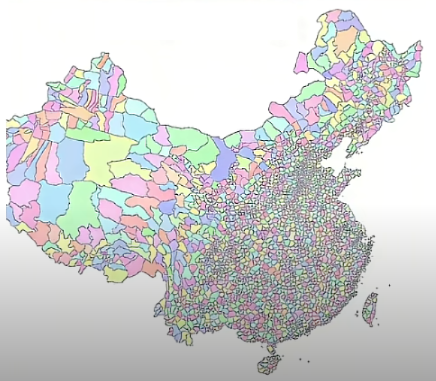
All Counties in China Map

Alex Cartwright
Senior Cartographer & GIS Specialist
Alex Cartwright is a renowned cartographer and geographic information systems specialist with over 15 years of experience in spatial analysis and data...
Geographic Analysis
What This Map Shows
The "All Counties in China Map" provides a comprehensive view of the administrative divisions within the country. It highlights all the counties, which are the primary units of governance in China, showcasing their locations, boundaries, and relative sizes. This visualization is crucial for understanding China's complex administrative framework and its geographical distribution. With 2,862 counties, the map reveals how these areas are spread across different provinces, reflecting the country's vast diversity in culture, economy, and demographics.
Deep Dive into China's County Structure
China's administrative divisions are layered like an onion, with provinces at the top, followed by prefectures, counties, and townships. The significance of counties cannot be overstated; they serve as vital local governance units that manage everything from education to infrastructure. Interestingly, each county may have its own unique characteristics, influenced by factors such as geography, history, and local economy.
Did you know that the majority of China's counties are located in rural areas? In fact, about 50% of the population lives in these counties, which often serve as the backbone of agricultural production. This is where the majority of China's rice, wheat, and corn are cultivated, contributing significantly to food security.
In terms of demographics, counties vary widely. For instance, the population density in counties near major cities like Beijing or Shanghai can exceed 1,000 people per square kilometer, while remote counties in the western regions, such as Tibet and Xinjiang, may have densities as low as 10 people per square kilometer. This stark contrast highlights the urban-rural divide in China, with cities attracting a significant migration of people seeking better opportunities.
Moreover, economic activities differ substantially from one county to another. Coastal counties, such as those in Guangdong province, are often more industrialized and economically vibrant compared to inland counties, which may rely heavily on agriculture. This economic disparity can lead to uneven development, prompting government initiatives aimed at promoting rural revitalization and reducing poverty.
Regional Analysis
When examining the map, we can categorize the counties into distinct regions: Eastern, Central, Western, and Northern China. Each region presents its own unique traits. For example, counties in Eastern China, including Jiangsu and Zhejiang, are typically more developed due to their proximity to the coast and major trade routes. Here, urbanization rates are high, and the economy is driven by manufacturing and services.
On the other hand, Central China, which includes provinces like Henan and Hubei, showcases a blend of urban and rural landscapes. These counties often serve as agricultural hubs while also developing industrial bases. Interestingly, Henan is the most populous province in China, with a significant number of counties that accommodate a large workforce.
In contrast, Western China, including provinces such as Sichuan and Yunnan, features diverse terrains, from mountains to plateaus. The counties here often face challenges such as underdevelopment and limited access to resources. However, they are rich in cultural diversity, with numerous ethnic groups contributing to the region's unique identity. For instance, Yunnan is home to 25 different ethnic minorities, which enrich the county's cultural tapestry.
Finally, Northern China, including provinces like Shanxi and Inner Mongolia, exhibits a mix of arid landscapes and agricultural land. The counties here are significant for coal production and have been pivotal in China's energy supply.
Significance and Impact
Understanding the counties of China is essential for several reasons. It not only illustrates the country’s administrative framework but also serves as a lens through which we can analyze social and economic trends, development policies, and demographic shifts. The disparities between counties often reflect broader national issues, such as the urban-rural divide and economic inequality.
Interestingly, the Chinese government has been actively promoting initiatives aimed at balancing development across various counties. With the rise of smart cities and digital governance, counties are increasingly adopting technology to improve public services and enhance economic growth. The future projections indicate that as urbanization continues, many rural counties will undergo significant transformations, potentially leading to more integrated and sustainable communities.
In conclusion, the "All Counties in China Map" is more than just a geographical tool; it serves as a critical resource for understanding the complexities of governance, demographics, and economic activities in one of the world's largest countries. Whether you’re a researcher, a student, or simply a geography enthusiast, appreciating the nuances of China’s counties can provide valuable insights into its past, present, and future.
Visualization Details
- Published
- August 8, 2025
- Views
- 106
Comments
Loading comments...