Rostov Region Territorial Changes Map 1917-2025

David Chen
Data Visualization Specialist
David Chen is an expert in transforming complex geographic datasets into compelling visual narratives. He combines his background in computer science ...
Geographic Analysis
What This Map Shows
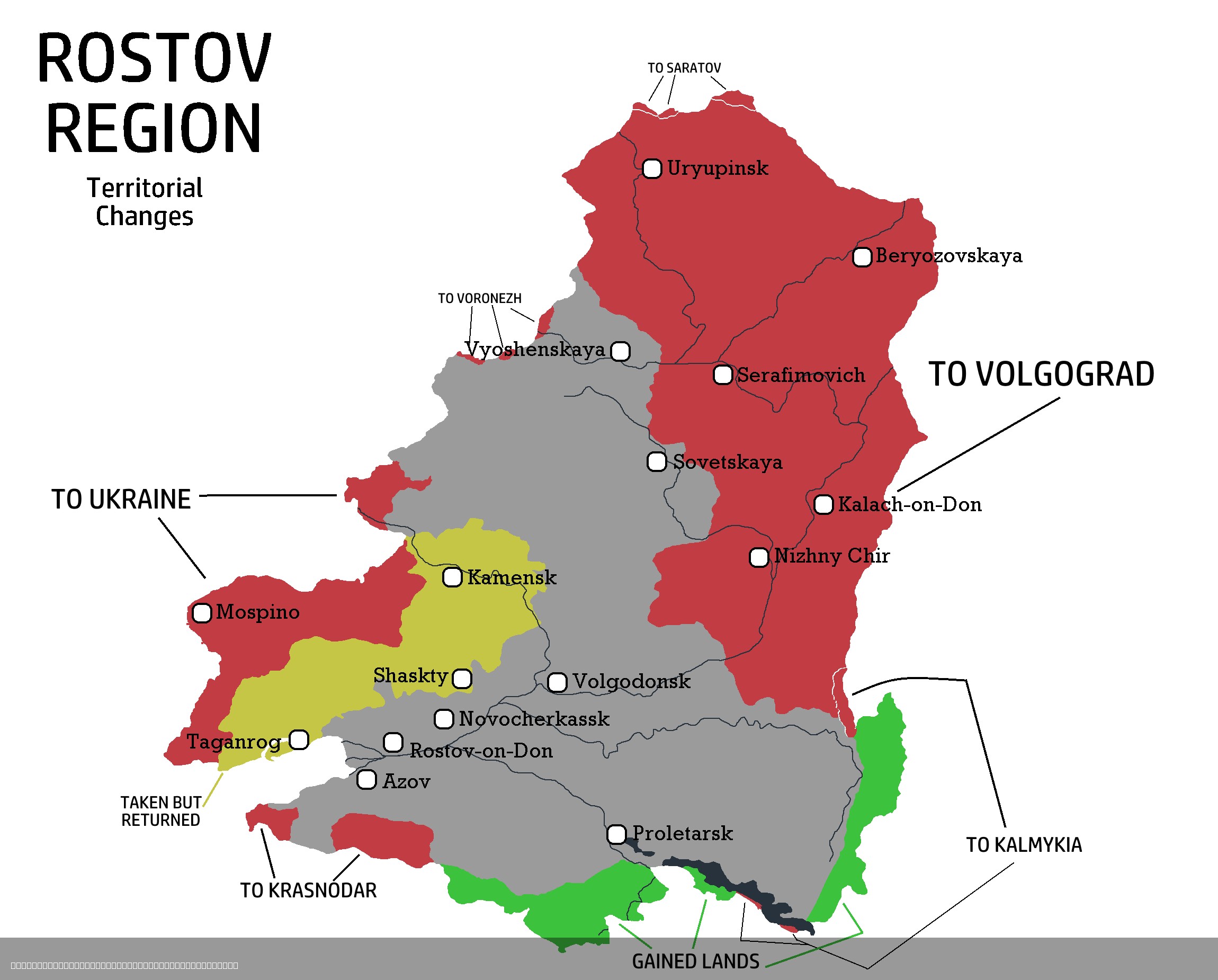
The "Rostov Region Territorial Changes Map 1917-2025" provides a comprehensive visual representation of the territorial adjustments that have occurred in the Rostov Region of Russia over more than a century. This map encapsulates the shifting boundaries, the establishment of administrative divisions, and the evolving geopolitical landscape that has defined this area from the aftermath of the Russian Revolution to the present day. By examining these changes, we can better understand the region's historical context, demographic shifts, and administrative reorganizations that have influenced its development.
Deep Dive into Territorial Changes in the Rostov Region
The Rostov Region, situated in the southern part of Russia, has undergone significant territorial transformations since 1917. Following the Russian Revolution, the newly formed Soviet government initiated a series of administrative reforms that reshaped the political and geographical landscape of the region. Initially part of the Don Cossack Host, the area was restructured into various administrative units, reflecting the broader Soviet policy of reorganizing territories based on political and economic considerations.
One of the most notable changes occurred in the 1930s when the Rostov Region was established as an administrative entity, encompassing several previously independent districts. This consolidation aimed to streamline governance and improve resource management in a region that was rapidly industrializing. Interestingly, the Rostov Region became a significant hub for agriculture and industry, particularly in the cultivation of grain and livestock farming, which remains vital to its economy today.
Throughout the decades, the region experienced further adjustments, especially during the tumultuous periods of World War II and the subsequent recovery. In the post-war era, the map reflects the incorporation of new territories and the restoration of pre-war boundaries, as authorities sought to rebuild and strengthen the economy. The Rostov Region played a critical role in the Soviet Union's agricultural output, and its strategic location along the Don River facilitated trade and transport.
Additionally, the collapse of the Soviet Union in 1991 ushered in another wave of territorial reconfigurations. The map showcases how the Rostov Region adapted to the new political landscape, with an emphasis on establishing local governance structures and enhancing regional identity. The transition to a market economy also prompted shifts in administrative boundaries to accommodate new economic realities and demographic trends.
As we look towards the future, projections suggest that the Rostov Region will continue to evolve, responding to changes in population dynamics, economic development, and environmental challenges. For instance, urban areas like Rostov-on-Don have experienced significant growth, leading to the need for revised administrative frameworks to manage urban expansion and its associated challenges.
Regional Analysis
Examining the Rostov Region's territorial evolution reveals significant disparities across its various administrative divisions. For instance, the urban center of Rostov-on-Don has seen considerable population growth and infrastructural development, contrasting sharply with rural areas that may struggle with depopulation. In the early 2000s, Rostov-on-Don's population was around 1.1 million, making it one of the largest cities in southern Russia. This urbanization trends have necessitated infrastructure improvements and changes in local governance to meet the needs of a growing population.
Conversely, regions such as the southeastern parts of the Rostov Region have experienced slower growth rates. Factors such as limited economic opportunities and migration patterns have contributed to these disparities. Interestingly, the map illustrates how administrative borders sometimes fail to align with economic realities, leading to discussions on whether further reorganizations are necessary to promote balanced regional development.
Significance and Impact
Understanding the territorial changes in the Rostov Region is crucial for several reasons. Firstly, it provides insight into the historical and political factors that have shaped the area, highlighting the impact of broader historical events on local governance and demographics. Secondly, these changes reflect ongoing trends that affect not only the Rostov Region but also the wider Southern Federal District of Russia.
As the region faces contemporary challenges such as economic diversification, population aging, and environmental sustainability, the significance of understanding its territorial changes becomes even more apparent. The current trajectory indicates that Rostov will continue to play a pivotal role in regional and national contexts, especially in agriculture and industry.
In conclusion, the "Rostov Region Territorial Changes Map 1917-2025" serves as a vital tool for historians, geographers, and policy-makers alike. By analyzing the map's details, one can glean valuable insights into the socio-political fabric of this dynamic region, providing a foundation for informed discussions about its future.
Visualization Details
- Published
- August 7, 2025
- Views
- 122
Comments
Loading comments...