Territorial Organization of the Late Roman Empire Map

Alex Cartwright
Senior Cartographer & GIS Specialist
Alex Cartwright is a renowned cartographer and geographic information systems specialist with over 15 years of experience in spatial analysis and data...
Geographic Analysis
What This Map Shows
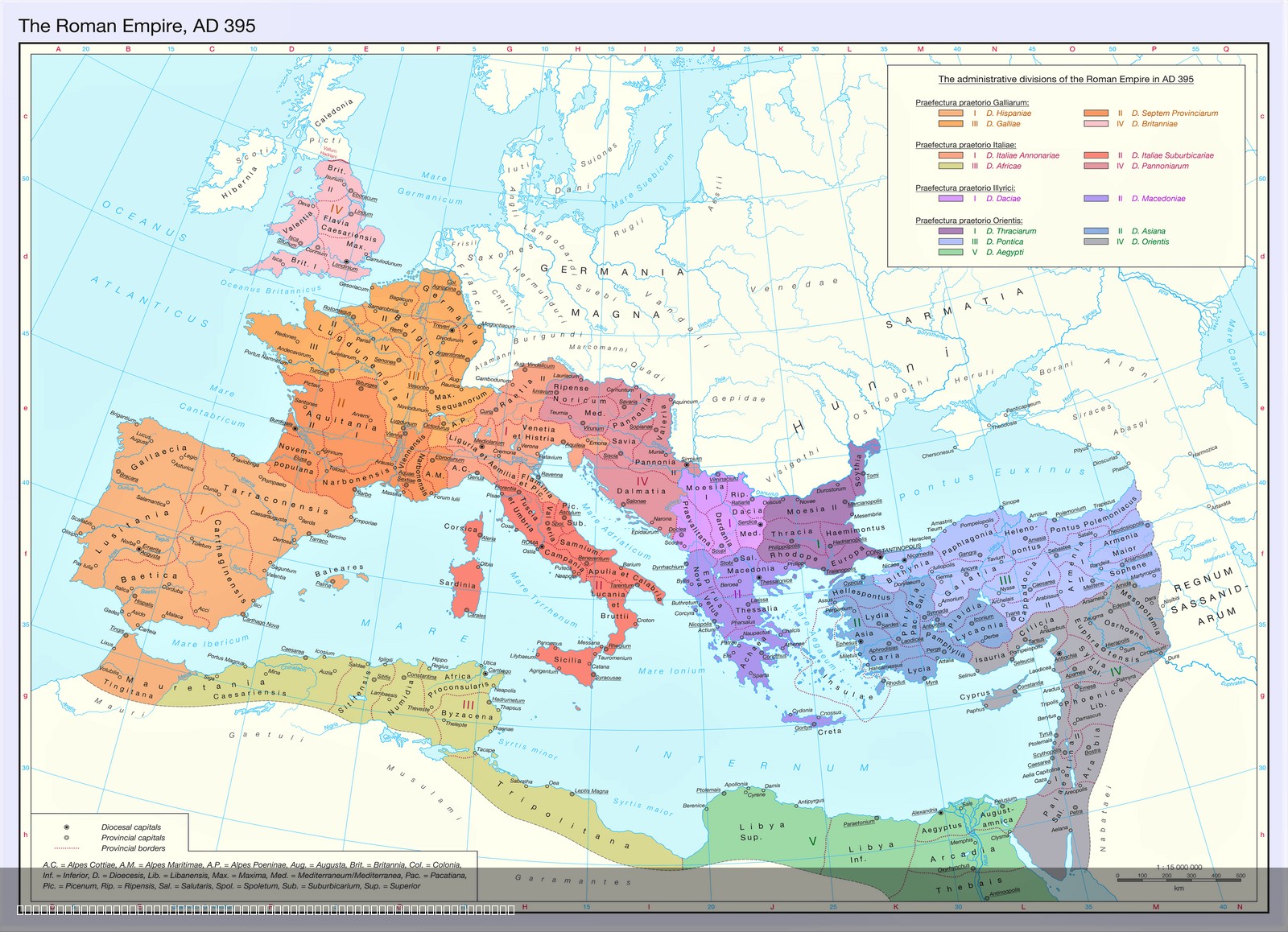
The map titled "The Territorial Organization of the Late Roman Empire (395 AD)" provides a detailed visualization of the dioceses and provinces that comprised the Roman Empire during its twilight years. The distinct colors representing the various dioceses illustrate the administrative divisions that were established to manage the vast territories under Roman control. Each province, denoted as a second-level subdivision, showcases how the empire was organized for taxation, governance, and military purposes. This visual representation is essential for understanding the complex administrative structure that helped maintain Roman authority over diverse populations across Europe, North Africa, and parts of Asia.
Deep Dive into the Late Roman Empire's Administrative Structure
The late Roman Empire, particularly around 395 AD, was a vast and sprawling entity, characterized by its intricate administrative divisions. The divisional structure of dioceses and provinces was not merely a bureaucratic formality; it served crucial functions in governance, military organization, and resource management. The Roman Empire was divided into provinces, each governed by officials appointed by the emperor. These provinces were further grouped into larger dioceses, which consolidated administrative responsibilities and provided a more manageable framework for governance across extensive territories.
Interestingly, the establishment of dioceses was a strategic move by Emperor Diocletian in the late 3rd century as part of his reforms aimed at stabilizing the empire. By 395 AD, under Emperor Theodosius I, the division into dioceses had become a standard practice. Each diocese, such as the Diocese of Italy or the Diocese of Africa, included multiple provinces that allowed for localized governance, facilitating better control over resources, military recruitment, and taxation.
The provinces themselves varied significantly in size and significance. For instance, provinces like Gaul and Britannia were crucial for their military contributions, while regions such as Egypt were vital for grain production, crucial for feeding the empire. This centralized approach to administration enabled Rome to manage its diverse populations, each with their unique cultures, languages, and customs. As a result, the late Roman Empire was able to maintain a degree of unity and stability despite the challenges posed by external invasions and internal strife.
Moreover, the map illustrates how the Roman Empire was not monolithic but rather a mosaic of cultures and societies. Each province had its own local governance structures, laws, and traditions, which were often influenced by the pre-existing cultures of the conquered peoples. For example, the provinces in North Africa were heavily influenced by Berber and Phoenician cultures, while those in the eastern regions echoed Hellenistic traditions. This blend of local customs with Roman administration is a fascinating aspect of the empire's enduring legacy.
Regional Analysis
Analyzing the map reveals distinct regional characteristics within the late Roman Empire. The western provinces, such as Hispania and Gallia, were known for their agricultural productivity and military strength. They were crucial in providing troops for the Roman legions and food for the empire's urban centers.
In contrast, the eastern provinces, including Asia Minor and the Levant, were centers of trade and commerce. These regions served as vital economic hubs that connected the empire with the lucrative trade routes of the east, particularly in spices, silks, and other luxury goods. The province of Egypt stood out as the breadbasket of the empire, supplying grain to Rome and serving as a critical economic asset.
Interestingly, the provinces of the Balkans, such as Moesia and Thracia, presented a unique blend of military and cultural significance. They acted as a buffer zone against invasions from the north, particularly from Germanic tribes, while also being influenced by both Greek and Roman cultures. This cultural interplay is evident in archaeological findings and historical records from the period.
Significance and Impact
Understanding the territorial organization of the late Roman Empire is crucial for several reasons. Firstly, it sheds light on the administrative ingenuity that allowed Rome to govern a vast and diverse empire effectively. This organizational model influenced future empires and nations in their governance structures, demonstrating the importance of local administration in maintaining control.
Moreover, the implications of such an organization extend to the present day. By studying the administrative divisions of the Roman Empire, we can better appreciate the historical context of modern European borders and the lingering effects of Roman governance on contemporary political structures. As nations continue to grapple with issues of regional autonomy and governance, the lessons from the Roman administrative system remain relevant.
In conclusion, the map of the late Roman Empire’s territorial organization not only illustrates the empire’s vastness but also highlights the sophisticated methods of governance that allowed it to thrive for centuries, laying the foundation for many aspects of modern governance and regional identity today. Understanding this administrative legacy gives us a deeper appreciation of how historical frameworks continue to shape our world.
Visualization Details
- Published
- August 7, 2025
- Views
- 156
Comments
Loading comments...