Southern California Urban Nightscape Map

Marcus Rodriguez
Historical Geography Expert
Marcus Rodriguez specializes in historical cartography and geographic data analysis. With a background in both history and geography, he brings unique...
Geographic Analysis
What This Map Shows
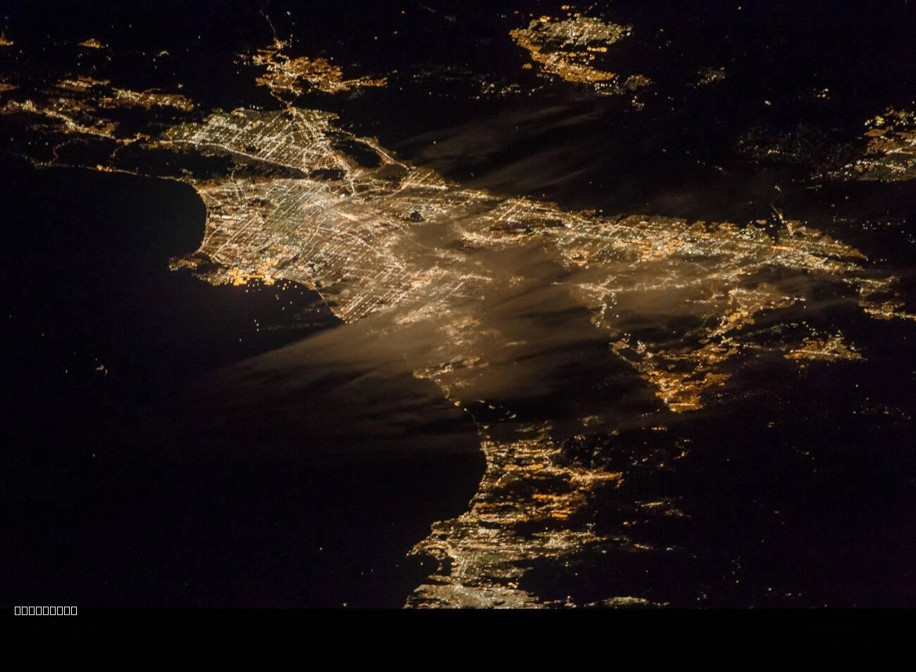
The "Urban Expanse of Southern California at Night" map showcases the sprawling metropolitan areas of Southern California illuminated after sunset. This visualization captures not just the sheer size of urban development but also highlights how different regions light up, indicating areas of high population density, commercial activity, and infrastructural development. The bright patches reveal where the most vibrant urban life is concentrated, from the bustling streets of Los Angeles to the quieter suburbs of Orange County.
Deep Dive into Urban Development in Southern California
Southern California is an intriguing case study when examining urban development, particularly at night. The area is characterized by its unique blend of urban and natural landscapes. The map serves as a powerful testament to the extensive urbanization that has taken place over the last few decades. From the iconic skyline of downtown Los Angeles to the sprawling suburbs of San Diego, the region reflects a complex interplay between population growth, economic opportunities, and cultural diversity.
Interestingly, the bright spots on the map correspond to major urban centers where economic activity thrives. For instance, Los Angeles is not only the entertainment capital of the world but also a significant hub for technology, trade, and tourism. The city's dense concentration of bright lights denotes areas where businesses operate late into the night, including restaurants, theaters, and nightclubs.
The nighttime illumination also reveals the extensive freeway systems that connect various cities and neighborhoods across the region. Southern California is known for its car culture, and the network of highways is vital for commuting. The map illustrates how these roadways are arteries of activity, bustling with vehicles even after dark.
Moreover, the map highlights the importance of public transit developments in urban planning. Areas with significant public transportation infrastructure tend to have more consistent lighting patterns, suggesting higher nighttime foot traffic. For example, the Metro system in Los Angeles and the light rail in San Diego provide essential services that enable residents to navigate the city even during late hours.
In contrast, the dimmer areas on the map often correspond to regions with lower population density or less economic activity. Rural communities or neighborhoods that are less developed may not exhibit the same vibrant glow, underscoring the disparities in urbanization across the region. This raises questions about access to resources, economic opportunities, and community services in these less illuminated areas.
Regional Analysis
When breaking down the map by regions, it’s clear that Southern California is a mosaic of urban experiences. For example, Los Angeles County, with its dense population and numerous commercial hubs, outshines many other areas in terms of nighttime illumination. The downtown area, known for its skyscrapers and nightlife, is a stark contrast to the less populated, suburban areas of Riverside and San Bernardino counties, which exhibit much dimmer light patterns.
Orange County presents an interesting case. Cities like Irvine and Anaheim are lit up significantly due to their blend of residential and commercial spaces, with family-friendly attractions like Disneyland contributing to the nighttime glow. Conversely, areas such as parts of San Bernardino County are less illuminated, highlighting the socioeconomic divides that exist within Southern California.
Furthermore, the Coastal areas, particularly around Santa Monica and Malibu, show a unique profile with a balance of residential lighting and natural preservation that creates a different ambiance compared to the bustling urban centers. Despite their proximity to major cities, these coastal regions maintain a sense of tranquility, especially during nighttime.
Significance and Impact
Understanding the urban expanse of Southern California, especially at night, is critical for policymakers, urban planners, and residents alike. The patterns of light not only reflect where people live and work but also indicate the health of local economies. With urbanization continuing to rise, analyzing these patterns can lead to informed decisions on infrastructure development, community services, and environmental preservation.
Moreover, as we face challenges like climate change and housing shortages, recognizing the implications of urban sprawl and the distribution of resources becomes increasingly important. Trends suggest that urban areas will continue to grow, leading to further demands on infrastructure and public services.
In conclusion, the "Urban Expanse of Southern California at Night" map serves as more than just a visual representation of where people reside; it is a reflection of the multifaceted dynamics at play in one of the most populous regions in the United States. As we continue to navigate the complexities of urban life, this map offers valuable insights that can guide future developments and community planning efforts.
Visualization Details
- Published
- August 6, 2025
- Views
- 112
Comments
Loading comments...