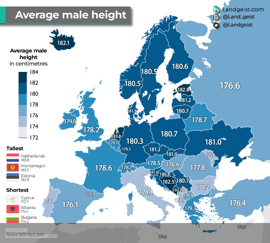
Real Height Map of Europe


David Chen
Data Visualization Specialist
David Chen is an expert in transforming complex geographic datasets into compelling visual narratives. He combines his background in computer science ...
Geographic Analysis
What This Map Shows
The "Real Height Map of Europe" provides a striking visual representation of the varying elevations across the continent. By highlighting the actual heights of terrains, it allows viewers to grasp the geographical diversity that defines Europe. The map emphasizes how some regions host towering mountain ranges, while others showcase vast plains and rolling hills. With this visualization, we can delve into how elevation impacts not only the landscape but also the climate, biodiversity, and human activity across Europe.
Deep Dive into European Elevation
Ever wondered how elevation shapes a continent? In Europe, the variation in height is quite remarkable. The landscape is dominated by several prominent mountain ranges, including the Alps, the Pyrenees, and the Carpathians. The Alps, which stretch across eight countries, are the highest mountain range in Europe, with Mont Blanc standing at 4,808 meters (15,774 feet) in France. This elevation creates distinct climatic conditions, leading to cold winters and mild summers, which greatly influence agriculture and tourism in the region.
Conversely, much of Northern Europe features lower elevations, with countries like the Netherlands and Denmark being predominantly flat. The lowest point in Europe is located in the Netherlands, where the Zuidplaspolder sits approximately 6.7 meters (22 feet) below sea level. This stark difference in elevation raises interesting questions about how these regions adapt to their specific geographical challenges.
Interestingly, elevation affects more than just the physical landscape; it also influences biodiversity. Mountainous regions, for instance, are often home to unique flora and fauna that have adapted to the altitude. The Alpine region boasts a variety of species, many of which are endemic and not found elsewhere in Europe. Meanwhile, lowland areas typically support different ecosystems, favoring agricultural practices over wilderness.
The relationship between elevation and population density is another fascinating aspect to consider. Urban centers often develop in lowland areas due to easier access to resources, trade routes, and agricultural land. For example, cities like Paris and Amsterdam thrive in these flat terrains, while the mountainous regions may be less populated but attract tourists eager to explore the natural beauty.
Regional Analysis
When examining the height map of Europe, distinct regional patterns emerge. In Southern Europe, the rugged terrain of the Alps and Apennines defines the landscape, while countries like Spain showcase the Sierra Nevada and the Pyrenees. The elevation in these areas not only contributes to striking vistas but also influences local cultures and economies, particularly through tourism and winter sports.
In contrast, Central and Eastern Europe include a mix of rolling hills and plateaus, such as the Czech Highlands and the Carpathians, where peaks rise modestly but are crucial for water resources. The rivers originating from these mountains, like the Danube and Vistula, serve as vital waterways for trade and transport across the continent.
Moving to Northern Europe, the Scandinavian Mountains dominate Norway and Sweden, offering stunning fjords and rich ecosystems. The population density here is relatively low, largely due to the harsh climate and rugged terrain. However, cities like Oslo and Stockholm showcase how urbanization can adapt to these geographical constraints.
Significance and Impact
Understanding the elevation across Europe is crucial for various reasons. For one, it plays a significant role in climate patterns, influencing everything from rainfall distribution to temperature variations. As climate change continues to be a pressing global issue, regions with higher elevations may experience different impacts compared to lowland areas. For instance, melting glaciers in the Alps can lead to rising sea levels, which in turn affects coastal cities.
Moreover, elevation has a direct effect on agriculture. Farmers in mountainous regions must contend with shorter growing seasons and different crop choices compared to those in lowland areas. As global warming progresses, shifts in agricultural zones may occur, requiring farmers to adapt to new conditions.
In conclusion, the "Real Height Map of Europe" is more than just a visualization of elevation; it is a gateway to understanding how geography shapes life across the continent. From climate and biodiversity to urban development and agricultural practices, elevation plays an integral role in the story of Europe.
Comments
Loading comments...