2025 South Korea Presidential Election Map

Alex Cartwright
Senior Cartographer & GIS Specialist
Alex Cartwright is a renowned cartographer and geographic information systems specialist with over 15 years of experience in spatial analysis and data...
Geographic Analysis
What This Map Shows
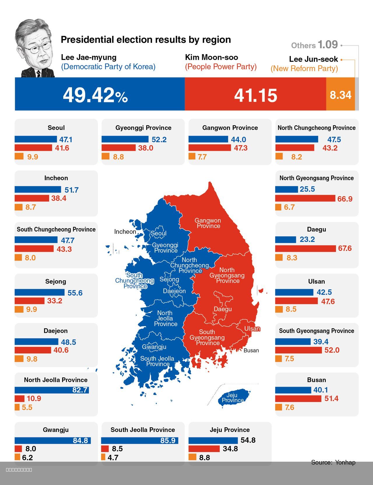
The 2025 South Korea Presidential Election Map illustrates the election results, focusing on the stark contrast between the western and eastern regions of the country. This visualization provides a clear overview of the political divide, showcasing how different areas voted in the election. The map highlights not only the winning candidates but also the demographic and cultural factors that influence voting behaviors across regions.
Deep Dive into South Korean Political Geography
South Korea's political landscape is shaped by a variety of historical, cultural, and socioeconomic factors. The country is often divided into two distinct regions: the western areas, including Seoul and Incheon, and the eastern regions, encompassing cities like Busan and Ulsan. The western regions tend to lean more liberal and progressive, while the eastern parts are generally known for their conservative voting patterns.
Interestingly, this divide isn't just a recent phenomenon; it has roots in historical contexts, such as the Korean War and subsequent developments. For instance, after the war, major urbanization occurred in the west, leading to a concentration of wealth and educational opportunities there. This urban-centric growth influenced political ideologies, making the west more progressive over time. In contrast, the eastern regions, which are more rural and have a stronger presence of traditional industries, have retained conservative values.
The demographic composition plays a critical role as well. The western cities boast a younger, more diverse population with higher levels of education, which correlates with progressive political views. According to recent statistics, over 70% of voters in metropolitan areas like Seoul identified with liberal parties. In contrast, eastern regions, where older generations predominate, reflect more conservative tendencies, with significant support for right-leaning candidates.
Moreover, economic factors cannot be overlooked. The western regions are home to major corporations and tech industries, creating prosperity and a progressive outlook among the populace. Conversely, the eastern areas, often reliant on manufacturing and traditional sectors, have faced economic challenges, further entrenching conservative views focused on stability and traditional values.
Regional Analysis
Breaking down the results by region reveals some intriguing contrasts. For example, in Seoul, the capital, the liberal candidate garnered nearly 65% of the vote, reflecting the city's youthful, educated demographic. The district of Gangnam, known for its affluent residents, also overwhelmingly supported the progressive candidate, showcasing the influence of socioeconomic status on political preferences.
In contrast, when looking at the southeastern coastal city of Busan, the conservative candidate won with approximately 58% of the vote. This area, characterized by a strong sense of local identity and traditional values, demonstrates how regional pride impacts political choices. Moreover, rural areas in Gyeongsangnam-do, another eastern province, tend to have even stronger support for conservative parties, emphasizing the divide that persists even within the eastern region itself.
Interestingly, some areas, like Jeonju and Gwangju, have shown mixed results, indicating that factors such as local governance and community issues can sway votes in unexpected ways. These cities' unique historical and cultural contexts contribute to a more nuanced political landscape, demonstrating that generalizations about western and eastern voting patterns may not always hold true.
Significance and Impact
Understanding the political geography of South Korea is crucial not only for grasping the current electoral landscape but also for anticipating future trends. The divide between the west and east reflects broader societal issues, including economic disparities, educational inequalities, and regional identities. As South Korea continues to evolve, this map serves as a vital tool for analyzing how these factors will shape future elections.
What’s fascinating is that this political geography could influence not only domestic policies but also international relations. With the rapid changes in global politics, South Korea's stance on issues like North Korea, trade, and environmental policies might pivot depending on which region holds more political power in upcoming elections.
Ultimately, the 2025 South Korea Presidential Election Map is more than just a representation of voting patterns; it encapsulates the intricate web of history, culture, and economics that defines South Korea today. As we look ahead, observing how these dynamics shift will be essential in understanding the country's future direction and its role on the global stage.
Visualization Details
- Published
- August 3, 2025
- Views
- 112
Comments
Loading comments...