Geopolitical Map of Europe 1588

Alex Cartwright
Senior Cartographer & GIS Specialist
Alex Cartwright is a renowned cartographer and geographic information systems specialist with over 15 years of experience in spatial analysis and data...
Geographic Analysis
What This Map Shows
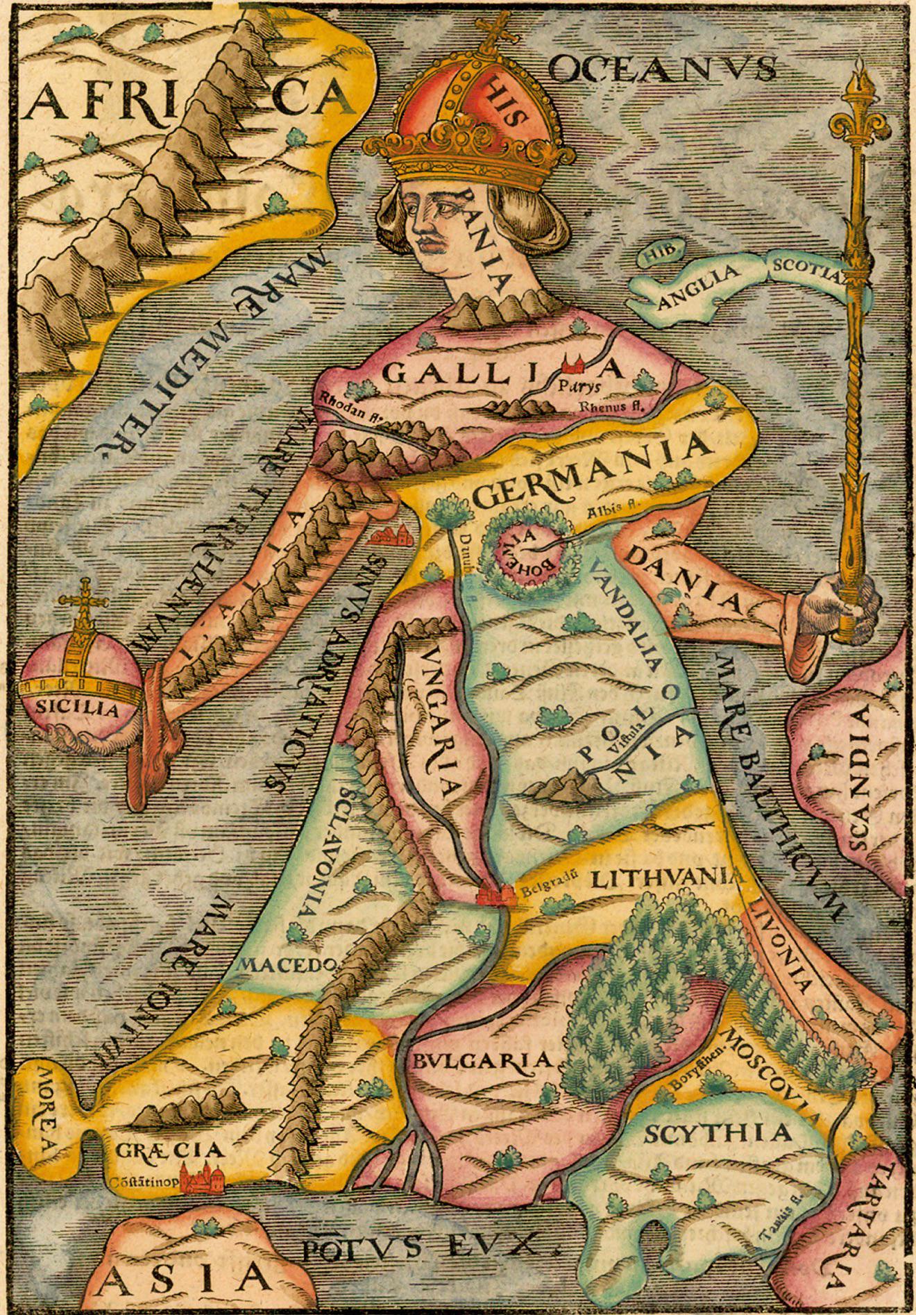
The "Europa Regina" map from the 1588 edition of Cosmographia presents a unique depiction of Europe during a transformative period in history. This map illustrates not only the physical geography but also the political and cultural landscape of the continent at the end of the 16th century. It showcases various kingdoms and territories, emphasizing their borders, capitals, and notable features. The artistic representation of Europe as a queen is emblematic of the era's view of power and influence, encapsulating the complex relationships between nations, cultures, and the burgeoning empires of the time.
Deep Dive into European Geopolitics in 1588
During the late 16th century, Europe was a tapestry of emerging nation-states, tribal territories, and powerful empires. The map serves as a historical snapshot, highlighting the geopolitical rivalries and alliances that defined the era. In 1588, Europe was on the brink of significant changes, including the Protestant Reformation's aftermath and the onset of the Age of Exploration.
The geopolitical landscape was dominated by several key players. Spain, under King Philip II, was a formidable force, boasting vast territories in the Americas and a strong naval presence. The Spanish Armada, famously launched in 1588, aimed to invade England, marking a pivotal moment in European history. Interestingly, the map illustrates Spain's expansive reach, including its possession of the Netherlands and parts of Italy, reflecting its influence over trade routes and colonies.
Conversely, England, led by Queen Elizabeth I, emerged as a central figure in the political drama. The defeat of the Spanish Armada was not only a military triumph but also a significant turning point that fostered English nationalism and maritime power. As depicted on the map, England's territorial integrity and emerging identity were crucial during this period of religious and political turbulence.
France, another major power at the time, was embroiled in the Wars of Religion, which pitted Catholics against Protestants. The map's delineation of territories reveals the fragmentation within France, with regions such as Brittany and Provence illustrating the complexity of its internal conflicts. This internal strife would eventually lead to the rise of absolutism under Louis XIV in the subsequent century.
Moreover, the Holy Roman Empire, a loose confederation of territories under the nominal rule of the Emperor, is depicted with varied principalities and duchies. The political fragmentation within this empire often led to competing interests, making it difficult for any centralized authority to exert control. This division is significant when considering the influence of the Reformation, which had fragmented the religious unity of Europe and contributed to the geopolitical tensions.
Interestingly, the map also highlights the presence of smaller states, such as the city-states of Italy and the principalities of the Holy Roman Empire, which played crucial roles in trade and cultural exchange. The Renaissance had fostered a vibrant culture in these regions, contributing to advancements in art, science, and diplomacy.
Regional Analysis
When examining the map regionally, several distinct geopolitical trends emerge. In the Iberian Peninsula, Spain and Portugal dominated trade and exploration, with Spain's influence extending to the Americas. The map reflects Spain's strategic positioning in relation to the Mediterranean Sea, emphasizing its control over key maritime routes.
In Northern Europe, the map portrays a landscape of conflict and rivalry, particularly between England and France. The English Channel serves as a geographical divide that not only separates these nations but also symbolizes their ongoing tensions. The map's details allow us to explore how geographical features influenced political boundaries and military strategies.
Central Europe, represented by the Holy Roman Empire, showcases a patchwork of territories with varying degrees of autonomy. This complexity highlights the challenges of governance and the impact of local allegiances that often overshadowed central authority. The fragmentation within this region would later play a significant role in the Thirty Years' War.
In Eastern Europe, the map hints at the rising power of the Ottoman Empire, which, although not the primary focus of the map, was expanding its influence northward. The presence of the Ottomans in Eastern Europe would foreshadow future conflicts and shifts in power dynamics.
Significance and Impact
The geopolitical landscape depicted in the "Europa Regina" map is not merely a historical curiosity; it reflects the complexities of power, religion, and culture that shaped European history. Understanding this era is essential for grasping the roots of modern Europe and its borders. The rivalries and alliances of the 16th century set the stage for centuries of conflict, colonialism, and cultural exchange.
Moreover, the implications of the geopolitical dynamics of 1588 resonate today. The historical context of nation-states evolving from feudal territories can be seen in contemporary European politics, where national identities still play a significant role in regional relations. Have you noticed how historical conflicts often shape modern borders and alliances?
As we analyze current trends, such as the rise of nationalism and regional autonomy movements, the lessons from the 1588 map remind us that geography and politics remain inextricably linked. The past informs the present, and understanding the dynamics of early modern Europe can help us navigate today's complex geopolitical landscape.
Overall, the "Europa Regina" map is a valuable artifact that offers insights into a pivotal moment in European history, serving as a reminder of how geography, politics, and culture intertwine to shape our world.
Visualization Details
- Published
- October 30, 2025
- Views
- 6
Comments
Loading comments...