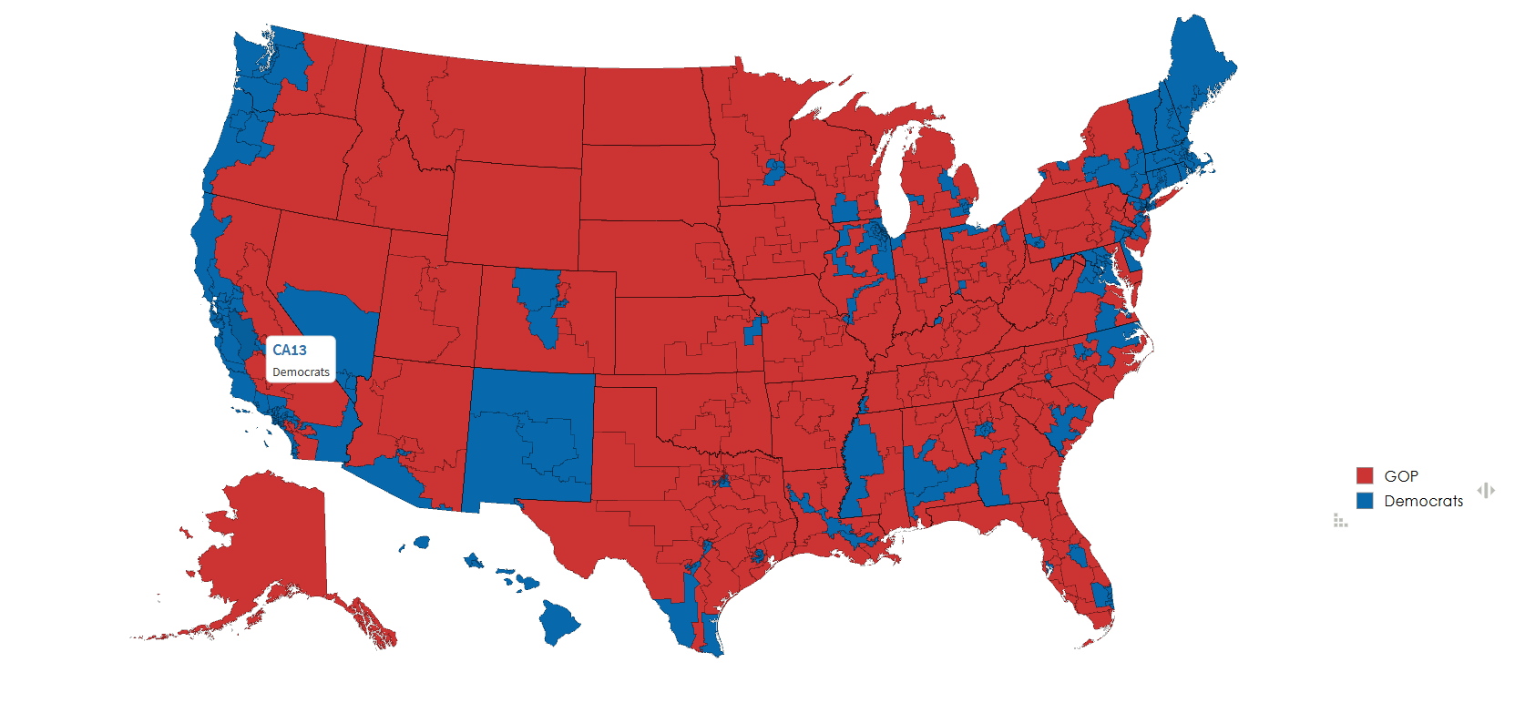
Current House of Representatives Map

Marcus Rodriguez
Historical Geography Expert
Marcus Rodriguez specializes in historical cartography and geographic data analysis. With a background in both history and geography, he brings unique...
Geographic Analysis
What This Map Shows
The "Current House of Representatives Map" provides a visual representation of the political landscape in the United States, illustrating the distribution of congressional districts across the country. Each district is delineated by state boundaries and is color-coded to reflect the political party of the elected representative. This map is an essential tool for understanding the dynamics of political representation and the geographical implications of electoral outcomes.
Deep Dive into Congressional Districts
Congressional districts are critical to the functioning of the U.S. democracy, as they determine how representation is allocated in the House of Representatives. Each district elects one representative, making these boundaries crucial in reflecting the political will of the populace. The total number of districts is capped at 435, a number that has remained constant since 1911, despite the population growth and shifts that have occurred since then.
Interestingly, the process of drawing these districts, known as redistricting, occurs every ten years following the census. This process can lead to significant changes in political power dynamics, especially in states that experience shifts in population. Have you noticed how certain states gain or lose representatives after each census? For example, states like Texas have gained additional seats due to population growth, while others like California have seen a decrease.
The significance of districting extends beyond mere numbers; it also involves socio-political implications. The way districts are drawn can lead to gerrymandering, a practice where boundaries are manipulated to favor one party over another. This can undermine the principles of fair representation and lead to significant disparities in political power. For instance, a party might draw district lines to include more voters who support them, effectively diluting the votes of opposition supporters.
Moreover, the demographic composition of each district plays a vital role in determining electoral outcomes. Factors such as race, income, education level, and urban vs. rural classification can influence voting patterns. Understanding these demographics helps in predicting electoral trends and assessing how various groups are represented in Congress. For example, districts with a higher concentration of young, urban voters may lean more Democratic, while rural districts often lean Republican.
Regional Analysis
Breaking down the map regionally reveals fascinating insights into the political landscape of the United States. In the Northeast, states like New York and Massachusetts have a strong Democratic majority, while areas in the Southeast, such as Alabama and Louisiana, tend to be dominated by Republican representatives. Interestingly, the Midwest presents a mixed picture, with states like Ohio showing both Democratic and Republican strongholds.
If we look at the West Coast, California stands out with a significant number of Democratic representatives, influenced by its large urban centers like Los Angeles and San Francisco. In contrast, states like Idaho and Wyoming in the Northwest are predominantly Republican, showcasing the stark political divides that exist across the country.
Additionally, swing states such as Florida and Pennsylvania are critical in national elections. They often have a mix of both party representatives, reflecting the competitive nature of their electoral landscape. The significance of these regions cannot be overstated, as they often determine the balance of power in Congress.
Significance and Impact
Understanding the current House of Representatives and the accompanying map is crucial for grasping the broader implications of U.S. governance. The composition of the House affects legislation on vital issues such as healthcare, education, and infrastructure. As political parties push their agendas, the representation within the House can lead to significant shifts in policy direction.
Moreover, the ongoing debates around redistricting and gerrymandering highlight the importance of fair representation. With the 2020 Census and the subsequent redistricting cycle, these discussions have become even more relevant. Activism around these issues is growing, with many advocating for independent commissions to oversee the redistricting process and prevent partisan manipulation.
As we look toward the future, it’s essential to monitor how demographic changes and urbanization will continue to shape congressional districts. The increasing diversity of the American population suggests that the political landscape may undergo further transformations in the coming years. What’s fascinating is how these changes will impact not just local elections, but also national politics as a whole. The current House of Representatives map is not just a snapshot of today’s political climate; it’s a reflection of the evolving American identity and its implications for governance.
Visualization Details
- Published
- October 26, 2025
- Views
- 12
Comments
Loading comments...