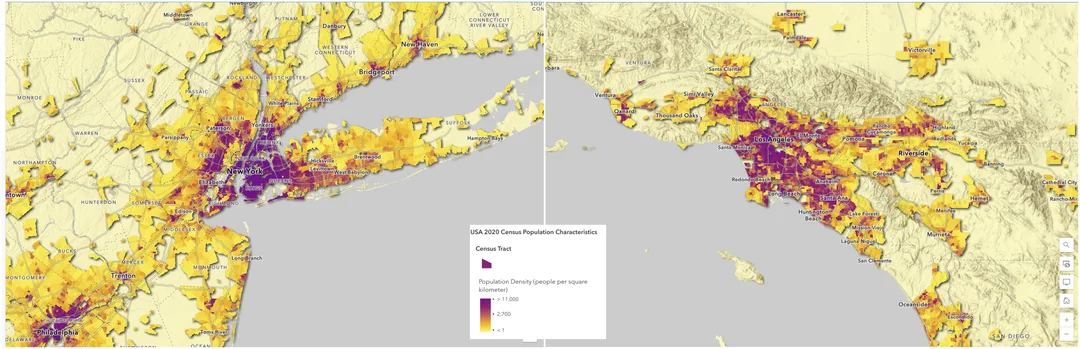
Urban Sprawl Map of New York City and Los Angeles

Alex Cartwright
Senior Cartographer & GIS Specialist
Alex Cartwright is a renowned cartographer and geographic information systems specialist with over 15 years of experience in spatial analysis and data...
Geographic Analysis
What This Map Shows
The "New York City vs. Los Angeles Urban Sprawl" map provides a compelling visual representation of how these two iconic American cities have expanded over time. It highlights the geographical footprint each city occupies and delineates the areas of urban development, illustrating the contrasts in land use, density, and spatial expansion. While New York City is characterized by its vertical skyline and high-density living, Los Angeles sprawls horizontally, encompassing vast suburban areas and diverse landscapes.
Deep Dive into Urban Sprawl
Urban sprawl is a phenomenon that refers to the uncontrolled expansion of urban areas into previously undeveloped land. It's a topic that merits attention, especially in the context of these two major urban centers. New York City, with its rich history and high population density, has developed in a compact manner, where vertical growth has been the hallmark of its urban planning. In contrast, Los Angeles exemplifies a different approach to urban development, marked by extensive low-density residential neighborhoods and a reliance on automobiles for transportation.
Interestingly, urban sprawl in Los Angeles has led to a significant increase in land consumption. According to the U.S. Geological Survey, the metropolitan area of Los Angeles covers around 4,850 square miles, making it one of the largest urban agglomerations in the world. This sprawling nature can be attributed to a combination of factors, including a car-centric culture, the availability of land, and zoning regulations that favor single-family homes.
In contrast, New York City has a land area of approximately 302 square miles, with a population density that is among the highest in the United States, at over 27,000 people per square mile. The city's urban sprawl is constrained by its geography, surrounded by water on three sides and the need to preserve historical neighborhoods. This has resulted in a unique urban fabric where high-rise buildings coexist with parks and public spaces, creating a vibrant, multi-use environment that emphasizes walkability.
Urban sprawl has far-reaching implications, impacting social equity, environmental sustainability, and transportation systems. For instance, the increased reliance on cars in sprawling cities like Los Angeles has resulted in higher greenhouse gas emissions and traffic congestion. Conversely, New York City's dense urban core promotes public transport use, reducing the carbon footprint per capita. Interestingly, research shows that cities that invest in public transit systems often see an increase in economic productivity and quality of life for their residents.
Regional Analysis
When breaking down the map, we can observe distinct patterns of sprawl in both cities. In Los Angeles, areas like the San Fernando Valley and the Inland Empire showcase the extent of suburban growth, with sprawling residential developments and shopping centers. Neighborhoods such as Encino and Santa Clarita are prime examples of how the city has expanded outward, pulling in residents seeking larger homes and more green space.
On the other hand, New York City’s outer boroughs, particularly Queens and Staten Island, exhibit their own forms of sprawl, albeit with a different character. For example, neighborhoods like Bayside in Queens and the suburban-like developments in Staten Island reflect a shift from the dense urban core to areas where single-family homes are more prevalent. However, even in these regions, public transportation remains a vital part of life, keeping residents connected to the bustling city center.
Significance and Impact
Understanding urban sprawl is crucial for urban planners, policymakers, and residents alike. The choices made today regarding land use and development will have lasting effects on community cohesion, environmental sustainability, and economic viability. As cities continue to grow, balancing the need for housing with the preservation of green spaces and the promotion of public transport is essential.
Currently, cities like Los Angeles are facing challenges related to traffic congestion, housing affordability, and environmental degradation, prompting discussions around smarter growth strategies. Meanwhile, New York City is continually grappling with its own issues of housing density and urban infrastructure.
As we look toward the future, the lessons learned from these two cities can guide other urban areas facing similar challenges. Have you ever considered how urban sprawl affects your community? As cities evolve, understanding these dynamics will be vital in shaping sustainable and livable urban environments for generations to come.
Visualization Details
- Published
- October 25, 2025
- Views
- 12
Comments
Loading comments...