Türkiye Borders 8 Countries with 7 Alphabets Map

Marcus Rodriguez
Historical Geography Expert
Marcus Rodriguez specializes in historical cartography and geographic data analysis. With a background in both history and geography, he brings unique...
Geographic Analysis
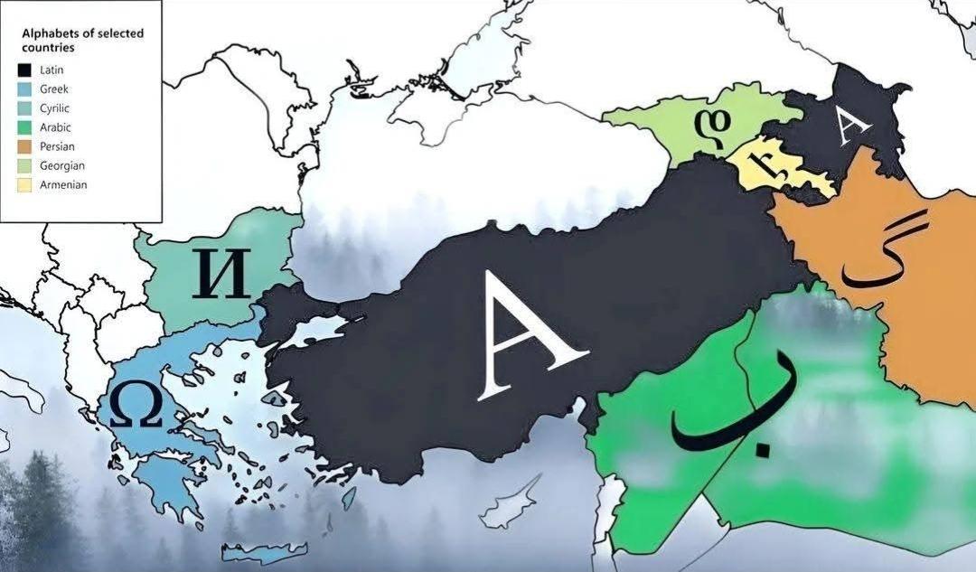
What This Map Shows
This map visualizes the geographical configuration of Türkiye, illustrating its borders with eight neighboring countries. The unique aspect highlighted here is that these countries are represented using seven different alphabets. This intriguing feature not only showcases Türkiye's strategic location at the crossroads of Europe and Asia but also reflects the cultural and linguistic diversity of the region. As we delve deeper into the implications of these borders, we will explore the significance of these relationships and how they shape the geopolitical landscape.
Deep Dive into Türkiye’s Borders
Türkiye shares its borders with eight countries: Greece, Bulgaria, Georgia, Armenia, Azerbaijan (Nakhchivan exclave), Iran, Iraq, and Syria. Each of these bordering nations presents a unique blend of cultural and linguistic influences, shaped by history and geography.
Interestingly, the borders not only delineate territorial lines but also represent a tapestry of interactions among diverse peoples and cultures. For example, the border with Greece is steeped in ancient history, while the border with Syria has been a focal point of modern geopolitical tensions.
The languages spoken in these neighboring countries add another layer of complexity. For instance, Greek uses the Greek alphabet, Bulgarian employs the Cyrillic script, while Azerbaijani is written in the Latin alphabet. This variety of alphabets reflects the rich historical narratives, colonial influences, and indigenous developments across the region.
Furthermore, the geographical features along these borders vary significantly. The mountainous terrain of the eastern borders with Iran and Armenia contrasts sharply with the coastal plains along the Aegean Sea bordering Greece. This diversity not only influences the climate but also affects the socio-economic activities in the border regions, from agriculture to tourism.
Regional Analysis
Let's break down Türkiye’s borders by regions to better understand the dynamics at play.
1. **Western Border (Greece and Bulgaria)**: Here, Türkiye shares a border with two EU countries, which influences trade and migration patterns significantly. The border with Greece is particularly active due to tourism, with many Greeks visiting Türkiye for its rich historical sites. On the other hand, the Bulgarian border is characterized by economic exchanges and cultural ties, with a significant Turkish minority residing in Bulgaria.
2. **Northeastern Border (Georgia and Armenia)**: This region has a more complex geopolitical landscape. Georgia’s border with Türkiye is marked by strong trade relationships, while the border with Armenia is tightly controlled due to historical conflicts. The cultural interactions in this area are fascinating, as both countries have rich historical legacies that influence their current relations.
3. **Eastern Border (Azerbaijan, Iran)**: The exclave of Nakhchivan connects Türkiye with Azerbaijan and presents a unique case of connectivity. This border is vital for energy transportation routes, particularly oil and gas pipelines. The border with Iran is significant due to shared ethnic ties and economic relations, though political frictions can arise due to differing regional policies.
4. **Southern Border (Iraq and Syria)**: The borders with Iraq and Syria are perhaps the most scrutinized due to the ongoing conflicts and humanitarian crises. The Syrian border, in particular, has seen significant refugee movements into Türkiye, reshaping demographics and social policies in the region. The southeastern provinces of Türkiye are heavily influenced by the Kurdish population, which straddles these borders.
Significance and Impact
The borders of Türkiye are not just lines on a map; they are dynamic zones of interaction that impact millions of lives. Understanding these borders is crucial for grasping the complexities of regional politics, economics, and cultural exchanges.
The significance of these borders extends beyond the immediate geopolitical landscape. For instance, trade routes that traverse these borders are vital for regional economies. The Turkish economy benefits significantly from its geographical position, facilitating trade between Europe and Asia.
Moreover, as global dynamics shift, the importance of Türkiye as a transit hub for energy resources and migration flows is likely to increase. Current trends suggest that Türkiye will continue to play a pivotal role in regional stability and economic development.
In conclusion, the map of Türkiye’s borders with eight countries using seven alphabets provides a compelling lens through which to view the intricate relationships that shape this region. Understanding these borders is vital for anyone interested in geography, geopolitics, or the rich cultural tapestry of this fascinating part of the world.
Visualization Details
- Published
- October 22, 2025
- Views
- 36
Comments
Loading comments...