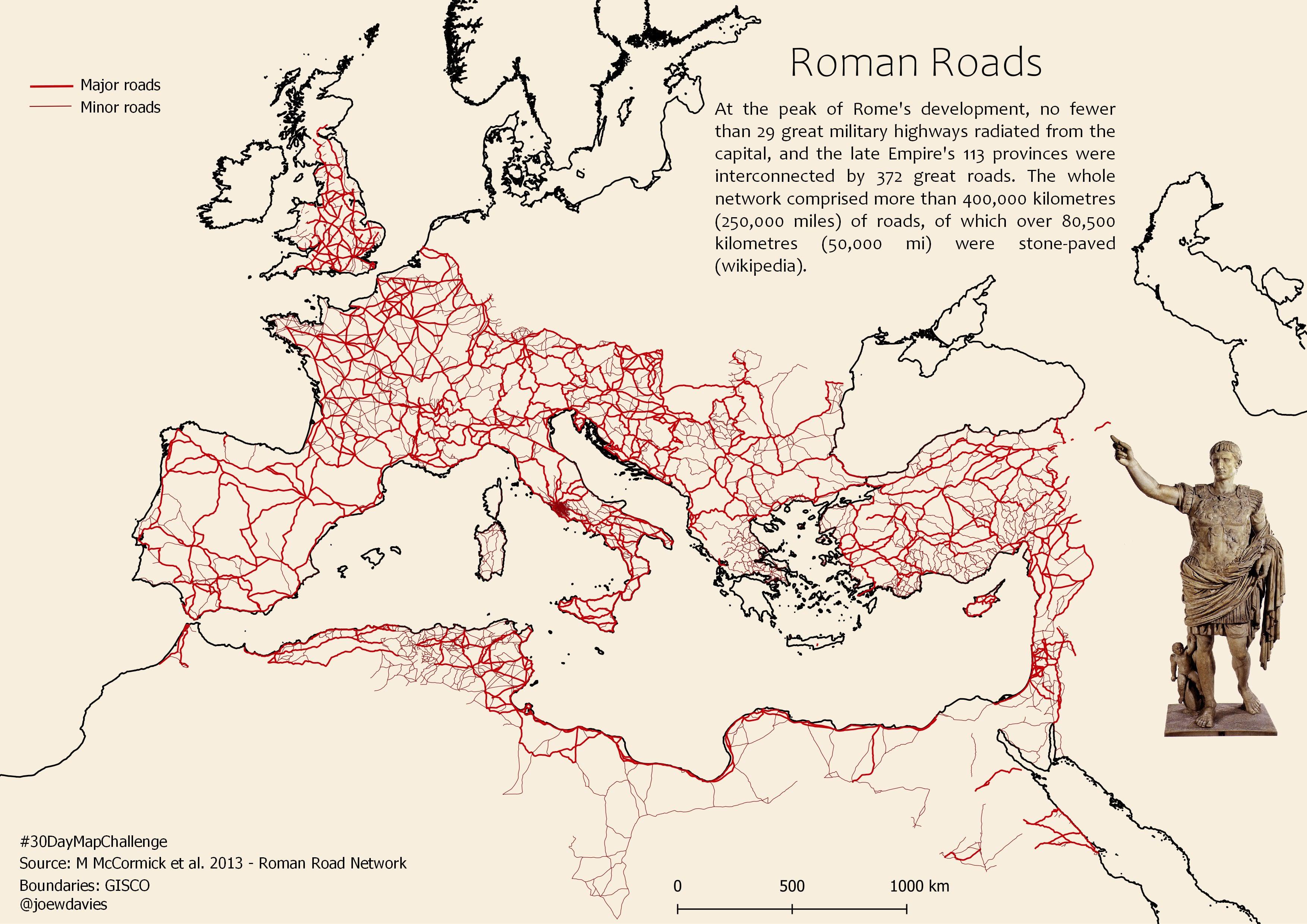
Map of Major and Minor Roads in the Roman Empire

Marcus Rodriguez
Historical Geography Expert
Marcus Rodriguez specializes in historical cartography and geographic data analysis. With a background in both history and geography, he brings unique...
Geographic Analysis
What This Map Shows
The map of major and minor roads across the Roman Empire reveals an intricate network of pathways that facilitated trade, military movements, and cultural exchange during one of history's most influential empires. Spanning three continents and connecting various provinces, this extensive system showcases how the Romans mastered the art of road construction and maintenance. The map highlights not just the primary routes that connected key cities like Rome, Constantinople, and Alexandria, but also the lesser-known paths that linked smaller towns and rural areas.
Deep Dive into Roman Road Systems
The road systems of the Roman Empire were revolutionary for their time and played a vital role in the expansion and administration of the empire. Generally, these roads can be classified into two categories: major roads, known as *viae*, and minor roads, often referred to as *vicinales* or *aggeres*. Major roads were constructed for long-distance travel and military logistics, while minor roads served local traffic and agricultural needs.
Interestingly, the Romans were meticulous in their road-building techniques. They utilized a multi-layered approach, consisting of a solid foundation of large stones, followed by smaller stones, gravel, and a final smooth surface of paving stones. This construction method ensured durability, allowing many Roman roads to endure for centuries, long after the empire itself had fallen.
Moreover, the layout of these roads was often remarkably straight, a testament to Roman engineering prowess. The phrase "All roads lead to Rome" encapsulates the idea that the city was the focal point of this vast network. Major routes emanating from Rome included the Via Appia, which connected the capital to the southern regions of Italy, and the Via Aurelia, which ran along the western coastline.
The Roman road network was not merely a physical infrastructure; it also served as a catalyst for economic growth. Trade flourished along these routes, enabling the exchange of goods such as olive oil, wine, and grain. Likewise, the movement of troops was streamlined, allowing for rapid military response to threats, which was essential for maintaining control over the empire's vast territories. During its height, the Roman Empire spanned approximately 2.5 million square miles, making efficient transportation crucial to its governance.
Regional Analysis
When examining the Roman road system by regions, distinct patterns emerge that reflect the geographical and cultural diversity of the empire. In Italy, for instance, roads like the Via Flaminia connected Rome to the northern regions, facilitating both commerce and military movements. The roads in this central area were often more developed due to the proximity to the capital, with larger cities benefitting from enhanced connectivity.
In contrast, the provinces of Gaul (modern-day France) and Hispania (Spain) displayed a different dynamic. Here, roads were strategically designed to connect provincial capitals like Lugdunum (Lyon) and Emerita Augusta (Mérida) to major trade hubs. The construction techniques were adapted to local conditions, demonstrating the Romans' ability to integrate their engineering knowledge with regional needs. For instance, in the hilly terrain of Hispania, roads were often built with switchbacks to navigate steep inclines.
The eastern provinces, including Asia Minor and the Levant, also had a unique road system. The Via Egnatia, which connected Dyrrhachium (modern-day Durrës) to Byzantium (Istanbul), was vital for trade between the West and East. Its construction facilitated the movement of not only goods but also ideas and cultural exchanges between diverse populations.
Significance and Impact
The significance of the Roman road network cannot be overstated. It laid the groundwork for modern transportation systems, influencing road construction and urban planning for centuries to come. Even in contemporary Europe, many major routes still follow the ancient paths established by the Romans. This enduring legacy reflects not just the engineering skill but also the administrative acumen of the Roman Empire.
Moreover, the efficient movement of people and goods contributed to the cultural integration of the empire, fostering a sense of unity among diverse populations. The roads facilitated the spread of Roman culture, language, and governance, which had lasting impacts on European civilization.
Interestingly, as we look at modern travel and trade routes, the historical importance of the Roman road system can still be seen, serving as a reminder of how infrastructure shapes societies. As we continue to study these ancient pathways, we gain insights not only into the past but also into how we can design future transportation networks that honor and learn from this remarkable history.
Visualization Details
- Published
- October 21, 2025
- Views
- 28
Comments
Loading comments...