
Alex Cartwright
Senior Cartographer & GIS Specialist
Alex Cartwright is a renowned cartographer and geographic information systems specialist with over 15 years of experience in spatial analysis and data...
Geographic Analysis
What This Map Shows
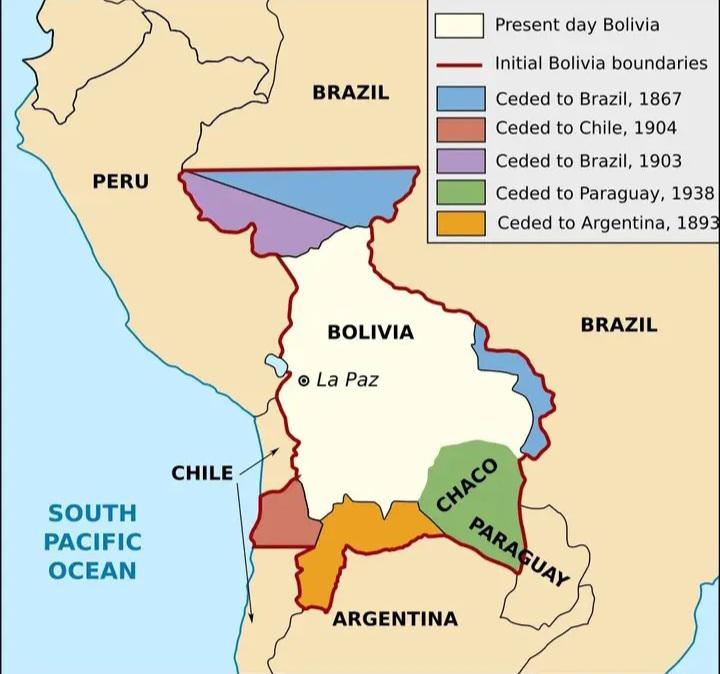
This map illustrates the evolving borders of Bolivia, highlighting the significant territorial losses the nation has endured since gaining independence in the early 19th century. The initial borders, depicted in red, contrast starkly with present-day Bolivia, shown in cream. The territories ceded to neighboring countries—Brazil, Chile, Paraguay, and Argentina—are marked in distinct colors, emphasizing the complex history of territorial conflicts and treaties that have shaped Bolivia's geographic and national identity.
Deep Dive into Bolivia's Territorial Changes
Bolivia's territorial history is marked by a series of conflicts and treaties that have stripped the nation of critical land. **The War of the Pacific** (1879–1884) stands out as a pivotal moment in Bolivian history. This conflict, primarily fought between Chile and a coalition of Bolivia and Peru, resulted in Bolivia losing its coastal territory and, consequently, its access to the Pacific Ocean. The loss of this access has had profound implications for Bolivia's economy, limiting trade routes and contributing to a landlocked status that persists today.
Interestingly, this war was not just a battle for land but also a struggle for resources. Chile's victory provided it with access to lucrative nitrate deposits, which would later play a crucial role in the country's economic development. For Bolivia, the loss was not merely geographical; it was an emotional and nationalistic blow that has echoed through generations.
Following the War of the Pacific, Bolivia faced further territorial challenges, notably with the **cession of Acre to Brazil in 1903**. Acre was rich in rubber, a resource that was in high demand during the rubber boom. This cession not only represented another loss of territory but also highlighted the economic motivations behind such territorial disputes during that era. The rubber boom was a double-edged sword; while it fueled economic growth in Brazil, it left Bolivia grappling with the consequences of losing a resource-rich area.
The **Chaco War** (1932–1935) against Paraguay was yet another chapter of territorial loss for Bolivia. This war, rooted in disputes over the Chaco Boreal region—a territory believed to be rich in oil—ended with Bolivia ceding significant land to Paraguay. The war's outcome was a bitter reminder of Bolivia's vulnerabilities, as it struggled with political instability and economic challenges during the early 20th century.
These territorial losses have not only impacted Bolivia's geography but have also contributed to a complex national identity. The feeling of loss has fostered a sense of resilience among the Bolivian people, who continue to advocate for their rights and seek to reclaim their national pride.
Regional Analysis
When examining the map, one can see how these territorial changes have influenced different regions of Bolivia. The western highlands, where cities like La Paz and Cochabamba are located, continue to be the political and cultural heart of the nation. However, the loss of access to the Pacific Ocean has limited economic opportunities, forcing Bolivia to rely on neighboring countries for trade routes.
In contrast, the eastern lowlands, which include regions like Santa Cruz, have experienced significant economic growth, largely due to agriculture and natural gas resources. This disparity in development raises questions about how territorial losses have shaped economic opportunities in various regions. For example, while Santa Cruz has flourished, other areas have struggled to adapt to the changes brought about by historical conflicts.
Additionally, the cultural implications of these territorial changes are noteworthy. Different regions of Bolivia have developed unique identities based on their historical experiences, and the memory of territorial loss remains a critical part of Bolivia's collective consciousness. The ongoing struggles for self-determination and resource control reflect the deep-seated impact of these historical events.
Significance and Impact
Understanding Bolivia's territorial history is crucial not only for geography enthusiasts but also for policymakers and historians. The implications of these territorial losses extend beyond borders; they impact trade, national identity, and regional relationships. Bolivia's landlocked status has led to ongoing negotiations with its neighbors to secure access to ports, a situation that remains unresolved today.
Moreover, the resilience shown by the Bolivian people in the face of such losses is a testament to their national spirit. Current trends indicate that Bolivia is working to strengthen its international relationships and explore new avenues for economic growth, such as tourism and sustainable resource management. This ongoing pursuit of economic independence and national pride reflects a broader narrative of resilience and adaptation in the face of historical adversity.
In conclusion, this map is not just a representation of borders; it is a powerful reminder of Bolivia's complex history and the enduring spirit of its people. The story of territorial loss and resilience is woven into the very fabric of Bolivian identity, shaping the nation in ways that continue to unfold today.
Visualization Details
- Published
- October 20, 2025
- Views
- 40
Comments
Loading comments...