Population Density Map of Central District Karachi

Alex Cartwright
Senior Cartographer & GIS Specialist
Alex Cartwright is a renowned cartographer and geographic information systems specialist with over 15 years of experience in spatial analysis and data...
Geographic Analysis
What This Map Shows
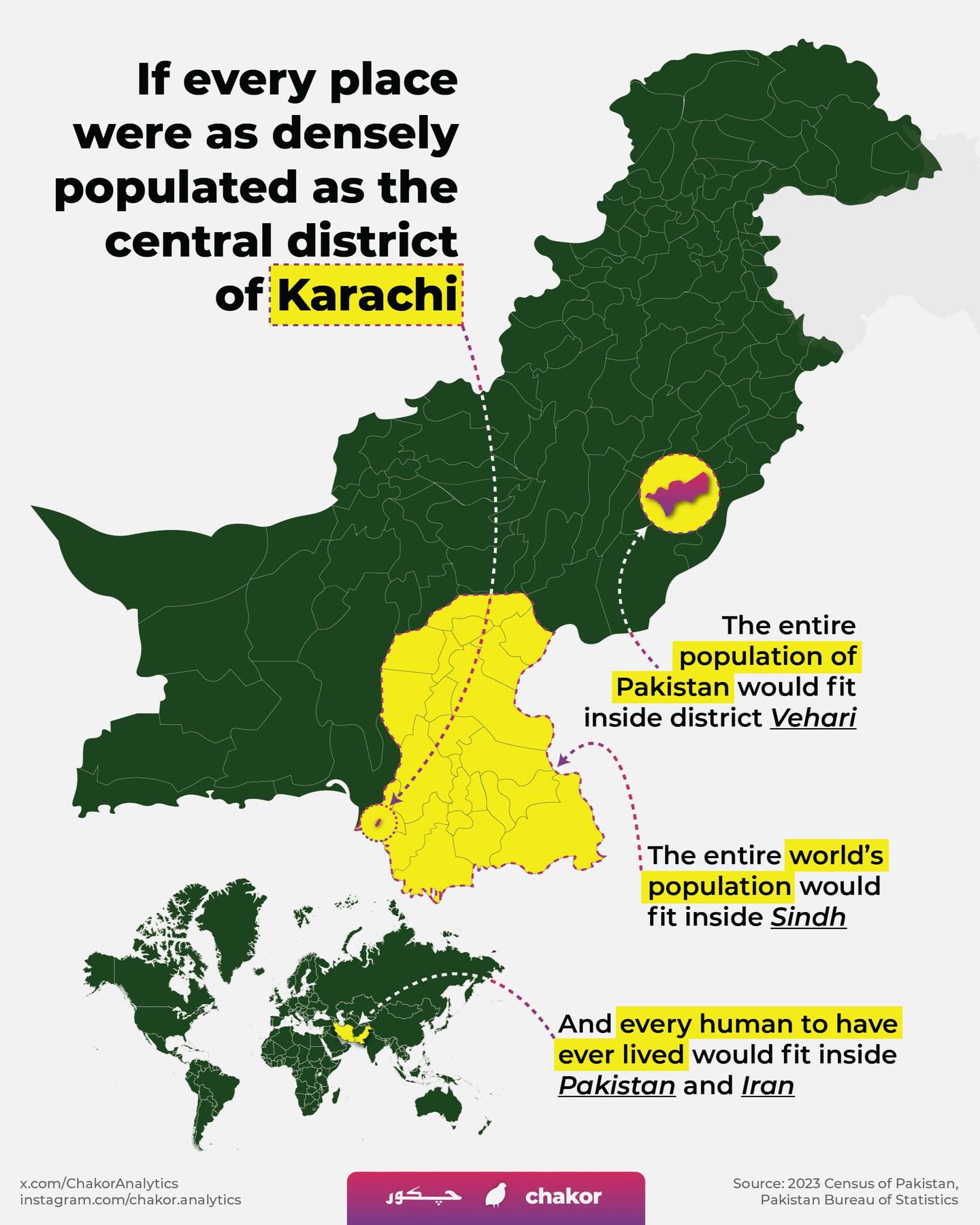
The "Population Density Map of Central District Karachi" offers a detailed visual representation of the distribution of the population within one of the busiest districts in Pakistan's largest city. This map illustrates not just numbers but the intricate patterns of human settlement that can tell us much about urban life, resources, and social dynamics in Karachi.
Deep Dive into Population Density in Karachi
Karachi, the bustling metropolis and financial hub of Pakistan, is home to a staggering population of over 14 million people. The Central District is one of the most densely populated areas in this sprawling city, showcasing a unique blend of residential, commercial, and industrial zones. What’s fascinating is how population density can reveal much about the socioeconomic status, urban planning, and infrastructure challenges within the area.
Population density is often calculated as the number of people living per square kilometer. In Central District Karachi, certain neighborhoods exhibit densities that far exceed the national average, which stands at approximately 265 people per square kilometer. Neighborhoods like Liaquatabad and Nazimabad are particularly noteworthy, with densities reaching upwards of 60,000 people in some sectors. This is largely due to the historical migration of people into Karachi from rural areas seeking better economic opportunities, resulting in the rapid urbanization of these localities.
Interestingly, the population distribution is not uniform. Areas closer to the main commercial hubs tend to have higher densities, while outlying parts of the district may feature more open spaces, albeit with their own growing populations. This concentration of people raises important questions about resource allocation, infrastructure development, and public services. Can the existing infrastructure support such a high density? What are the challenges faced by these densely packed communities?
Moreover, socioeconomic factors also play a crucial role in shaping population density. Higher density often correlates with lower income levels and inadequate access to quality healthcare, education, and sanitation. For instance, in Central District, the lack of adequate public transport and road networks can exacerbate the difficulties faced by residents who rely on these services for their daily commute.
Regional Analysis
Breaking down the population density in Central District Karachi reveals significant variations between neighborhoods. For example, neighborhoods like Orangi Town, known for its informal settlements, have some of the highest population densities. Here, the challenges of overcrowding are evident in the form of limited access to clean water and sanitation, which can lead to public health crises.
In contrast, areas like Gulshan-e-Iqbal, which are more developed and have seen considerable investment in infrastructure, show lower densities relative to their population size. This can be attributed to the availability of larger residential plots, better urban planning, and more green spaces. Interestingly, while Gulshan-e-Iqbal may have a less dense population, it faces its own challenges, such as rising property prices and urban sprawl.
This regional analysis underscores the disparities within the Central District. More affluent areas are often better equipped to handle population pressures, whereas poorer neighborhoods experience the brunt of overcrowding and infrastructural strain. Understanding these dynamics is crucial for informing urban policy and development strategies.
Significance and Impact
The implications of population density in Central District Karachi extend beyond mere numbers. As urban centers like Karachi continue to grow, the need for effective urban planning becomes paramount. High population density can lead to increased demand for housing, public services, and transportation, which in turn can strain existing resources.
Moreover, the challenges posed by high density are compounded by factors such as climate change, which threatens to exacerbate existing vulnerabilities. The risk of flooding, for instance, is heightened in densely populated areas with inadequate drainage systems. Addressing these issues requires comprehensive policy interventions that prioritize sustainable urban development.
Furthermore, with the ongoing trend of migration into cities, it’s essential to consider future projections. Will Central District Karachi continue to attract more residents, or will we see a shift as urbanization patterns change? Understanding population density is not just about assessing current conditions; it’s about preparing for the future and ensuring that all residents have access to the resources they need to thrive in an increasingly crowded urban landscape.
The population density map of Central District Karachi is more than just a representation of numbers; it is a reflection of the city's dynamic character and the challenges and opportunities that lie ahead. As we move forward, the insights garnered from this map will be invaluable in shaping the policies that govern urban life in Karachi.
Visualization Details
- Published
- October 17, 2025
- Views
- 30
Comments
Loading comments...