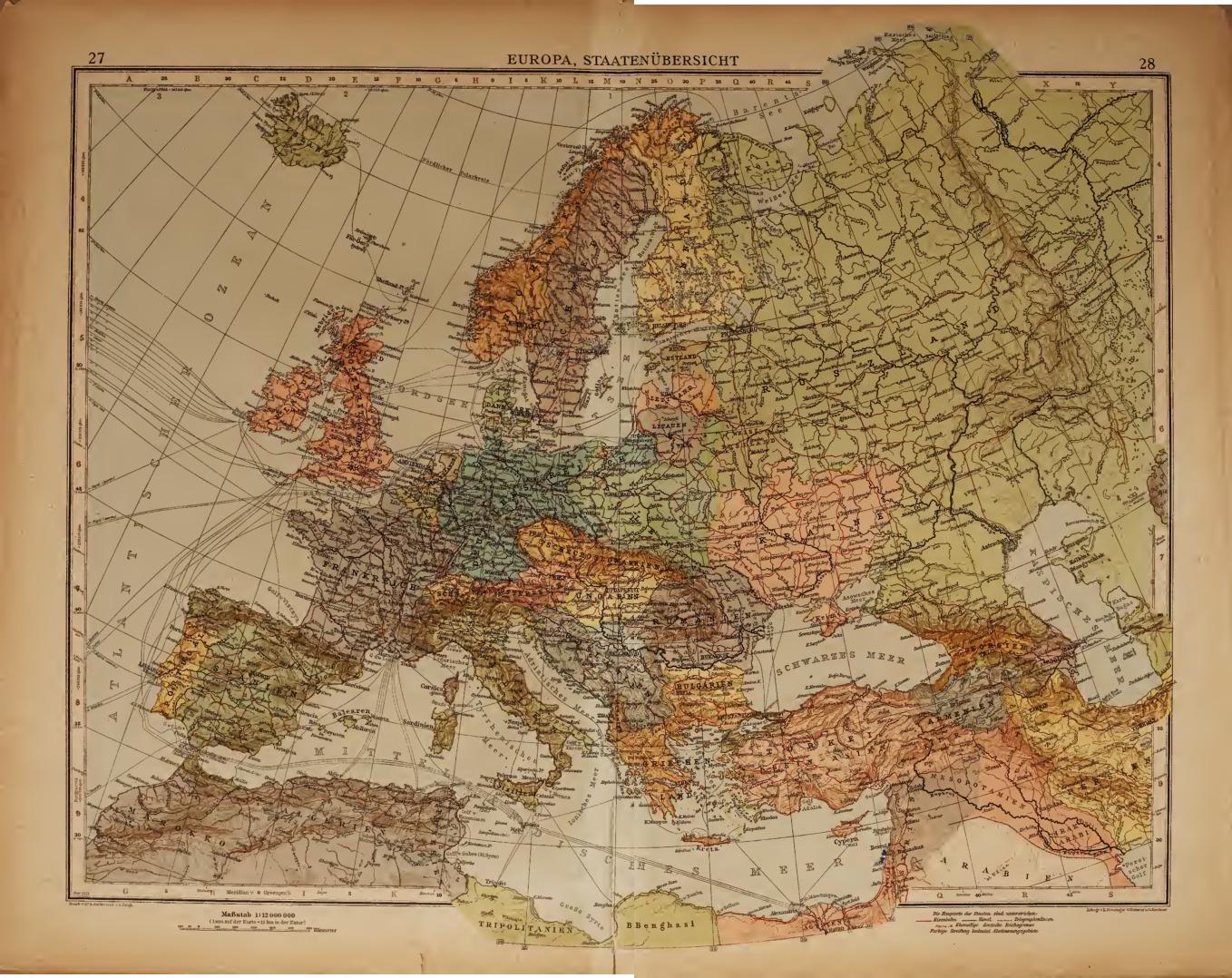
German Map of Europe After WW1

Alex Cartwright
Senior Cartographer & GIS Specialist
Alex Cartwright is a renowned cartographer and geographic information systems specialist with over 15 years of experience in spatial analysis and data...
Geographic Analysis
What This Map Shows
The map in question illustrates the geopolitical landscape of Europe immediately following World War I, highlighting the emergence of several independent states, including Ukraine, Belarus, and the nations of the Caucasus. This period was marked by significant upheaval, as the war's conclusion in 1918 led to the dissolution of empires and the redrawing of national borders. The map serves as a historical snapshot, providing insight into the new political realities that shaped Eastern Europe and the Caucasus region during the early 20th century.
Deep Dive into Post-WW1 Geopolitics
Following the end of World War I, the geopolitical map of Europe was dramatically altered. The collapse of empires, such as the Austro-Hungarian and Ottoman Empires, created a vacuum that gave rise to new nations and territorial claims. In this context, Ukraine and Belarus emerged as independent entities, reflecting the nationalist movements that gained momentum during and after the war.
Ukraine declared its independence in 1917, amid the chaos of the Russian Revolution. The Ukrainian People's Republic was proclaimed, although it faced immediate challenges from Bolshevik forces and neighboring countries seeking to capitalize on the region's instability. Interestingly, Ukraine's struggle for sovereignty was not merely a political one; it also encompassed cultural and linguistic factors that remain significant to this day. In fact, the Ukrainian language and national identity have been pivotal in the nation's quest for independence and self-determination.
Similarly, Belarus declared independence in 1918, forming the Belarusian People's Republic. However, this independence was short-lived as territorial disputes and external pressures soon led to its incorporation into the Soviet Union by the early 1920s. The Belarusian experience serves as a reminder of the fragile nature of national identity in the face of larger geopolitical forces.
In the Caucasus, the aftermath of the war saw the establishment of several independent republics, including Armenia, Azerbaijan, and Georgia. These states were born out of the ashes of the Russian Empire's collapse and faced their own sets of challenges, including ethnic conflicts and border disputes. The Caucasus region is particularly fascinating due to its diverse ethnic composition and strategic importance, serving as a crossroads between Europe and Asia. Each of these nations has navigated complex historical narratives, which continue to influence their contemporary political landscapes.
In summary, the post-WW1 period was a watershed moment for many Eastern European countries, as the map reflects a significant shift in national identities and political boundaries. The struggles for independence faced by Ukraine, Belarus, and the Caucasus nations highlight the broader themes of nationalism and self-determination that defined this era.
Regional Analysis
Examining the map more closely, it becomes clear that the newly independent states faced distinct challenges and opportunities based on their geographic locations and historical contexts. For instance, Ukraine, with its vast agricultural resources and industrial capacity, positioned itself as a potential breadbasket of Europe. However, its location also made it susceptible to external influences, particularly from neighboring powers like Russia and Poland.
Belarus, in contrast, found itself at the heart of competing interests between Russia and Poland, leading to a fluctuating national identity. The situation was exacerbated by the country’s relatively smaller size and population, which made it more vulnerable to external pressures. The map illustrates these territorial tensions, which would later manifest in the region's turbulent history throughout the 20th century.
In the Caucasus, Armenia, Azerbaijan, and Georgia each had unique challenges that were intrinsically linked to their ethnic compositions. For example, the territorial disputes that arose between Armenia and Azerbaijan over Nagorno-Karabakh are rooted in the complex ethnic dynamics that the map poignantly depicts. Similarly, the geopolitical significance of the Caucasus as a corridor for energy resources adds another layer of complexity to the region's political landscape.
Significance and Impact
Understanding the geopolitical changes in Europe after World War I is crucial for comprehending current geopolitical tensions. The map not only serves as a historical document but also as a reminder of the long-lasting impacts of nationalism and territorial disputes. For instance, the unresolved issues from this period still resonate today, influencing modern conflicts in Ukraine and the Caucasus.
Moreover, the emergence of these independent states laid the groundwork for the future political landscape of Eastern Europe. Interestingly, the desire for sovereignty and national identity that fueled independence movements in the early 20th century continues to shape the aspirations of nations today. With rising nationalism and ongoing conflicts, especially in Ukraine, the historical context provided by this map remains relevant.
In conclusion, the German map of Europe right after WW1 is not just a representation of borders; it encapsulates a transformative moment in history that continues to echo through contemporary geopolitics, reminding us of the complexities of national identity and the enduring quest for self-determination across the region.
Visualization Details
- Published
- October 15, 2025
- Views
- 48
Comments
Loading comments...