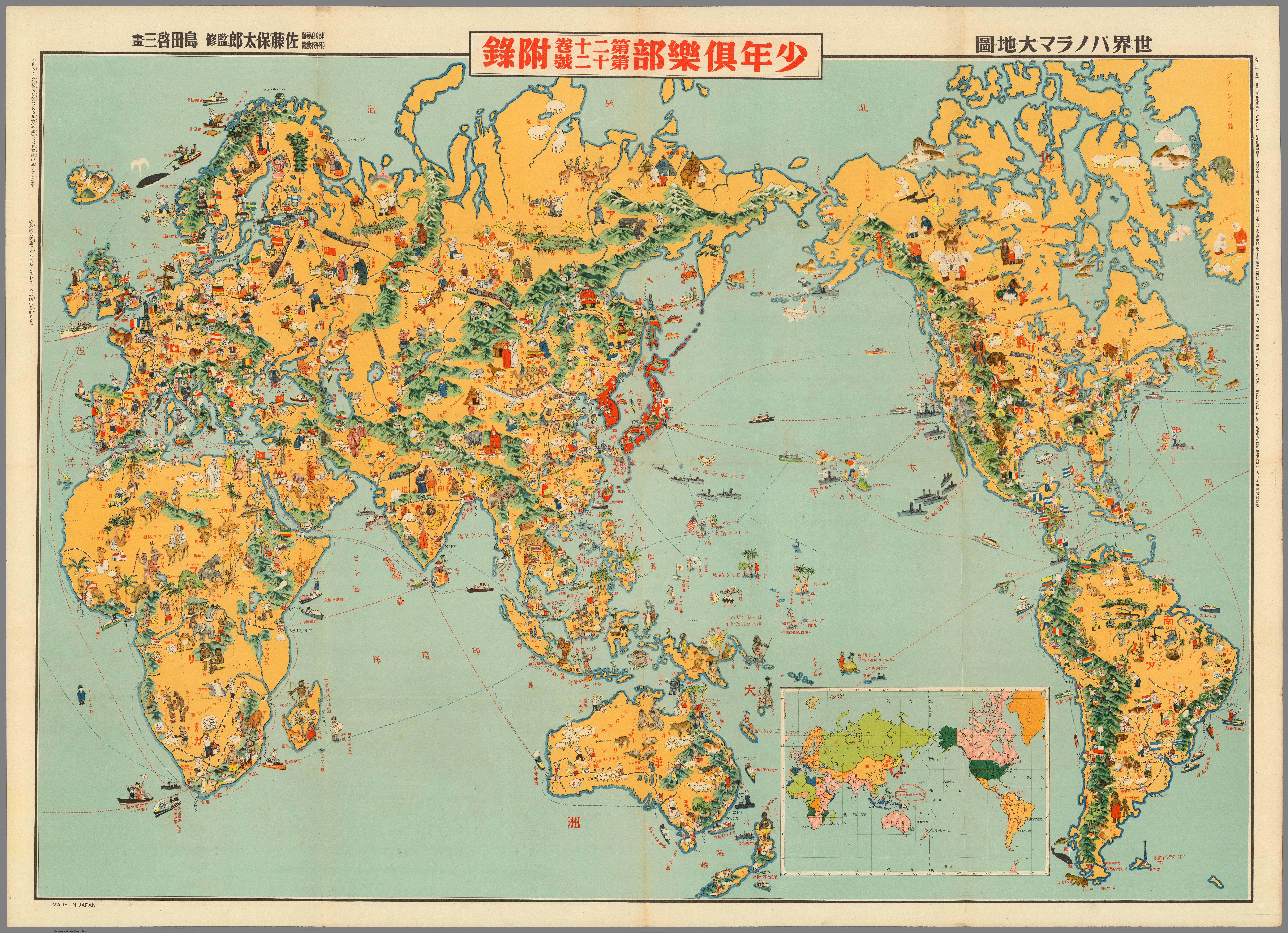
1933 Japanese Pictorial World Map Analysis


Alex Cartwright
Senior Cartographer & GIS Specialist
Alex Cartwright is a renowned cartographer and geographic information systems specialist with over 15 years of experience in spatial analysis and data...
Geographic Analysis
What This Map Shows
The 1933 Japanese pictorial world map is a fascinating representation of the world as seen through the lens of Japanese culture at the time. Unlike the traditional topographic maps we are accustomed to, this map employs vivid illustrations and artistic elements to convey geographical information. It combines geographical facts with cultural symbols and artistic flair, making it a unique artifact that reflects the worldview of Japan during the early 20th century. The map is not just a navigation tool; it serves as a cultural narrative, showcasing various countries and regions through their defining characteristics rather than strict geographical accuracy.
Deep Dive into Cultural Geography
Cultural geography is the study of how cultural practices, values, and beliefs are expressed and shaped by the geographical environment. The 1933 Japanese pictorial world map is a prime example of this intersection. It provides insights into how the Japanese viewed themselves in relation to other nations and cultures. Interestingly, the map illustrates not only the physical layout of countries but also highlights notable cultural elements such as traditional attire, local fauna, and even historical landmarks.
For instance, certain regions are adorned with illustrations that emphasize their cultural identity. Japan is depicted with iconic symbols like cherry blossoms and traditional architecture, which showcase its rich heritage. Meanwhile, other countries might be illustrated with their local wildlife or cultural artifacts, providing a snapshot of their societal values and historical context.
One of the most striking features of this map is how it reflects the geopolitical sentiments of the time. The 1930s were a tumultuous period in global history, with rising nationalism and tensions leading up to World War II. The way countries are represented on the map can reveal Japan's perceptions of its neighbors and its place in the world. For example, regions that are portrayed in a more detailed or favorable manner could indicate Japan’s diplomatic relationships or cultural admiration.
Regional Analysis
When breaking down the map by regions, we can observe distinct variations in representation. In East Asia, for example, countries like China and Korea are depicted with significant cultural symbols that emphasize their historical connections with Japan. However, the portrayal of Western nations often includes caricatures or stereotypes, reflecting the political tensions of the era.
In Europe, nations are often characterized by their historical landmarks or cultural icons, which might be exaggerated for artistic effect. For example, France may be represented with the Eiffel Tower, while the United Kingdom could be illustrated with elements like Big Ben. This artistic approach not only conveys geographical information but also implies a commentary on cultural dominance and perception.
Interestingly, the Americas are depicted in a more simplified manner, focusing less on cultural specifics and more on broad geographical features, possibly reflecting Japan's limited engagement with those regions at the time. This difference highlights how cultural geography is often shaped by historical and political interactions.
Significance and Impact
The significance of the 1933 Japanese pictorial world map goes beyond just its artistic value; it provides a lens through which we can examine Japan's historical context and cultural perceptions of the early 20th century. By analyzing this map, we gain insights into the collective identity of Japan and how it viewed itself in relation to the rest of the world.
Today, understanding such maps is crucial as they highlight the importance of cultural narratives in geography. They remind us that geography is not merely about physical landscapes but also about the human stories and relationships that shape our world.
Furthermore, as we navigate an increasingly globalized society, the lessons from this map resonate. Cultural awareness and sensitivity are more important than ever in our interconnected world. This map serves as a historical reminder of how cultural perceptions can influence international relations and personal interactions between diverse peoples. As we look ahead, it's essential to learn from these historical narratives to foster better understanding and cooperation among nations.
Visualization Details
- Published
- October 12, 2025
- Views
- 48
Comments
Loading comments...