Map of Antarctica in 1912

David Chen
Data Visualization Specialist
David Chen is an expert in transforming complex geographic datasets into compelling visual narratives. He combines his background in computer science ...
Geographic Analysis
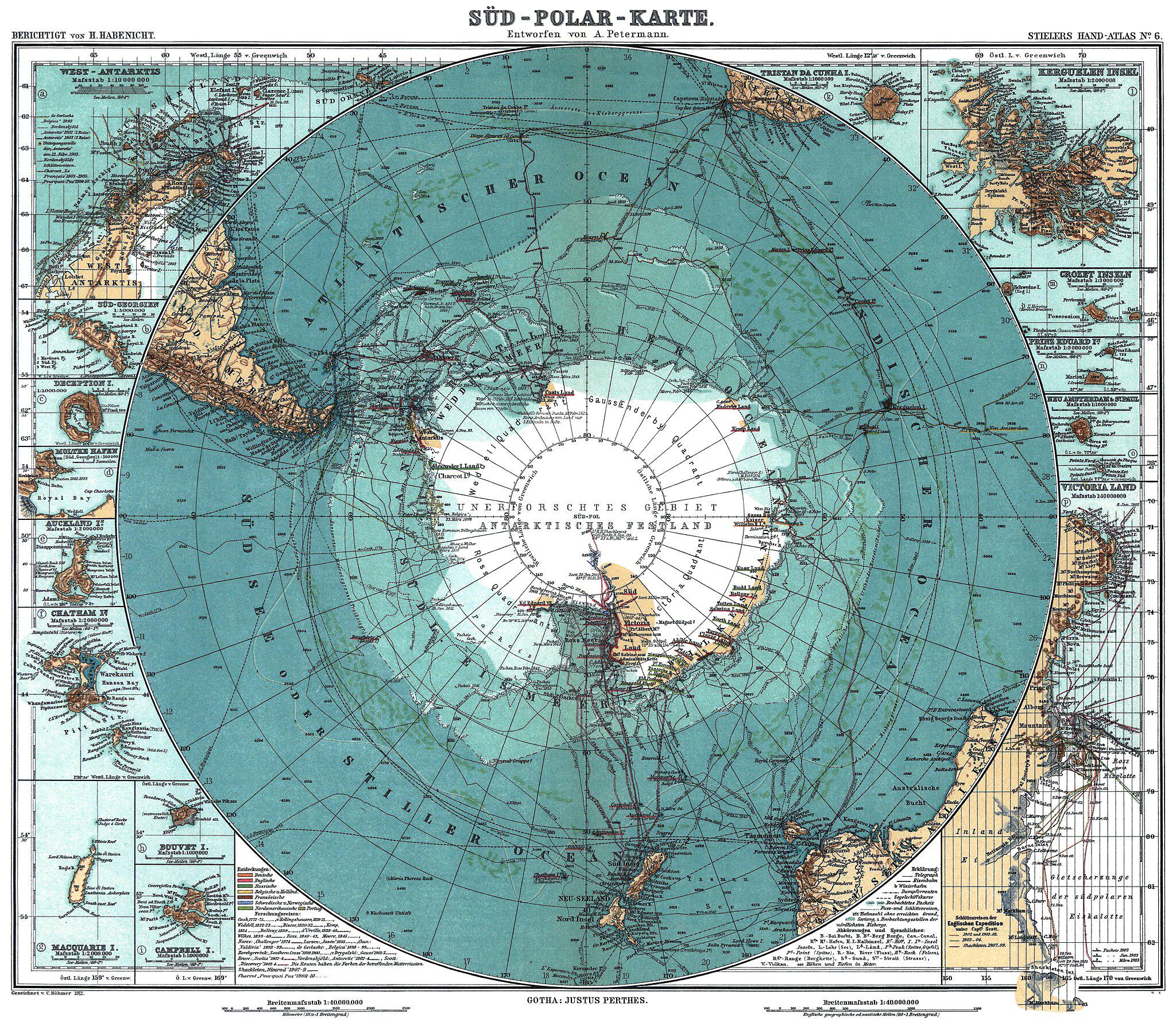
What This Map Shows
The 1912 map of Antarctica presents a fascinating glimpse into a time shortly after humanity's first successful expedition to the South Pole, led by Roald Amundsen in December 1911. This visualization captures not just the stark icy landscapes of Antarctica, but also marks the territories explored and charted by various explorers of the time. Notably, it showcases the geographical features, including mountain ranges, ice shelves, and the vast expanses of ice that define this remote continent. The map also highlights the locations of early research stations and the routes taken by exploratory missions, which are crucial for understanding the early stages of Antarctic exploration.
Deep Dive into Antarctic Exploration in 1912
Antarctica, often referred to as the last great wilderness, remained largely uncharted until the late 19th and early 20th centuries. By 1912, the continent had begun to reveal its secrets, thanks to daring explorers who braved treacherous conditions to uncover its mysteries. The race to the South Pole spurred multiple expeditions, each contributing to our understanding of this frigid land.
Interestingly, the early 20th century was marked by fierce competition among nations, particularly between Norway and Britain, in their quest to reach the South Pole first. Amundsen's successful journey was not just a triumph of navigation and endurance; it also laid the groundwork for future scientific exploration. Following Amundsen, British explorer Robert Falcon Scott's ill-fated Terra Nova Expedition sought to reach the pole, which ended tragically but ultimately led to important scientific contributions.
What's fascinating is that this period also marked the beginning of a systematic approach to studying Antarctica's environment. Explorers like Scott and Amundsen collected samples of rocks, ice, and biological specimens that provided invaluable data about the continent's geology and climate. The 1912 map reflects these early findings, showing the varied topography that includes the impressive Transantarctic Mountains and the vast East Antarctic Ice Sheet.
At this time, Antarctica was still a mystery in terms of its ecological and climatic conditions. The map gives a clear outline of the boundaries of these icy realms, but the understanding of the continent's climate dynamics was still in its infancy. Data from the early explorations suggested that Antarctica played a crucial role in global climatic patterns, a concept that has since gained much attention in climate science.
Regional Analysis
The map of Antarctica in 1912 can be divided into several key regions, each with its own characteristics and significance. The eastern region, dominated by the East Antarctic Ice Sheet, is known for its vast, stable ice cover. This area is crucial for understanding the historical climate of Earth, as ice cores extracted from this region provide insights into atmospheric conditions over millennia.
In contrast, the western region, often referred to as West Antarctica, is a more dynamic landscape marked by smaller ice sheets and more significant geological activity. This area has been the focus of recent studies due to its vulnerability to climate change. As temperatures rise, the stability of the West Antarctic Ice Sheet is increasingly in question, which has implications for sea-level rise globally.
Moreover, the map highlights key exploration routes, such as those taken by the British Antarctic Expedition of 1910-1913, which ventured into the Ross Sea area. It is here that researchers began to document the unique ecosystems of the Southern Ocean, a critical marine environment that supports a diverse range of life, from krill to whales. Each of these regions tells a distinct story of exploration, discovery, and the ongoing quest to understand Antarctica's role in the Earth's system.
Significance and Impact
The significance of exploring Antarctica cannot be overstated. The early 20th-century expeditions laid the foundation for contemporary research on climate change, glaciology, and marine biology. Understanding the historical context of Antarctica, as illustrated by the 1912 map, helps us recognize the continent's importance in our current climate crisis.
As we face global warming and its associated challenges, studying Antarctica offers clues about our planet's future. The ice sheets serve as indicators of climate change, and the data derived from ongoing research in these regions are vital for predicting future environmental shifts.
In conclusion, this map is more than just a representation of terrain; it is a testament to humanity's enduring curiosity and the relentless pursuit of knowledge about our planet's most remote areas. As interest in Antarctica continues to grow, it remains an essential focus for both scientific inquiry and international policy discussions regarding environmental preservation and climate action.
Visualization Details
- Published
- October 10, 2025
- Views
- 48
Comments
Loading comments...