
David Chen
Data Visualization Specialist
David Chen is an expert in transforming complex geographic datasets into compelling visual narratives. He combines his background in computer science ...
Geographic Analysis
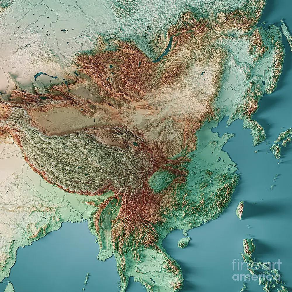
What This Map Shows
The East Asia topographic map presents a detailed view of the region's geographical features, highlighting its diverse elevations, landforms, and the notable Qing dynasty border. It showcases how mountains, plains, plateaus, and rivers shape the landscape, providing a vivid representation of the terrain that has influenced human settlement and development throughout history.
As we delve deeper into the topography of East Asia, we’ll explore the unique characteristics of its landscapes, from the towering Himalayas to the vast plains of northern China.
Deep Dive into East Asia's Topography
East Asia is a region characterized by its remarkable topographical variety. The most prominent feature is the Himalayan mountain range, which acts as a natural barrier on the southwestern border of the region. This mountain range, home to the world’s highest peak, Mount Everest, not only influences the climate but also plays a critical role in local ecosystems. Interestingly, the Himalayas trap moisture from monsoons, creating lush valleys and significant river systems, such as the Yangtze and Yellow Rivers that originate in this mountainous terrain.
As we move eastward, the landscape transitions into the Tibetan Plateau, often referred to as the 'Roof of the World.' This vast plateau, averaging over 4,500 meters above sea level, is the highest and largest plateau on Earth. Its harsh conditions and unique ecosystems have shaped the cultural and social practices of the Tibetan people who inhabit the region.
Then we have the North China Plain, which is one of the most fertile areas in the world. This flat landscape is crucial for agriculture, supporting a significant portion of China's population. The contrast between the mountainous regions and flat plains highlights the geological diversity of East Asia. Have you ever wondered how such variations in topography can influence local climates? Well, they certainly do! The western regions, dominated by mountains, experience a much drier climate compared to the eastern coast, where the ocean brings moisture and milder temperatures.
Furthermore, East Asia features several significant river systems. The Yangtze River, the longest river in Asia, flows through a variety of landscapes, from rugged mountains to expansive valleys. Its basin is one of the most densely populated areas in the world, showcasing how topography influences human activity. Similarly, the Yellow River, known as the 'Cradle of Chinese Civilization,' has shaped the cultural and agricultural practices of the region for millennia.
Regional Analysis
In examining the topography of East Asia more closely, we can segment the region into distinct geographical areas. The northeastern region, including parts of China and the Korean Peninsula, features extensive plains and hills, which support agriculture and urban development. Cities like Seoul and Shenyang benefit from this relatively flat terrain, allowing for easier infrastructure development.
In contrast, the southern regions, such as Taiwan and southern China, are marked by rugged mountain ranges and steep hills, which significantly impact settlement patterns. Urban areas like Kaohsiung in Taiwan are condensed along the coast, where the terrain allows for easier access to trade and resources. Interestingly, these mountainous areas are also home to diverse ecosystems, contributing to biodiversity in the region.
The coastal regions, particularly Japan's islands, offer another layer of complexity to East Asia's topography. Japan’s mountainous interior contrasts sharply with its coastal plains, creating unique climatic conditions that have influenced both agriculture and habitation. The interplay between mountains and the ocean results in heavy rainfall and a temperate climate, ideal for rice cultivation—a staple of the Japanese diet.
Significance and Impact
Understanding the topography of East Asia is crucial for various reasons. It influences not only the climate and weather patterns but also the distribution of resources and population. The rugged terrain has historically acted as a barrier, shaping political boundaries and cultural identities. For instance, the clear delineation of the Qing dynasty's borders reflects how topography can influence historical governance and territorial claims.
Moreover, with current trends in urbanization and climate change, the implications of this topography are becoming even more critical. Regions with fertile plains may face challenges such as overpopulation and environmental degradation, while mountainous areas might struggle with accessibility and resource management. As climate patterns shift, understanding how these landscapes respond can help in planning sustainable development and disaster management strategies.
In conclusion, the East Asia topographic map is not just a representation of physical features; it is a gateway to understanding the complex interplay between geography, culture, and human activity. The diverse landscapes of East Asia continue to shape the lives of millions, making the study of this region's topography both fascinating and essential for future generations.
Visualization Details
- Published
- October 7, 2025
- Views
- 42
Comments
Loading comments...