1581 Map of the Known World by Heinrich Bünting

Alex Cartwright
Senior Cartographer & GIS Specialist
Alex Cartwright is a renowned cartographer and geographic information systems specialist with over 15 years of experience in spatial analysis and data...
Geographic Analysis
What This Map Shows
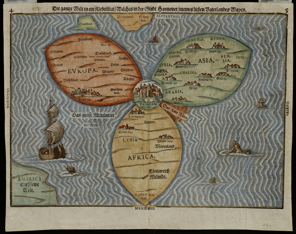
The 1581 Map of the Known World by Heinrich Bünting presents a unique and whimsical depiction of the world, structured in the form of a trefoil or cloverleaf. This fascinating cartographic artifact reflects a Medieval worldview, where the continents of Asia, Europe, and Africa are prominently displayed in three distinct leaves, with Jerusalem marked at their intersection. Interestingly, this representation was not merely a practical map for navigation or geographic understanding; it served as a symbolic reflection of the cultural and religious priorities of the time. The map also includes America, but only as an afterthought in the lower left-hand corner, signaling the evolving understanding of geography in the late 16th century.
Deep Dive into the Medieval Worldview
The map encapsulates the prevalent thinking of the time, which was predominantly shaped by religious and historical narratives rather than empirical geographic knowledge. Each of the three leaves represents a continent, with Asia depicted at the top, Europe on the right, and Africa on the left. This arrangement reflects the medieval perception of the world, where Jerusalem, the center of Christian belief, holds a pivotal position. This focus on Jerusalem underscores the religious significance of geography during this period; it was not just about physical space but spiritual geography as well.
Interestingly, while the map appears to be a simplistic representation of the world, it reveals much about the knowledge and beliefs of the era. For instance, Asia is often depicted as the largest continent, reflecting its historical importance as the birthplace of major civilizations and religions. Europe, the heart of the Christian world, is shown with great detail, emphasizing its cultural dominance at the time. Meanwhile, Africa is portrayed with less emphasis, reflecting the limited understanding and exploration of the continent by European scholars.
What’s fascinating is that the inclusion of America, albeit as a secondary element, shows the shift in European awareness following the New World discoveries. However, the way it is presented—almost as an afterthought—highlights the ongoing struggle between old worldviews and new geographic realities. The map serves as a bridge between medieval and early modern thought, illustrating how geography was evolving in response to new discoveries and cultural exchanges.
Regional Analysis
When breaking down the continents represented in Bünting's map, we can see distinct characteristics emerge. Asia, being the largest leaf, is not only a geographical giant but also a cultural one. It represents a tapestry of languages, empires, and philosophies, ranging from the vast territories of the Ottoman Empire to the rich traditions of China and India. In contrast, Europe, though smaller in representation, was rapidly advancing in terms of exploration and scientific inquiry. The Renaissance had begun to reshape European understanding of the world, and maps like Bünting's reflect this tension between tradition and modernity.
Africa, depicted less prominently, reflects the limited interactions Europeans had with the continent at that time. The map indicates a lack of detailed knowledge about African kingdoms, which would later become central to European colonial ambitions. The differences in portrayal highlight the varying degrees of exploration and understanding across the continents.
Significance and Impact
The significance of Heinrich Bünting's map lies in its ability to illustrate the complex interplay between geography, culture, and religion during the late 16th century. It reflects a worldview that prioritized spiritual over empirical knowledge, making it a valuable artifact for understanding historical perspectives on geography.
Today, maps like this remind us of the journey of human understanding and the evolution of cartography. They serve as a lens through which we can examine not only the physical world but also the cultural and historical narratives that shape our perceptions of it. Moreover, as we consider current trends in geography and cartography, we see an increasing emphasis on inclusivity and diverse perspectives, moving away from Eurocentric representations.
As we look to the future, the historical insights gained from maps like Bünting’s can inform how we approach global issues today, reminding us that geography is not just about space but also about the stories and cultures that inhabit it. Have you ever wondered how the maps of today will be viewed in the future? It's a thought-provoking question that connects us to the legacies of our past and the possibilities of our future.
Visualization Details
- Published
- October 6, 2025
- Views
- 46
Comments
Loading comments...