Administrative Divisions of Germany Map 1870

Marcus Rodriguez
Historical Geography Expert
Marcus Rodriguez specializes in historical cartography and geographic data analysis. With a background in both history and geography, he brings unique...
Geographic Analysis
What This Map Shows
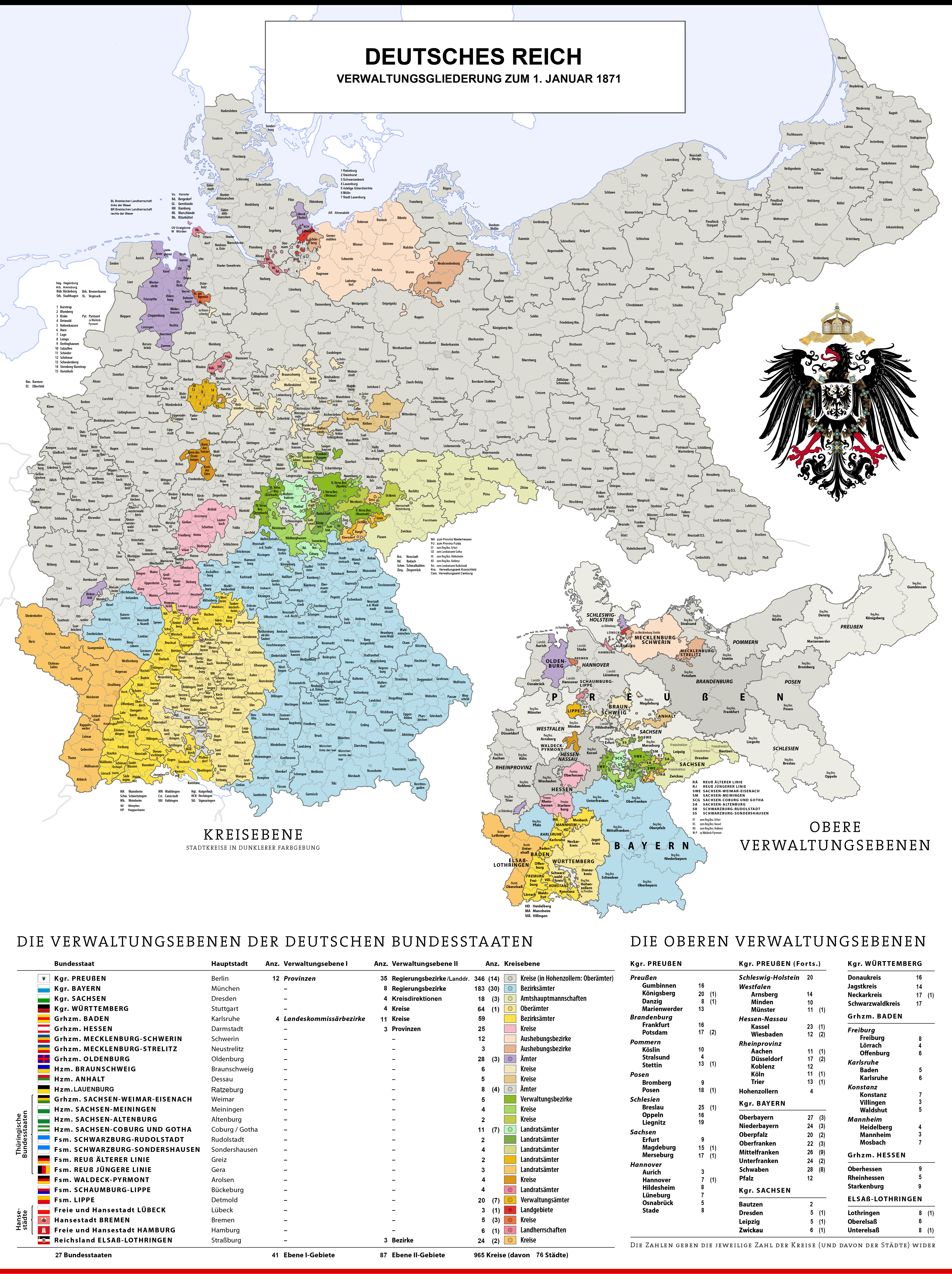
This historical map illustrates the administrative divisions of Germany as they existed on January 1, 1870. At this time, Germany was a patchwork of various states, kingdoms, and principalities, reflecting a complex and rich political landscape. The map captures the intricate boundaries that defined the German Empire's administrative structure, prior to the unification of Germany in 1871.
Deep Dive into Administrative Divisions of Germany
The administrative divisions portrayed in this map are crucial for understanding the political evolution of Germany during the 19th century. In 1870, Germany was not yet a unified nation-state but rather a collection of independent entities. The most significant were the Kingdoms of Prussia, Bavaria, Saxony, and Württemberg, each with their own governance and social structures. Additionally, there were various duchies, principalities, and free cities, such as Hamburg and Bremen, which operated autonomously.
Interestingly, the Kingdom of Prussia was the largest and most influential of these states, occupying a considerable portion of northern and eastern Germany. It was instrumental in the push toward unification, driven by Otto von Bismarck's policies that aimed to consolidate German territories under Prussian leadership.
The map also highlights the complexities of territorial administration. Each state had its own legal system, taxation policies, and military organization. For example, the smaller states often relied on Prussia for defense and economic stability, creating a system of interdependence that would eventually contribute to calls for unification.
In terms of demographics, the map offers a snapshot of a diverse population. The major cities, such as Berlin, Munich, and Dresden, were cultural and economic hubs, while rural areas in regions like Bavaria and Saxony showcased a more agrarian lifestyle. The population distribution reflected a mix of ethnicities and languages, particularly in border regions, where tensions often flared.
In addition to the political and demographic aspects, the administrative divisions had significant implications for trade and transportation. Major trade routes were often dictated by these boundaries, with rivers like the Rhine and Elbe playing crucial roles in connecting different regions. The development of railways in the following decades would further transform these dynamics, laying the groundwork for a more integrated national economy.
Regional Analysis
Taking a closer look at the map, we can see distinct regional characteristics that influenced the administrative divisions. In the north, Prussia dominated, not only in size but also in economic power. The industrial revolution was in full swing, and cities like Essen and Dortmund were becoming centers of manufacturing, leading to a shift in population from rural to urban.
In contrast, southern Germany, particularly Bavaria, maintained a strong sense of regional identity. The Bavarian Kingdom was known for its cultural heritage, reflected in its unique dialect, traditions, and festivals. This regional pride often resulted in a resistance to Prussian dominance, complicating the unification process.
The eastern regions, especially areas like Silesia, showcased a mix of German and Slavic populations. This diversity created a unique cultural tapestry, but also posed challenges regarding governance and social cohesion. The map serves as a reminder of the ethnic complexities that would later influence political decisions, especially as Germany approached the tumultuous years of the 20th century.
Significance and Impact
Understanding the administrative divisions of Germany in 1870 is essential for grasping the historical context leading to the unification of Germany in 1871. This map not only illustrates political boundaries but also encapsulates the social, economic, and cultural dynamics of the time.
The implications of these divisions extend far beyond the 19th century. The legacy of these boundaries can still be felt today, influencing regional identities and political landscapes. Furthermore, the tensions that arose from the diverse populations within these divisions foreshadowed the conflicts that would eventually lead to World War I and the subsequent changes in European borders.
In contemporary discussions about nationalism and regionalism, the map serves as a poignant reminder of how historical divisions can shape modern identities. Have you noticed how the echoes of the past influence current politics in Germany and beyond? As we continue to explore these themes, it becomes clear that geography is not just about maps; it’s about the stories they tell and the people they represent.
Visualization Details
- Published
- October 6, 2025
- Views
- 44
Comments
Loading comments...