Tribes of Britain and Ireland Map

David Chen
Data Visualization Specialist
David Chen is an expert in transforming complex geographic datasets into compelling visual narratives. He combines his background in computer science ...
Geographic Analysis
What This Map Shows
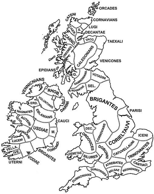
The "Tribes of Britain and Ireland around the time of Julius Caesar’s invasion" map visually represents the various tribal groups inhabiting the British Isles during the late Iron Age, around 55 BC. This period marked a significant moment in British history as Julius Caesar's forces began their incursions into the territory. The map outlines the geographical boundaries and locations of these tribes, providing insight into their distinct cultures, languages, and territories.
Transitioning from the visual aspect of the map, it is essential to understand the unique tribal landscape that existed in Britain and Ireland at this time. Each tribe not only occupied a specific area but also maintained its own identity and governance, which played a crucial role in the region's history and development.
Deep Dive into the Tribes of Britain and Ireland
During this era, Britain and Ireland were home to a diverse range of tribes, each with its own social structure, economy, and customs. The most notable tribes included the Iceni, Trinovantes, and Brigantes in Britain, while the Gaels and Picts inhabited parts of what is now Ireland and Scotland. Interestingly, the diversity among these groups reflects a complex tapestry of cultures influenced by trade, warfare, and alliances.
The Iceni tribe, for instance, was situated in what is now Norfolk and is famously known for their rebellion against Roman rule led by Queen Boudica. Their resistance highlighted the importance of tribal unity and the fierce independence characteristic of many tribes during this time. The Trinovantes, located in Essex, were known for their wealth and trade connections, particularly with the Romans, which enabled them to thrive economically.
In contrast, the Brigantes, the largest tribe in northern Britain, occupied vast territories across Yorkshire and Lancashire. Their strategic position allowed them to control key trade routes, which undoubtedly contributed to their prominence. What's fascinating is that these tribes were not merely isolated groups; they often engaged in trade and conflict with one another, shaping the political landscape of the region.
As for Ireland, the landscape was dominated by the Gaels and the Picts. The Gaels, known for their rich tradition in poetry and storytelling, spread their influence across much of Ireland and into western Britain. Meanwhile, the Picts, recognized for their enigmatic carved stones and tattoos, also played a significant role in the cultural identity of Scotland. Their interactions with the Romans, albeit limited, revealed a complex relationship characterized by both conflict and intrigue.
Regional Analysis
Examining the map reveals distinct regional characteristics among these tribes. In southeastern Britain, the Trinovantes and Iceni showcased a more urbanized lifestyle, likely due to their proximity to trade routes connecting them to the Continent. The wealth generated from trade with the Romans allowed these tribes to develop more sophisticated social structures and fortifications.
Conversely, in the north, the Brigantes displayed a more agrarian society, with a strong focus on tribal governance and defense against external threats. Their territory was marked by fortified hilltops and a series of alliances with other tribes to maintain their influence. In Ireland, the Gaels' presence along the eastern coast contrasted with the more isolated Picts in the north, whose fierce independence often led to conflicts with both the Gaels and any encroaching Roman forces.
Significance and Impact
Understanding the tribal dynamics of Britain and Ireland during this period is essential for appreciating the historical narrative that shaped the Isles. The interactions between these tribes, their responses to Roman expansion, and their eventual unification or division under various pressures set the stage for the complex socio-political landscape of medieval Britain.
Moreover, this historical context reflects ongoing themes in modern geopolitics, such as identity and cultural preservation. The legacy of these tribes continues to influence cultural identities in Britain and Ireland today. For instance, modern Celtic identity in Scotland and Wales can trace its roots back to these ancient tribes.
As we look toward the future, it’s intriguing to consider how the historical significance of these tribes might impact contemporary discussions around nationalism and regional autonomy. The map serves not only as a historical document but also as a reminder of the rich tapestry of cultural identity that exists in Britain and Ireland today, shaping the ongoing narrative of these regions.
Visualization Details
- Published
- October 6, 2025
- Views
- 36
Comments
Loading comments...