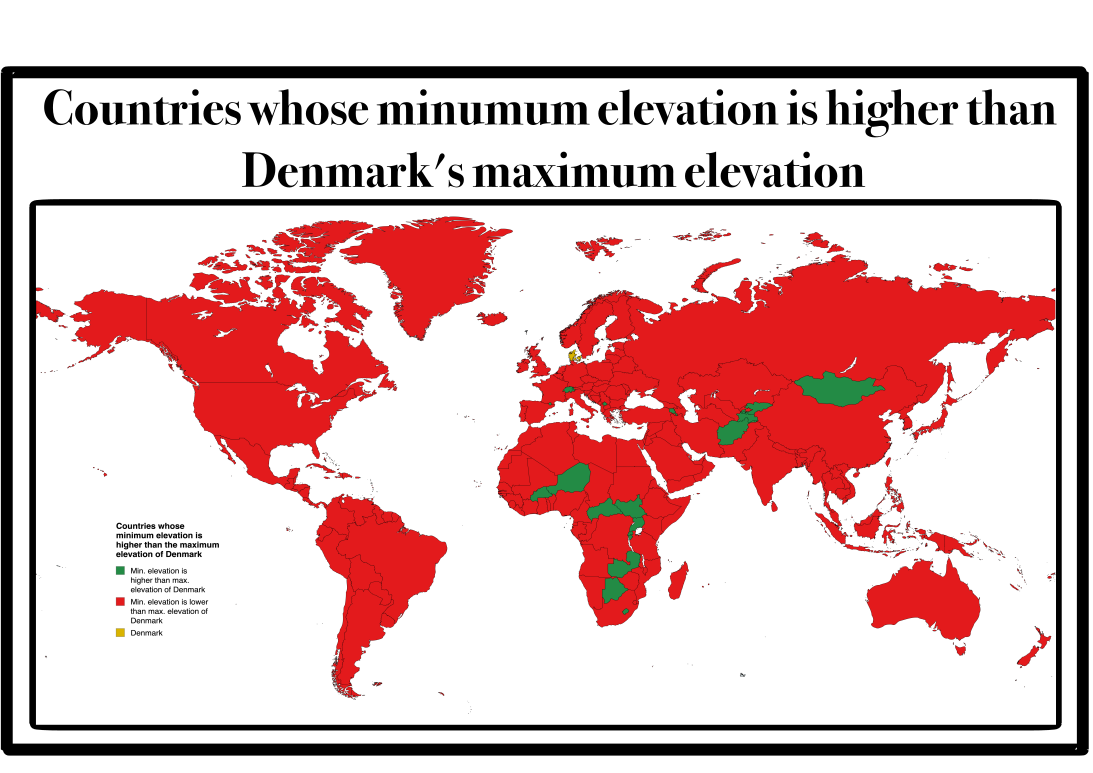
Map of Countries with Higher Lowest Points than Denmark

David Chen
Data Visualization Specialist
David Chen is an expert in transforming complex geographic datasets into compelling visual narratives. He combines his background in computer science ...
Geographic Analysis
What This Map Shows
This map presents a unique geographical insight: it highlights countries whose lowest point is situated at a higher elevation than Denmark's highest point. To clarify, the highest point in continental Denmark is Møllehøj, which stands at 171 meters (561 feet) above sea level. In contrast, the countries displayed on this map feature their lowest points above this elevation, creating a fascinating juxtaposition against Denmark's relatively flat terrain.
Deep Dive into Elevation Extremes
Elevation plays a crucial role in shaping a country's geography, climate, and even culture. The lowest points of countries can often be surprising; while many associate low elevations with deserts or basins, these areas can also be rich in biodiversity and unique ecosystems. Countries like Egypt, with its famous Qattara Depression at -133 meters (-436 feet), or the Dead Sea Depression in Jordan and Israel, showcase how low points can be an integral part of the geographical narrative.
Interestingly, when we look at countries with their lowest points higher than Denmark's highest, we find a variety of landscapes and climates. For instance, countries such as Afghanistan, where the lowest point is the Amu Darya River at around 258 meters (846 feet), illustrate how mountainous regions can significantly affect low elevation points. The presence of vast mountain ranges, such as the Hindu Kush, allows these nations to maintain higher low points despite their overall topography.
These geographic extremes also impact human activity. For example, in Switzerland, known for its towering Alps, the lowest point is the Rhone River at 372 meters (1,220 feet), making it not just a nation of peaks but also one of significant valleys that are vital for agriculture and habitation. The elevation of a country's lowest point can influence everything from agricultural practices to settlement patterns.
Have you ever noticed that countries with more rugged terrain often have higher lowest points? This can often be attributed to the geological formations and tectonic activities that shape these regions. As a result, countries like Bhutan, with its lowest point at the Manas River (approximately 200 meters or 656 feet), showcase the impressive heights of the Himalayas that dominate its landscape.
Regional Analysis
When analyzing the countries featured in the map, we can break them down regionally. For example, in Europe, many countries are relatively flat, yet we see countries like Andorra, whose lowest point is higher than Denmark's. This tiny nation, nestled in the Pyrenees, has elevations that reflect its mountainous landscape, contrasting sharply with Denmark's coastal plains.
In Asia, nations like Nepal and Bhutan stand out not just for their stunning peaks but also for their elevated low points. Conversely, countries like India, despite being home to vast plains and plateaus, have specific areas that are lower than Denmark's highest point due to the vastness of their geography.
In the Americas, countries like Venezuela, with its lowest point at 0 meters (the shores of Lake Maracaibo), provide a unique contrast. The presence of both high mountains and low coastal areas leads to diverse ecosystems and climatic conditions, highlighting the dynamic geography of the region.
Significance and Impact
Understanding the geography of elevation is essential for various reasons. Firstly, it informs us about climate patterns and the potential for natural disasters. Countries with higher elevations tend to experience different weather phenomena compared to their low-lying counterparts. This can influence agriculture, water resources, and even tourism.
Moreover, as climate change continues to impact global weather patterns, countries with varying elevations are increasingly at risk. Areas with lower elevations may face significant flooding, while mountainous regions may deal with the challenges of melting glaciers and changing ecosystems.
In conclusion, the map revealing countries whose lowest points are higher than Denmark's highest point not only provides an interesting geographical trivia but also serves as a reminder of the rich diversity of our planet's landscapes. By examining these elevation extremes, we can better appreciate the interplay between geography, climate, and human activity, fostering a deeper understanding of the world we inhabit.
Visualization Details
- Published
- October 2, 2025
- Views
- 42
Comments
Loading comments...