Watershed Boundaries Map Proposal for the U.S.

Marcus Rodriguez
Historical Geography Expert
Marcus Rodriguez specializes in historical cartography and geographic data analysis. With a background in both history and geography, he brings unique...
Geographic Analysis
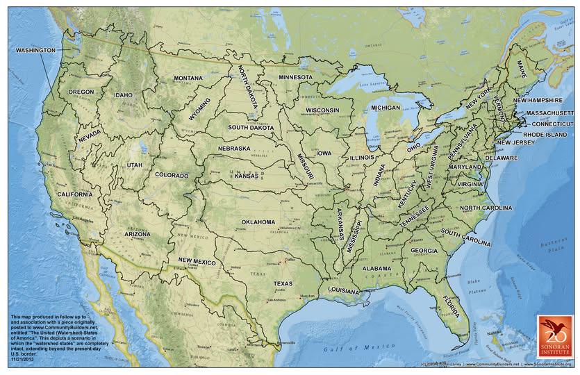
What This Map Shows\nThis visualization presents a proposal to divide the United States by watershed boundaries, as originally conceptualized by John Wesley Powell. It illustrates how the country could be reorganized based on the natural flow of water rather than political or state lines. Each watershed delineates a specific area where precipitation collects and drains into a common outlet, such as a river, lake, or ocean. This approach emphasizes the interconnectedness of ecosystems and human activities across regions, urging us to consider how water resources shape our landscapes and communities.
Deep Dive into Watersheds\nWatersheds are crucial geographical features that dictate the movement of water across the land. They consist of various components, including rivers, streams, and lakes, which play a vital role in maintaining the ecological balance within a region. Interestingly, the concept of dividing the U.S. by watershed boundaries is not just a theoretical exercise; it is rooted in practical considerations regarding resource management, conservation efforts, and environmental sustainability.
Understanding the significance of watersheds begins with recognizing their hydrological cycle. When it rains, water doesn't just disappear; it flows through various pathways, eventually making its way to larger bodies of water. This flow influences everything from soil composition to the health of local ecosystems. For instance, the Mississippi River watershed covers over 1.2 million square miles and includes parts of 32 U.S. states, draining water from as far north as Minnesota down to the Gulf of Mexico. The health of this watershed directly affects agriculture, fishing industries, and urban water supplies.
Moreover, watersheds can vary significantly in terms of their size and shape. Some, like the Colorado River watershed, are relatively small and confined, while others span vast areas, as is the case with the Great Lakes watershed. The diversity of watersheds across the U.S. means that local climates, soil types, and vegetation patterns can differ dramatically. For example, the arid landscapes of the Southwestern watersheds contrast sharply with the lush, fertile regions found in the Pacific Northwest.
However, it's essential to consider how human activity impacts these natural systems. Urbanization, agriculture, and industrialization can introduce pollutants into watersheds, affecting water quality and aquatic life. The concept of managing watersheds holistically can help mitigate these issues. By organizing land use around watershed boundaries, communities can foster better cooperation between states and localities, aiming for sustainable management practices that benefit both people and the environment.
Regional Analysis\nBreaking down the U.S. into watershed regions reveals striking differences in how water resources are managed and utilized. In the Northeast, for example, the Chesapeake Bay watershed is a prime example of collaboration across state lines to address pollution and habitat degradation. The bay is the largest estuary in the U.S. and has faced significant challenges due to runoff from agricultural and urban areas. Efforts to restore this watershed involve multiple stakeholders working together to balance development with environmental stewardship.
In contrast, the arid regions of the West, particularly the Colorado River watershed, face entirely different challenges. This watershed serves over 40 million people and is critical for agriculture and urban use. Ongoing discussions about water rights and allocations have made it a focal point for debates on water conservation, especially in light of climate change and prolonged droughts. The stark difference in water availability and usage between these regions underscores the importance of considering watershed boundaries in governance.
Significance and Impact\nThe proposal to divide the U.S. by watershed boundaries holds significant implications for resource management and environmental policy. By recognizing the natural systems that govern water flow, we can better address issues like pollution, habitat destruction, and sustainable development. This approach encourages a more collaborative mindset among states, fostering partnerships that prioritize ecological health over arbitrary political lines.
As we face pressing challenges such as climate change, population growth, and evolving water needs, understanding and managing watersheds becomes increasingly vital. By adopting a watershed-based perspective, policymakers can create more effective strategies for water conservation, disaster management, and community resilience. What's fascinating is how this method could revolutionize the way we think about geography, governance, and our relationship with the environment, paving the way for more sustainable futures.
Visualization Details
- Published
- September 30, 2025
- Views
- 52
Comments
Loading comments...