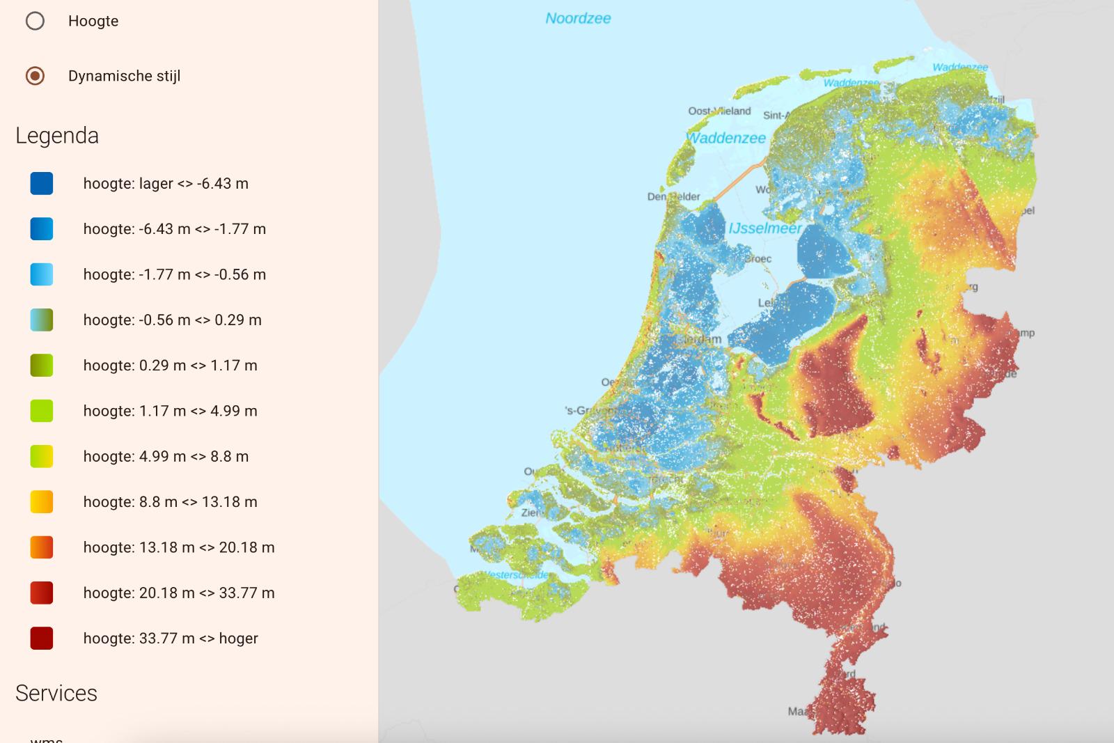
Flooded Netherlands Map without Dikes

Alex Cartwright
Senior Cartographer & GIS Specialist
Alex Cartwright is a renowned cartographer and geographic information systems specialist with over 15 years of experience in spatial analysis and data...
Geographic Analysis
What This Map Shows
This visualization presents a hypothetical scenario of the Netherlands without its extensive network of dikes and flood defenses, revealing the areas that would be submerged under water. The map highlights the elevation levels across the country, indicating how much of the land would be affected by flooding. Given that a significant portion of the Netherlands is below sea level, this visualization offers a stark reminder of the delicate balance between land and water in this country.
Deep Dive into Flooding in the Netherlands
The Netherlands is renowned for its advanced water management systems, primarily composed of dikes, sluices, and pumps. However, understanding the geography of flooding in this nation necessitates a deep dive into its hydrological features. Approximately 26% of the Netherlands lies below sea level, with some areas reaching depths of over 6 meters. These low-lying regions include the famous provinces of Zeeland and Flevoland, which would be among the first to experience flooding in the absence of dikes.
The country's intricate system of rivers, including the Rhine, Meuse, and Scheldt, plays a crucial role in its drainage. These rivers not only provide vital water resources but also pose significant flood risks, particularly during periods of heavy rainfall or snowmelt. Interestingly, the historical context of flooding has shaped the Netherlands' landscape and culture. Major flood events, such as the North Sea Flood of 1953, led to the implementation of the Delta Works, a series of dams and storm surge barriers designed to protect the land from the sea.
Moreover, the geography of the Netherlands is characterized by polders, which are tracts of land reclaimed from water bodies and protected by dikes. Without these protective barriers, the entire polder system would be at risk. For instance, the IJsselmeer polders, which include Flevoland, would be entirely submerged, highlighting the importance of these water management systems.
Flooding not only impacts the physical landscape but also has socio-economic implications. Agricultural areas, which comprise a significant portion of the Dutch economy, would face devastating losses if inundated. The fertile soils of the polders are crucial for producing crops like potatoes, sugar beets, and flowers, which contribute to the Netherlands' status as one of the world's largest exporters of agricultural products.
Regional Analysis
When analyzing the hypothetical flooding scenario by region, distinct patterns emerge. In the northern provinces, such as Friesland and Groningen, the terrain is slightly elevated compared to the central and southern regions. These areas might experience less severe flooding initially, but they still face substantial risks due to their proximity to larger water bodies. For example, the Wadden Sea's influence on tidal patterns could lead to unexpected flooding events even in areas deemed safe.
Conversely, the southern provinces, including Zeeland and South Holland, are particularly vulnerable. Zeeland, with its intricate system of islands and peninsulas, would see significant sections disappear under water, impacting local communities and ecosystems. The major cities of Rotterdam and The Hague, located in South Holland, would also face severe threats, not only from sea-level rise but also from riverine flooding due to their positions along the major waterways.
Interestingly, urban areas have developed sophisticated flood management plans, but without dikes, the effectiveness of these plans would be severely compromised. The varying elevation levels mean that towns like Delft and Leiden, located further inland, could still be impacted, showing that flooding is not just a coastal issue but a nationwide concern.
Significance and Impact
Understanding the potential flooding scenarios in the Netherlands is crucial for several reasons. Firstly, it emphasizes the importance of water management and the need for continued investment in flood defenses. Given the impacts of climate change, including rising sea levels and increased precipitation, the risk of flooding is expected to escalate.
Moreover, this topic has broader implications for global discussions on climate resilience and adaptation. Countries facing similar geographic challenges can learn from the Netherlands' approach to flood management. The advancements in technology and engineering used to create effective flood defenses serve as a model for nations worldwide.
In conclusion, the flooded Netherlands map serves as a powerful visualization of what could happen if the intricate network of dikes were removed. It not only paints a vivid picture of the land at risk but also highlights the ongoing necessity for effective water management strategies in the face of environmental changes. As global warming continues to challenge coastal nations, the Netherlands stands as a testament to both the vulnerabilities and innovations in flood management.
Visualization Details
- Published
- September 29, 2025
- Views
- 60
Comments
Loading comments...