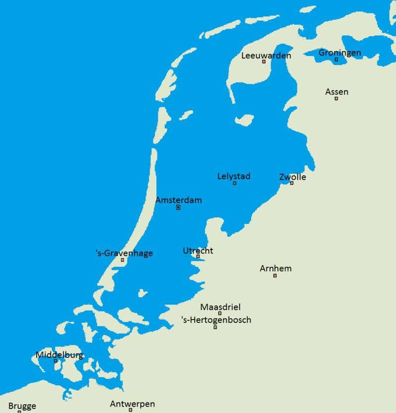
Netherlands Natural Landscape Map Without Dikes

Alex Cartwright
Senior Cartographer & GIS Specialist
Alex Cartwright is a renowned cartographer and geographic information systems specialist with over 15 years of experience in spatial analysis and data...
Geographic Analysis
What This Map Shows
This map vividly illustrates what the Netherlands might look like if dikes and other flood prevention measures had never been constructed. The visualization presents a landscape dominated by water bodies, wetlands, and an intricate network of rivers and lakes that would define the country, rather than the orderly polders and land reclamation that characterize the modern Dutch landscape. As you navigate through this map, you can imagine a Netherlands where the natural flow of water shapes the geography, creating a dynamic and ever-evolving environment.
Deep Dive into the Natural Landscape of the Netherlands
The Netherlands is famously known for its battle against the sea. With a significant portion of its land lying below sea level, the Dutch have historically found innovative solutions to manage water. However, the reality before the construction of dikes is a different story. The pre-engineered Netherlands would have been a land of extensive marshlands, estuaries, and river deltas, primarily shaped by the Rhine, Maas, and Scheldt rivers.
Understanding the natural landscape requires examining the major water systems that dominate the region. The Rhine River, one of the longest rivers in Europe, would have meandered freely, creating rich floodplains that would support diverse ecosystems. Floodplains are essential for maintaining biodiversity, providing habitat for numerous species, and acting as natural water filters. Interestingly, these floodplains would also serve as natural buffers against extreme weather events, absorbing excess rainwater and mitigating flooding risks in adjacent areas.
The Maas and Scheldt rivers would similarly carve out their paths, creating intricate delta systems that provide fertile ground for agriculture. In fact, the natural wetlands associated with these river systems would have contributed to a rich tapestry of flora and fauna, supporting bird species such as the Eurasian bittern and various migratory waterfowl. Wetlands also play a crucial role in carbon sequestration, making them vital for combating climate change.
Moreover, the absence of human interventions would have fostered a unique landscape characterized by a patchwork of ecosystems. From coastal dunes to inland lakes, the Netherlands would have been a mosaic of habitats, each contributing to the overall ecological health of the region. In addition, the natural hydrology would facilitate groundwater recharge, ensuring a sustainable water supply for both wildlife and human populations.
Regional Analysis
As we delve into specific regions of the Netherlands depicted on the map, it’s fascinating to note that the northern provinces, like Friesland and Groningen, would be dominated by vast wetlands and peat bogs, forming a crucial habitat for myriad species. The southern regions, particularly Zeeland, would showcase an intricate interplay of estuaries where the sea meets the land, creating rich brackish environments.
In contrast, the central areas, including Utrecht and North Holland, would likely be characterized by large river valleys with broad, flood-prone areas. Here, the natural flooding cycles would enrich the soil, making it exceptionally fertile for agriculture. The historical significance of agriculture in this region is profound; the fertile floodplains would have supported communities long before the current agricultural practices were developed.
Moreover, Amsterdam, currently a city known for its canals and dikes, would have emerged as a natural harbor in a complex delta system, thriving on fishing and trade rather than land reclamation. The city's unique geography would have fostered a different kind of urban development, one that prioritizes water-based transport and interaction with the natural landscape.
Significance and Impact
Understanding what the Netherlands might look like without dikes is more than just an exercise in geographical curiosity; it sheds light on the importance of water management in a changing climate. As sea levels rise and extreme weather events become more common, the lessons from this hypothetical map resonate deeply. The need for sustainable water management practices becomes increasingly critical, not only for the Netherlands but globally.
Interestingly, as cities face the challenges of urbanization and climate change, many are looking to nature-based solutions. Restoring wetlands and floodplains is gaining attention as a way to mitigate flooding while enhancing biodiversity and improving water quality. In this context, the natural landscape of the Netherlands serves as a reminder of the delicate balance between human development and environmental preservation.
Ultimately, this map prompts us to consider what our world could look like if we prioritized ecological integrity over engineered solutions. The natural landscape, rich in biodiversity and ecological functions, offers valuable insights into how we can harmonize human activity with the environment. By reflecting on the Netherlands' potential natural state, we can better appreciate the complexities of managing our waterways and the ecosystems that depend on them.
Visualization Details
- Published
- September 28, 2025
- Views
- 60
Comments
Loading comments...