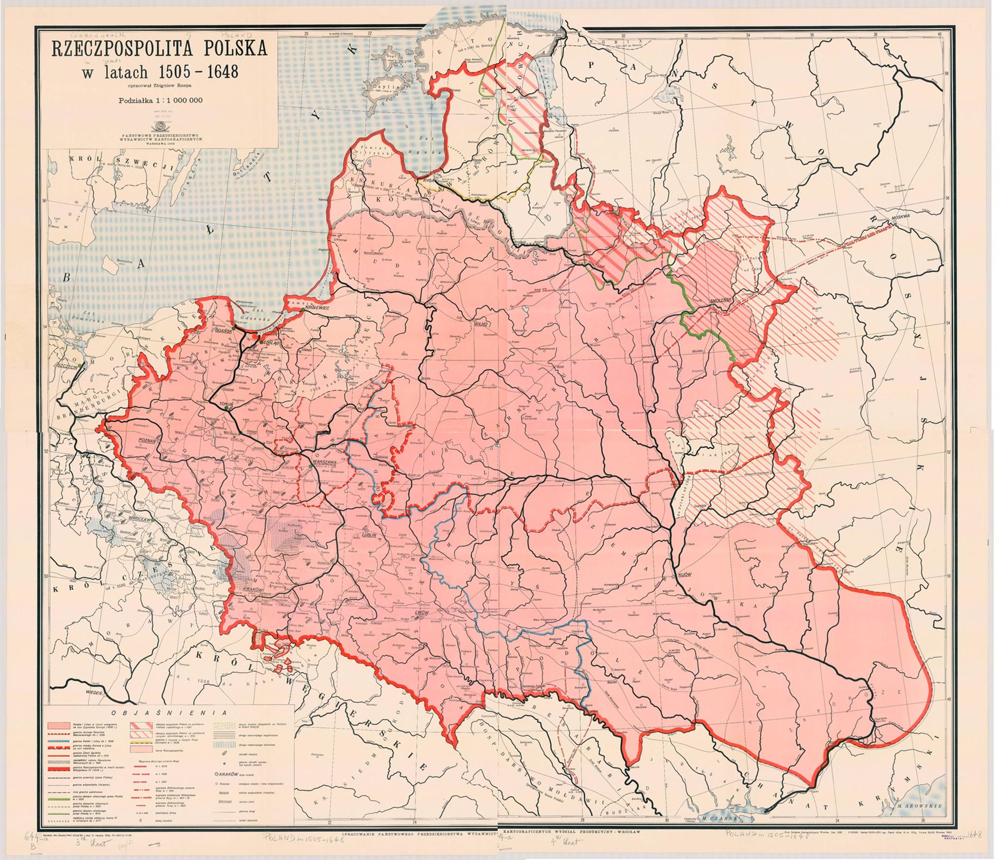
Map of the Commonwealth of Both Nations 1505-1648

Marcus Rodriguez
Historical Geography Expert
Marcus Rodriguez specializes in historical cartography and geographic data analysis. With a background in both history and geography, he brings unique...
Geographic Analysis
What This Map Shows
The "Map of the Commonwealth of Both Nations 1505-1648" illustrates the geopolitical landscape of the Polish-Lithuanian Commonwealth during a significant period in European history. This map provides insight into the territories that constituted the Commonwealth, highlighting its vastness and the diverse ethnicities and cultures that flourished within its borders. The Commonwealth was a dualistic state, formed from the union of the Kingdom of Poland and the Grand Duchy of Lithuania, and it played a crucial role in shaping the political dynamics of Eastern Europe.
Deep Dive into the Polish-Lithuanian Commonwealth
The Polish-Lithuanian Commonwealth was established in 1569 through the Union of Lublin, but its roots trace back to earlier agreements and alliances. By examining the map, we can see how the Commonwealth was not just a political union but also a melting pot of cultures, languages, and religions. It spanned a large area that included present-day Poland, Lithuania, parts of Ukraine, Belarus, and even some regions of Latvia and Estonia.
One of the most fascinating aspects of the Commonwealth was its unique governance structure, which was characterized by a system known as the "Nobles' Democracy." This meant that power was largely in the hands of the nobility, who elected the king and had significant sway over legislative matters. The map reflects this social structure by showcasing the various regions, many of which had their own local laws and customs.
What's interesting is that the Commonwealth was also notable for its religious tolerance during a time when Europe was rife with sectarian conflict. The map shows areas with diverse religious communities, including Catholics, Orthodox Christians, and Jews, coexisting under a relatively flexible legal framework. This aspect of the Commonwealth contributed to its cultural richness and economic vitality.
Economically, the Commonwealth was diverse, with agriculture being the backbone of its economy. Regions like Mazovia and Greater Poland were known for their fertile lands, producing grains and other crops that were vital for trade. The ability to engage in trade with neighboring regions and beyond was crucial, as evidenced by the numerous trade routes depicted on the map. Understanding these trade dynamics can provide insight into how the Commonwealth maintained its influence and power in a competitive European landscape.
Regional Analysis
Looking closely at the map, we can dissect the Commonwealth into its key regions, each with its own characteristics. For instance, the Crown of the Kingdom of Poland encompassed areas like Silesia and Lesser Poland, which were economically prosperous, thanks to their industrial outputs and fertile lands. In contrast, the Grand Duchy of Lithuania included vast expanses of forested areas, less populated but rich in natural resources.
Interestingly, the demographic distribution varied significantly across these regions. The western lands, closer to the borders with the Holy Roman Empire, experienced more Germanic and Latin influences, while the eastern parts were predominantly Slavic and Baltic in ethnicity. This variation influenced local governance and cultural practices, as well as trade relationships with neighboring entities.
For example, the city of Vilnius, as depicted on the map, served as a major cultural and educational center, attracting scholars and merchants from various backgrounds. Its unique position in the Commonwealth allowed it to flourish, while cities like Kraków in Poland became hubs for politics and the arts. The interplay between these urban centers is essential for understanding the Commonwealth’s overall impact during this period.
Significance and Impact
The significance of the Polish-Lithuanian Commonwealth cannot be overstated. It was one of the largest and most populous countries in 17th-century Europe, and its legacy continues to influence the political and cultural landscape of Eastern Europe today. The map serves as a reminder of a time when cooperation and coexistence were possible among diverse groups, setting a precedent for modern multicultural societies.
Currently, discussions about the Commonwealth often focus on its role in resisting external pressures from powerful neighbors such as Russia and Sweden. The historical alliances and conflicts shown on the map contribute to understanding modern national identities in these regions. Have you noticed how the borders of modern Eastern European countries often reflect historical divisions that originated in the Commonwealth?
In conclusion, the "Map of the Commonwealth of Both Nations 1505-1648" is not just a historical artifact; it is a gateway into understanding the complexities of governance, culture, and economics in a diverse landscape. As we look toward future projections, the lessons from the Commonwealth’s history prompt us to consider the importance of unity in diversity and the potential for collaboration among nations today.
Visualization Details
- Published
- September 28, 2025
- Views
- 40
Comments
Loading comments...