Air Traffic Routes Map of Washington DC and Baltimore

David Chen
Data Visualization Specialist
David Chen is an expert in transforming complex geographic datasets into compelling visual narratives. He combines his background in computer science ...
Geographic Analysis
What This Map Shows
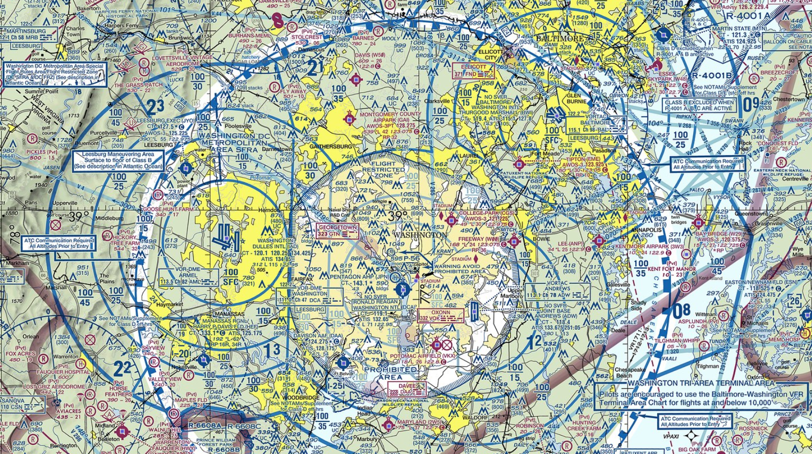
The map of Washington DC and Baltimore provides a detailed overview of air traffic routes in the region. It highlights the major airports, flight paths, and airspace classifications that facilitate the movement of aircraft between these two metropolitan areas. This visualization is essential for understanding how air travel operates within the densely populated East Coast corridor of the United States.
Air travel is a critical component of modern transportation, connecting people and businesses across vast distances. The map specifically illustrates the operational dynamics between two key cities—Washington DC, with its three major airports (Ronald Reagan Washington National Airport, Washington Dulles International Airport, and Baltimore/Washington International Thurgood Marshall Airport), and Baltimore, which predominantly relies on BWI for commercial flights. This connection not only supports business travel but also serves an enormous leisure market.
Deep Dive into Air Traffic Routes
Air traffic routes are crucial for ensuring the safety and efficiency of flight operations. The airspace over Washington DC and Baltimore is classified under various regulations due to the proximity of government buildings, making it particularly complex. The airspace is divided into several classes, ranging from Class A, which requires strict adherence to air traffic control, to Class G, where pilots operate with less oversight.
Interestingly, the area is also home to several military airspaces, which can affect commercial flight paths. For instance, the proximity to the Pentagon and various military installations necessitates flight restrictions and careful planning to avoid conflicts. This makes the air traffic management in this region a significant undertaking, involving coordination among civilian and military authorities.
The major airports play different roles in this air traffic network. Ronald Reagan Washington National Airport (DCA) is primarily focused on domestic flights, with a unique location just across the Potomac River from downtown Washington. It offers convenient access for business travelers and tourists alike. On the other hand, Washington Dulles International Airport (IAD) serves as a primary international hub, providing extensive connections to Asia, Europe, and beyond. BWI, situated closer to Baltimore, is known for its low-cost carriers and serves a diverse range of domestic and international flights.
Statistics reveal that in 2019, DCA handled over 23 million passengers, while IAD saw about 24 million, and BWI accommodated around 26 million. Post-pandemic recovery has been robust, with trends showing an increase in leisure travel, which is particularly evident at BWI, where low-cost airlines have increased their routes significantly.
Regional Analysis
When analyzing the air traffic routes between Washington DC and Baltimore, it's essential to consider the geographical and infrastructural factors that influence air travel. The map indicates that flights typically take off from one of the three major airports and may follow specific corridors to minimize congestion and ensure safety.
For instance, flights departing from DCA often follow a route that leads them over the Potomac River, providing a scenic view of the National Mall and the monuments below. In contrast, flights from IAD may take a more direct approach to bypass the densely populated areas, reducing flight time and fuel consumption.
Interestingly, BWI serves as a regional alternative for travelers seeking lower fares, often resulting in a higher volume of flights. Its location allows it to cater to both the Baltimore metropolitan area and the surrounding regions of Northern Virginia and Washington DC. As a result, BWI has become increasingly popular, leading to a more competitive atmosphere among the three airports.
Significance and Impact
Understanding the air traffic routes between Washington DC and Baltimore is not just an academic exercise; it has real-world implications for economic activity, tourism, and environmental considerations. Efficient air travel supports business operations, enhances connectivity, and promotes tourism—factors that are vital for the economic health of both cities.
Moreover, with rising concerns about climate change, the aviation industry is increasingly scrutinizing its environmental impact. The Federal Aviation Administration (FAA) and other organizations are working on initiatives to reduce carbon emissions from flights, including optimizing flight paths to minimize fuel consumption. Have you noticed the increasing emphasis on sustainability in air travel? It's a topic that will only become more significant as both cities grow.
As we look to the future, trends indicate that air travel will continue to evolve, with advancements in technology and a growing focus on sustainability. The map of air traffic routes between Washington DC and Baltimore will undoubtedly reflect these changes, illustrating a dynamic and responsive air travel network that adapts to the needs of its users.
In conclusion, the air traffic routes map of Washington DC and Baltimore is more than just a navigation tool; it represents the intricate web of connections that bind these two vibrant cities. By understanding these connections, we gain insight into the broader implications of air travel in our modern world.
Visualization Details
- Published
- September 26, 2025
- Views
- 42
Comments
Loading comments...