Geographical Map of Brazil in Europe

David Chen
Data Visualization Specialist
David Chen is an expert in transforming complex geographic datasets into compelling visual narratives. He combines his background in computer science ...
Geographic Analysis
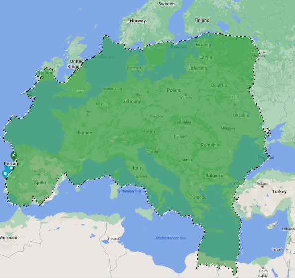
What This Map Shows
The "Brazil on Europe" map provides a unique visualization that illustrates how the land area of Brazil would fit within the geographical boundaries of Europe. This map is not merely a playful representation; it serves to highlight the vast size of Brazil compared to European nations. By overlaying Brazil onto the European continent, we can gain insights into Brazil's area in relation to various countries and regions in Europe, prompting discussions about land use, population density, and cultural comparisons.
Deep Dive into Land Area Comparisons
Brazil, the largest country in South America, covers an impressive land area of approximately 8.5 million square kilometers. In contrast, the entire European continent, which encompasses around 10.18 million square kilometers, hosts a diverse array of countries, each with its own geographical features, cultures, and histories.
Interestingly, when we place Brazil on top of Europe, it becomes evident that it could stretch from the westernmost point of Portugal to the eastern borders of Romania. This comparison leads us to consider how land area influences various geographical and socio-economic factors. For instance, a larger land area often allows for greater agricultural production, diverse ecosystems, and varied climates. Brazil, with its diverse landscapes ranging from the Amazon rainforest to the Pantanal wetlands, showcases a wealth of biodiversity that is unmatched in Europe.
Additionally, the population density in Brazil is markedly different from that of Europe. With a population of around 213 million people, Brazil experiences significant urbanization, with large cities like São Paulo and Rio de Janeiro housing millions. In Europe, cities like London, Paris, and Berlin are also densely populated, but the scale and distribution of population across countries are more varied. This map invites us to reflect on urban development patterns in both regions, considering how geography shapes human settlement and vice versa.
Regional Analysis
Examining specific areas, when Brazil is overlaid upon countries like France or Germany, we see that Brazil could encompass these nations entirely. For instance, France's land area is about 551,695 square kilometers, meaning Brazil could fit into France multiple times. This stark contrast highlights how smaller European nations, like Luxembourg or Malta, might fit into even a fraction of the Brazilian territory.
Moreover, if we look at specific regions within Brazil, such as the Amazon, which covers 5.5 million square kilometers alone, it's fascinating to see how this single region could encompass several European countries combined. The Amazon rainforest is not only vital for biodiversity but also plays a crucial role in regulating the Earth's climate. In stark comparison, European countries face different environmental challenges, such as urban sprawl and pollution, which are shaped by their geographical constraints.
Significance and Impact
Understanding the geographical scale of Brazil in relation to Europe has broader implications in the context of global environmental issues, trade, and cultural exchanges. For instance, Brazil's vast natural resources, including vast forests and mineral wealth, are essential for international markets. This map can help raise awareness about the importance of preserving Brazil's ecosystems, especially when considering Europe's significant reliance on these resources.
Furthermore, with the ongoing climate crisis, the interactions between Brazil's environment and Europe’s policy decisions become crucial. Brazil’s role in global agriculture, particularly with products like soy and beef, has direct implications for deforestation rates in the Amazon, which the European Union is increasingly focused on regulating through trade policies.
As we consider future projections, it is clear that the geographical positioning of Brazil and its vast resources will continue to play a significant role in international relations, environmental sustainability efforts, and economic partnerships. Understanding this map allows us to appreciate the connections between geographical size, resource management, and socio-economic dynamics in a global context.
In conclusion, the "Brazil on Europe" map not only provides a visual representation of land area but also serves as a springboard for deeper discussions about geography and its implications on human life and the environment. Through maps like this, we can better appreciate our world, the challenges we face, and the interconnectedness of different regions.
Visualization Details
- Published
- September 24, 2025
- Views
- 46
Comments
Loading comments...