Germanic Tribes Map of France and Iberia (500 AD)

Alex Cartwright
Senior Cartographer & GIS Specialist
Alex Cartwright is a renowned cartographer and geographic information systems specialist with over 15 years of experience in spatial analysis and data...
Geographic Analysis
What This Map Shows
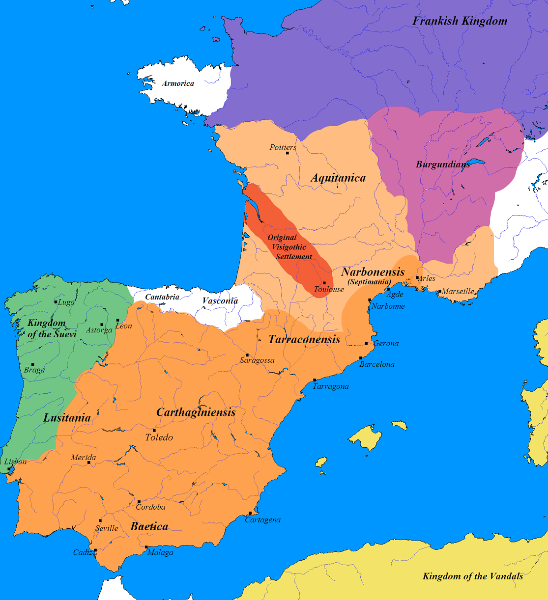
The map titled "Germanic France and Iberia (500 AD)" provides a fascinating glimpse into the landscape of post-Roman Europe, specifically focusing on the territories occupied by Germanic tribes during this transformative period. The visual representation highlights the territories controlled primarily by the Franks in what is modern-day France and the Visigoths in Spain and Portugal. Following the decline of the Roman Empire, these tribes filled the power vacuum, reshaping the political and cultural landscape of Western Europe.
Deep Dive into Germanic Tribes and Their Territories
The Germanic tribes were a collection of ethnic groups who spoke Germanic languages and shared certain cultural traits. By 500 AD, two of the most significant tribes emerged as dominant forces in Western Europe: the Franks and the Visigoths. The Franks, who would eventually lay the groundwork for modern France, were known for their military prowess and organizational skills. Led by figures such as Clovis I, they began to unify various factions under a single banner, establishing a stronghold in northern and central France.
Interestingly, the Germanic tribes didn't just conquer; they also assimilated various aspects of Roman culture, including governance, law, and infrastructure. This blending of cultures is particularly evident in the territories they occupied. For example, in regions that were once part of Roman Gaul, the Franks adopted Roman administrative practices while imposing their own tribal laws. This resulted in a unique fusion that would shape the future of French identity.
On the other hand, the Visigoths, who settled primarily in the Iberian Peninsula, were instrumental in the transition from Roman to medieval society in what is now Spain and Portugal. They established a kingdom with Toledo as its capital, which became an important cultural and political center. The Visigoths also contributed to the evolution of the Spanish language and the Christianization of the region, marking a significant shift in cultural and religious practices.
The map itself reflects these territorial distinctions, with distinct areas marked for the Franks and the Visigoths, showcasing how the balance of power shifted in the wake of Rome's fall. The territories occupied by these tribes were not merely geographical boundaries; they represented the beginning of new political entities and the decline of Roman influence.
Regional Analysis
In examining the map, we can see clear distinctions between the regions dominated by the Franks and those controlled by the Visigoths. The Frankish territories largely encompassed northern and central France, while the Visigothic regions extended into the Iberian Peninsula. Each area displayed its own unique characteristics and influences.
For instance, the Frankish region, particularly around Paris and the Loire Valley, was known for its fertile lands and strategic river systems, which facilitated trade and movement. This agricultural wealth would later support the growing Frankish state, allowing it to flourish economically.
Contrastingly, in the Iberian Peninsula, the Visigoths faced a different set of challenges and opportunities. The rugged terrain of the region, along with its diverse climates, prompted the Visigoths to adapt their practices. They developed a network of fortified cities to defend against both internal strife and external threats, such as the rising power of the Muslim Umayyads.
Notably, the cultural integration of the Visigoths was also profound. They embraced local customs, intermarried with the Roman populace, and laid down legal codes that influenced later Spanish law. This cultural synthesis can be traced through the evolution of language and tradition, which still resonate today in modern Spain.
Significance and Impact
The establishment of territories by the Germanic tribes in France and Iberia marked a pivotal moment in European history, setting the stage for the development of modern nations. The power dynamics during this period influenced not only the political landscape but also social structures, economic practices, and cultural identities that would persist for centuries.
What's fascinating is how these early Germanic kingdoms laid the groundwork for future European unification and conflict. The legacy of the Franks and Visigoths can be seen in the rise of medieval empires, the spread of Christianity across Europe, and the eventual formation of nation-states.
As we look at current trends, understanding the historical context of these regions helps us appreciate how deeply rooted cultural identities have evolved. Today, France and Spain are distinct nations, yet remnants of their Germanic past continue to shape their identities and interactions. The historical map serves not just as a record of territorial claims but as a reminder of the dynamic and often tumultuous history that has forged modern Europe.
In conclusion, the Germanic tribes of 500 AD were not mere invaders; they were crucial architects of a new European order. Their legacies continue to influence contemporary society, making the study of this map essential for anyone interested in the historical geography of Europe.
Visualization Details
- Published
- September 21, 2025
- Views
- 76
Comments
Loading comments...