West Bank Proposed Annexation Map: Bantustans

Alex Cartwright
Senior Cartographer & GIS Specialist
Alex Cartwright is a renowned cartographer and geographic information systems specialist with over 15 years of experience in spatial analysis and data...
Geographic Analysis
What This Map Shows
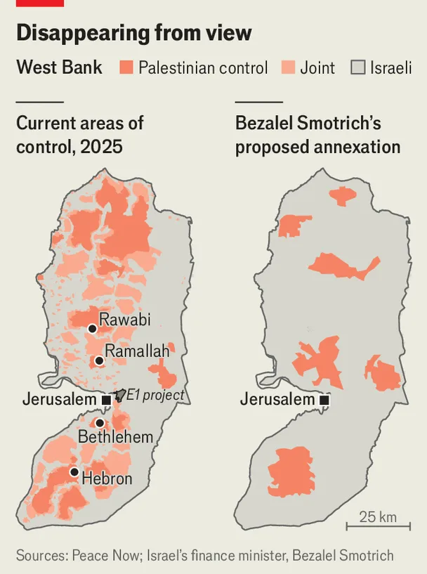
The West Bank Proposed Annexation Map: Bantustans visualization showcases the complex geopolitical landscape of the West Bank, highlighting areas that are proposed for annexation and the corresponding division of territories. This map serves as a critical tool for understanding how proposed changes could affect the demographics, governance, and socio-economic dynamics in this contentious region.
Deep Dive into Bantustans
The term "Bantustan" originated in South Africa during the apartheid era, referring to territories set aside for Black inhabitants. These areas were often characterized by limited economic opportunities and harsh governance, and they were strategically designed to limit the political power of their residents. In the context of the West Bank, the proposed annexation zones can similarly be viewed through the lens of territorial fragmentation.
What's fascinating is how the concept of Bantustans applies to the ongoing Israeli-Palestinian conflict. The proposed annexation areas on the map generally align with the existing Israeli settlements, which have expanded significantly over the past few decades. The Israeli government views these settlements as vital for security and historical claims, while Palestinians see them as encroachments on their future state.
As of recent estimates, approximately 2.8 million Palestinians live in the West Bank, alongside around 600,000 Israeli settlers. The demographic distribution is crucial; it not only shapes the political landscape but also influences economic interactions, cultural exchanges, and daily life. The map illustrates how annexation could further isolate Palestinian communities, potentially relegating them to enclaves that lack essential resources and governance.
These Bantustan-like territories would likely have limited access to key infrastructure, such as roads and water supply, exacerbating the challenges faced by Palestinians. For example, access to East Jerusalem, a significant economic and cultural center for Palestinians, could become even more restricted, leading to increased economic disparity and social unrest.
Regional Analysis
The West Bank is subdivided into various regions, each with unique characteristics and challenges. For instance, the northern part, including cities like Jenin and Nablus, tends to have a higher density of Palestinian population and a more pronounced resistance to Israeli policies. In contrast, the southern areas, such as Hebron, represent a mix of Palestinian and Israeli settlements, complicating the social fabric further.
Interestingly, the proposed annexation map reveals that certain areas, like Area C, which is under full Israeli military control, are poised to be annexed entirely. In contrast, Areas A and B, where Palestinian Authority has varying degrees of control, could see their borders redrawn significantly, leading to further fragmentation.
Comparing the proposed annexation zones shows a stark contrast in land use and available resources. For instance, areas with high agricultural potential may be annexed, while urban centers might remain intact, leading to a scenario where agricultural communities become isolated, lacking access to markets and essential services. This territorial fragmentation will not only impact the economy but also the cultural and social cohesion of Palestinian communities.
Significance and Impact
The implications of this proposed annexation are profound and multifaceted. Understanding the geographical and political nuances of this map is crucial for grasping the broader implications of Israeli-Palestinian relations. The potential establishment of Bantustan-like territories raises questions about the viability of a future Palestinian state. It reflects ongoing struggles over land, identity, and rights that have persisted for decades.
As political developments unfold, one cannot help but wonder how these territorial changes might affect international relations in the region. Countries that have historically supported Palestinian statehood may find themselves reevaluating their positions in light of these changes. Moreover, the internal dynamics within Palestinian territories could shift dramatically, affecting everything from local governance to grassroots activism.
In conclusion, the West Bank Proposed Annexation Map: Bantustans not only serves as a cartographic representation of proposed geopolitical changes but also embodies the deep-seated conflicts and aspirations of the Palestinian people. As we analyze this map and its implications, we must remain vigilant about the ongoing struggles for justice, equality, and self-determination in this historically rich yet contested region.
Visualization Details
- Published
- September 21, 2025
- Views
- 52
Comments
Loading comments...