ZIP Code Zones of the United States Map

Alex Cartwright
Senior Cartographer & GIS Specialist
Alex Cartwright is a renowned cartographer and geographic information systems specialist with over 15 years of experience in spatial analysis and data...
Geographic Analysis
What This Map Shows
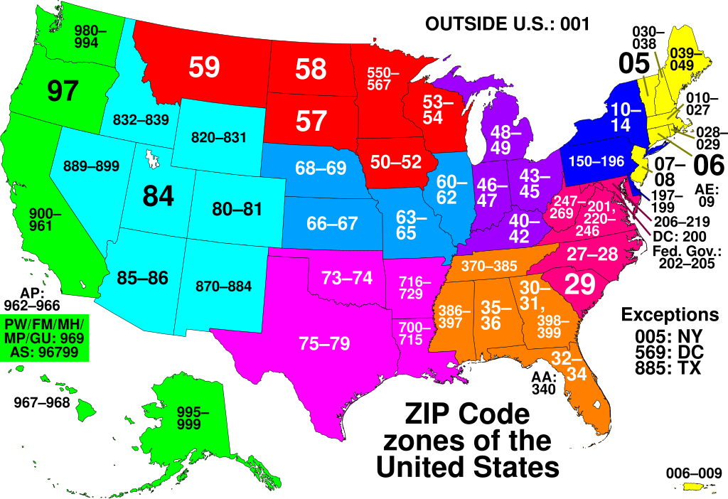
The "ZIP Code Zones of the United States" map visually represents the postal code system that divides the U.S. into specific geographic areas for efficient mail delivery. Each ZIP Code, which stands for Zone Improvement Plan, is a unique identifier that helps streamline the postal process. In this map, colors and boundaries delineate the various ZIP Code zones, offering a clear view of how these areas are organized across the country. This map is not just a tool for postal services; it reflects population density, urban vs. rural distinctions, and even socio-economic trends.
Deep Dive into ZIP Codes
Ever wondered why ZIP Codes are so crucial in our daily lives? Beyond their primary role in mail delivery, they serve as an essential tool for demographic analysis, marketing, and urban planning. The U.S. ZIP Code system was introduced in 1963 and has evolved significantly since then. Each code is made up of five digits, with the first digit representing a group of U.S. states, and subsequent digits narrowing down to specific regions, cities, or neighborhoods.
Interestingly, ZIP Codes are closely associated with population density. For instance, urban areas often have smaller ZIP Code zones due to high population concentration. In contrast, rural areas might cover larger geographic expanses with fewer residents. Did you know that New York City has over 200 unique ZIP Codes? This density highlights the complexity of urban living and the need for precise postal routes.
However, ZIP Codes also reveal socio-economic patterns. Areas with high-income households may have ZIP Codes that correlate with higher property values, while lower-income neighborhoods might share a different set of codes. This socio-economic divide can impact everything from school funding to healthcare access. According to the U.S. Census Bureau, the median household income can vary significantly by ZIP Code, reflecting the disparities present in American society.
Moreover, ZIP Codes are increasingly used in data analysis for businesses looking to target marketing efforts. Companies can analyze consumer behavior based on ZIP Code demographics, tailoring their products and services to meet the needs of specific communities. This information can influence everything from advertising strategies to service availability.
Regional Analysis
When looking at the ZIP Code zones across the United States, it's fascinating to see the regional differences that emerge. For example, in the Northeast, areas like Manhattan and Brooklyn have a dense cluster of ZIP Codes reflecting their high population density. In contrast, rural areas in states like Wyoming or Montana have expansive ZIP Code zones with much larger geographic coverage and fewer people.
If we shift our focus to the South, ZIP Codes often reflect a mix of urban and suburban areas. Cities like Atlanta have a wide range of ZIP Codes that can vary dramatically in terms of socio-economic status. For instance, the differences between the affluent neighborhoods in Buckhead and the more economically challenged areas in South Atlanta are stark but can be traced back to their respective ZIP Codes.
In the Midwest, areas like Chicago demonstrate a similar pattern, where the ZIP Code map reveals both affluent suburbs and urban areas battling economic challenges. Have you noticed how ZIP Codes can often serve as a proxy for understanding regional identity? They tell us not just where we live but also the characteristics of our communities.
Significance and Impact
Understanding ZIP Code zones is essential for various reasons. As mentioned, they play a crucial role in mail delivery, but their implications extend far beyond that. For instance, during elections, ZIP Codes can help determine voting patterns and demographic shifts, influencing political representation. Furthermore, public health initiatives often target specific ZIP Codes to address health disparities, showcasing the importance of this geographic information.
Looking toward the future, the role of ZIP Codes may evolve with advancements in technology and changes in population dynamics. With the rise of remote work, for example, how will the traditional ZIP Code model adapt to shifting populations? As more people move to suburban or rural areas, we might see changes in how ZIP Codes are assigned and utilized.
In conclusion, while ZIP Codes might seem like a mundane aspect of our everyday lives, their significance is vast and multifaceted. They encapsulate the essence of communities, influencing everything from mail delivery to socio-economic conditions. Understanding this map can help us appreciate the intricate tapestry of American society and the geographical patterns that define it.
Visualization Details
- Published
- September 19, 2025
- Views
- 54
Comments
Loading comments...