Concentration Camp and Execution Camp Map of Nazi Germany

Marcus Rodriguez
Historical Geography Expert
Marcus Rodriguez specializes in historical cartography and geographic data analysis. With a background in both history and geography, he brings unique...
Geographic Analysis
What This Map Shows
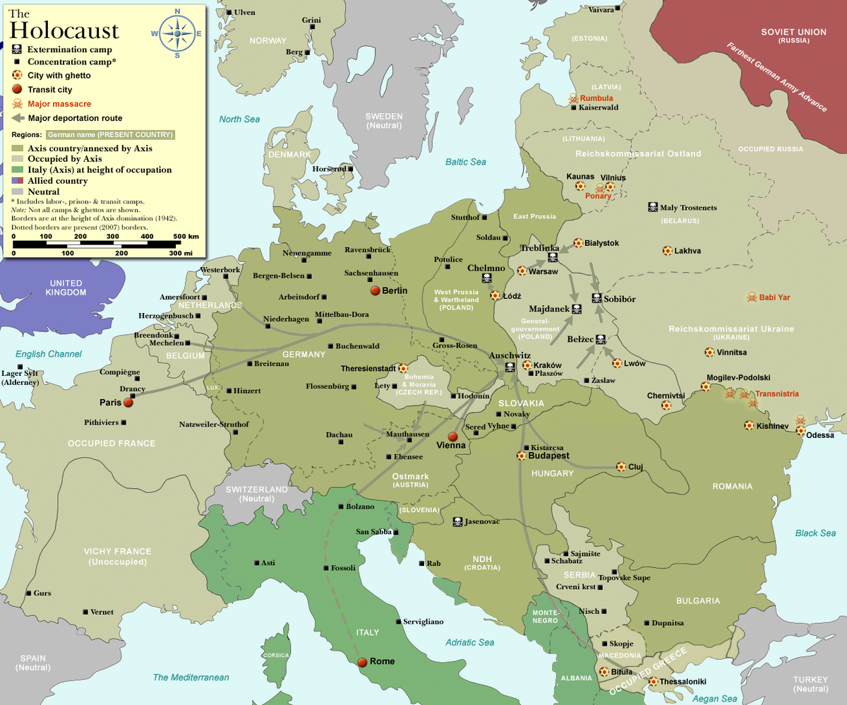
The map titled "Concentration Camp and Execution Camp Map of Nazi Germany" illustrates the locations and distribution of concentration camps and execution sites established during the Nazi regime from the 1930s to 1945. This visualization serves as a stark reminder of the extensive network of camps where millions of individuals suffered and perished under the horrific policies of the Third Reich. By pinpointing the locations of these camps, the map highlights not only the geographical spread of the Nazi's oppressive system but also the staggering scale of human rights violations that occurred throughout Europe during this dark period in history.
Deep Dive into Concentration and Execution Camps
Concentration camps were primarily used for the detention of political prisoners, Jews, Roma, homosexuals, and other groups deemed undesirable by the Nazi regime. The camps were established in various locations across Germany and occupied territories, with Auschwitz, Dachau, and Bergen-Belsen being among the most notorious. Interestingly, the term "concentration camp" refers to facilities where individuals were held under harsh conditions, often subjected to forced labor, starvation, and brutal treatment.
Execution camps, on the other hand, were specifically designed for systematic mass murder. Facilities like Sobibor, Treblinka, and Belzec were part of the Operation Reinhard, which aimed to exterminate the Jewish population of Eastern Europe. These sites were equipped with gas chambers and other means of mass execution, leading to the deaths of countless individuals in a matter of months. The use of technology and industrial methods for such inhumane purposes is both shocking and deeply troubling.
The geographical layout of these camps reveals a chilling pattern. Many camps were located near rail networks, enabling the Nazis to transport victims efficiently. For instance, Auschwitz, located near the rail hub of Oswiecim, was a significant point of arrival for deportees from across Europe. The map allows us to see how the Nazis strategically placed these camps in relation to transportation routes and urban centers, maximizing their ability to carry out their genocidal agenda.
The scale of suffering in these camps is staggering. By the end of World War II, it is estimated that around six million Jews and millions of others, including Soviet prisoners of war and political dissidents, lost their lives as a direct result of Nazi policies. The map serves as a powerful reminder of this tragic history, prompting reflection on the importance of remembering and educating future generations about the atrocities committed during this period.
Regional Analysis
Breaking down the concentration and execution camps by region reveals significant variations in the number and type of facilities. For example, in Germany, the concentration camps were often located in rural areas, where they operated in secrecy. In contrast, in occupied Poland, where extermination camps were prevalent, the camps were strategically situated to facilitate mass killings. Interestingly, the sheer number of camps in Eastern Europe often overwhelms the historical narrative, overshadowing the equally tragic experiences in Germany.
Looking at specific examples, Auschwitz in Poland operated not only as a concentration camp but also as an extermination camp, illustrating a dual purpose that was tragically effective. Meanwhile, Dachau, one of the first concentration camps established, became a model for future camps and played a pivotal role in the Nazi system, housing political prisoners and later Jews and other groups. The geographical concentration of these camps in certain areas also reflects the Nazis' ideologies, as they sought to eliminate perceived threats to their regime.
Significance and Impact
The significance of the map goes beyond merely showcasing locations; it serves as a historical record of human rights abuses that should never be forgotten. Understanding where these camps were located and their function helps to contextualize the scale of the Holocaust and the impact of Nazi policies on millions of lives. Moreover, it prompts critical discussions about morality, human rights, and the importance of standing against oppression in all forms.
In today's world, the lessons from this dark chapter in history remain relevant. As we witness rising instances of hate and intolerance, the map serves as a crucial reminder of the need for vigilance against ideologies that promote division and violence. The historical knowledge gained from studying concentration and execution camps can inform current debates surrounding refugee crises, discrimination, and human rights. This map, therefore, is not just a geographical tool; it is a call to action to ensure that such atrocities are never repeated.
In conclusion, the Concentration Camp and Execution Camp Map of Nazi Germany is a powerful visual representation of one of history's most horrific chapters. By understanding the geographical context of these camps, we can better comprehend the magnitude of the suffering endured and the importance of preserving historical memory.
Visualization Details
- Published
- September 18, 2025
- Views
- 64
Comments
Loading comments...