Torres Strait Islands Map of Australia

David Chen
Data Visualization Specialist
David Chen is an expert in transforming complex geographic datasets into compelling visual narratives. He combines his background in computer science ...
Geographic Analysis
What This Map Shows
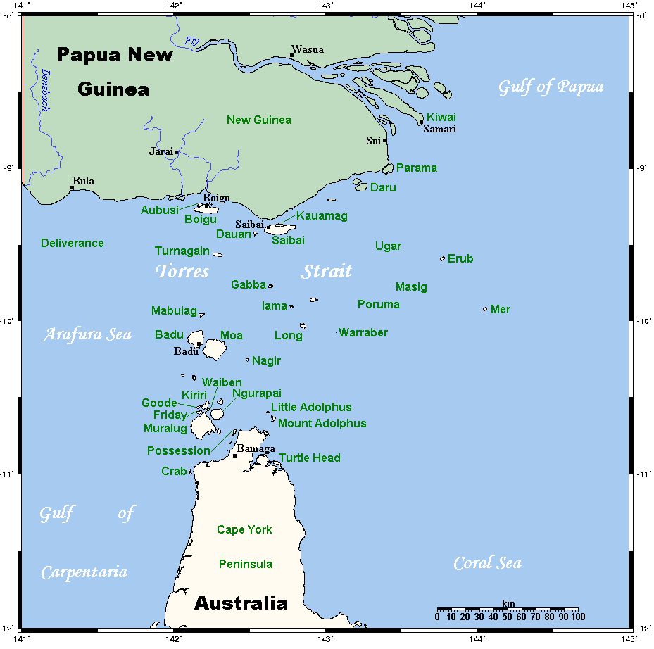
The map of the Torres Strait Islands illustrates a unique geographical area situated between the Australian mainland and Papua New Guinea. This collection of over 274 islands, islets, and cays showcases a mix of landscapes, cultures, and ecosystems that are both diverse and significant. The islands are divided into two main groups: the Eastern Islands, which are closer to Papua New Guinea, and the Western Islands, which are nearer to Australia. Each island has its own distinct features, ranging from lush tropical vegetation to rugged coastlines.
Deep Dive into the Torres Strait Islands
The Torres Strait Islands are not just a geographical boundary; they are a vibrant cultural mosaic inhabited predominantly by Torres Strait Islanders, who maintain a rich cultural heritage distinct from that of mainland Australians. The islands are known for their unique languages, traditions, and practices, often centered around fishing and maritime activities, which are integral to their way of life. The environment of the Torres Strait is characterized by a tropical climate, with warm temperatures and significant rainfall, supporting an array of flora and fauna.
Interestingly, the region is home to some of the most biodiverse marine ecosystems in the world. The waters surrounding the islands host extensive coral reefs, seagrass beds, and mangrove forests, which are crucial for both the local economy and environmental health. The Great Barrier Reef lies to the south of the Torres Strait, enhancing the ecological significance of this region.
One of the remarkable aspects of the Torres Strait Islands is the traditional land management practices of the Islanders. They have a deep understanding of their environment, employing sustainable practices that have been passed down through generations. For example, traditional fishing techniques are designed to maintain fish populations, ensuring that the local resources are not overexploited. As a result, the islands have retained a level of ecological integrity that many other regions have lost.
Regional Analysis
When examining the map closely, we can break down the Torres Strait Islands into distinct regions. The Eastern Islands, such as Badu, Moa, and Mabuiag, often have populations that engage in agricultural activities alongside their traditional fishing practices. In contrast, the Western Islands, including Thursday Island and Horn Island, serve as administrative centers and have more developed infrastructure, which attracts tourism and facilitates trade.
For instance, Thursday Island boasts a rich history as a former pearling hub, and today it is a vibrant community that offers insights into the cultural heritage of the Torres Strait Islanders. The differences in economic activities among the islands create a varied demographic landscape, where some islands are more densely populated and economically developed than others. For example, the population of Thursday Island is significantly higher than that of smaller islands like Kubin or St. Pauls, which have fewer resources and a more traditional lifestyle.
Significance and Impact
Understanding the geography and culture of the Torres Strait Islands is essential for several reasons. Firstly, it highlights the importance of preserving the unique cultural identities and practices of the Torres Strait Islanders, especially in the face of modern challenges such as climate change. Rising sea levels pose a significant threat to the low-lying islands, and addressing these issues requires an inclusive approach that considers the voices of the local communities.
Moreover, the ecological health of the Torres Strait is vital not just for the Islanders but for global biodiversity. The region's coral reefs and marine life are increasingly under threat from climate change, overfishing, and pollution. Efforts to protect this environment are crucial, not only for the sustainability of local communities but also for maintaining the health of the broader marine ecosystem.
In conclusion, the map of the Torres Strait Islands is more than just a representation of geography; it encapsulates a complex interplay of culture, environment, and economy. As we move forward, recognizing the significance of these islands and their peoples will be key in ensuring their survival and prosperity in an ever-changing world.
Visualization Details
- Published
- September 17, 2025
- Views
- 90
Comments
Loading comments...