Post-War Occupation Division of Germany Map

Alex Cartwright
Senior Cartographer & GIS Specialist
Alex Cartwright is a renowned cartographer and geographic information systems specialist with over 15 years of experience in spatial analysis and data...
Geographic Analysis
What This Map Shows
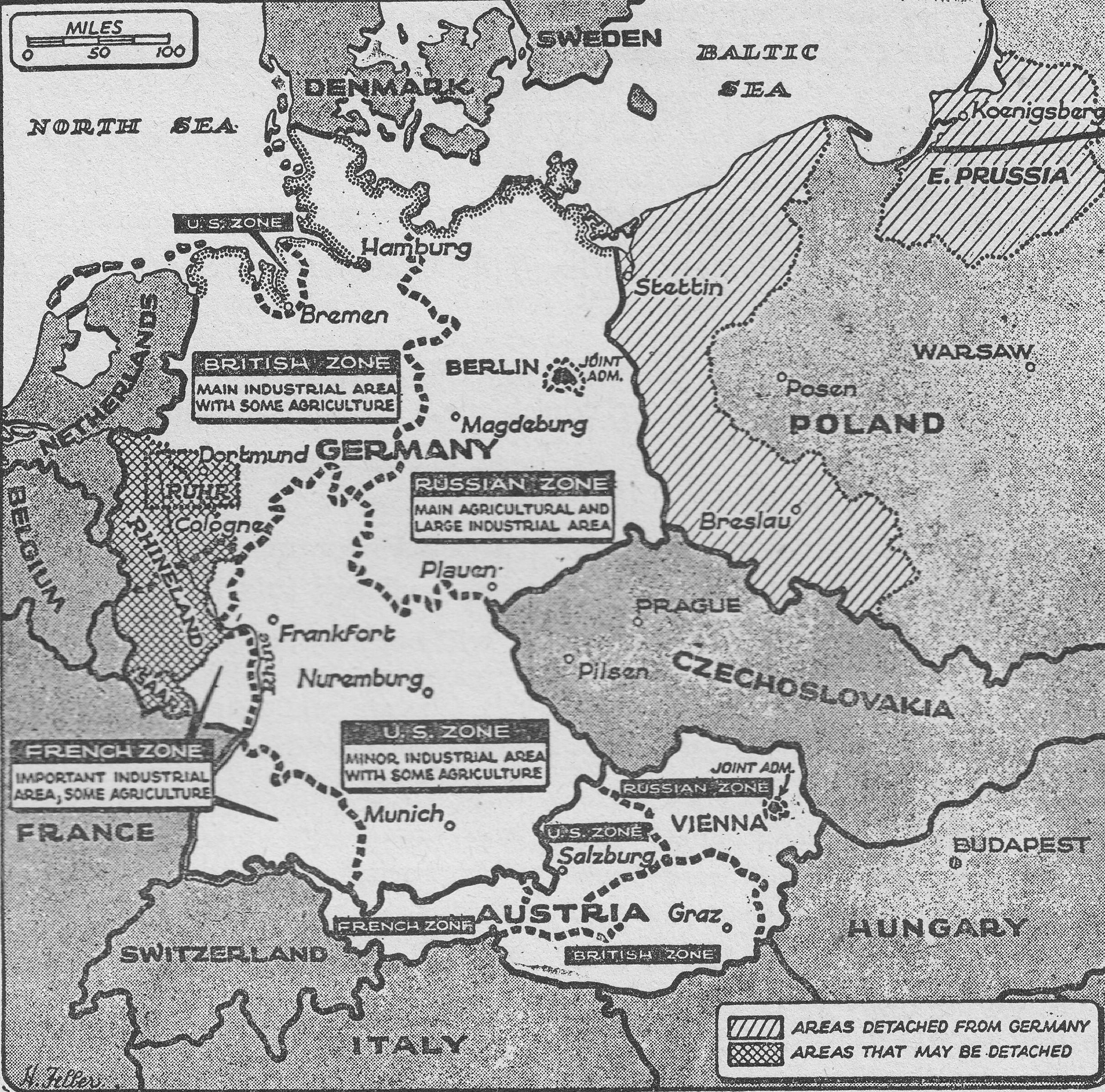
The "Post-War Occupation Division of Germany (1948) Map" vividly illustrates the geographical demarcation of Germany into four distinct occupation zones following World War II. Each zone was controlled by one of the Allied powers: the United States, the United Kingdom, France, and the Soviet Union. This map not only highlights the geopolitical landscape of the time but also sets the stage for significant events that would shape the future of Germany and Europe.
Deep Dive into Post-War Occupation Zones
The aftermath of World War II left Germany in a state of disarray. The map illustrates how the Allied powers divided the nation in 1948, creating zones of influence that would ultimately reflect their differing ideologies and objectives. The United States, United Kingdom, and France established their zones in the west, while the Soviet Union took control of the eastern part of the country.
Interestingly, this division was not merely a military strategy; it was also a socio-economic initiative. The introduction of the Deutschmark in the western zones in June 1948 marked a significant turning point. This new currency was designed to stabilize the economy and curb rampant inflation that had plagued Germany in the post-war years. The initial printing of this currency took place in the United States, showcasing the depth of American involvement in the economic reconstruction of West Germany.
The western zones, known as the Trizonia (a combination of the three western zones), began to experience economic revitalization, leading to what is known as the "Wirtschaftswunder" or economic miracle. This period saw rapid industrial growth, increased employment, and a significant improvement in living standards. In contrast, the eastern zone, under Soviet control, struggled with economic hardship and political repression, laying the groundwork for the later division of Germany into East and West.
The division of Germany was not only political and economic; it also had profound cultural implications. Families were split, and lifelong friendships were severed, leading to a generation of Germans who would grow up in a divided nation. The visual representation of these zones on the map serves as a stark reminder of the human cost of geopolitical decisions.
Regional Analysis
Examining the map reveals distinct differences between the occupation zones. The American zone, primarily encompassing Bavaria and parts of Hesse and Baden-Württemberg, became a hub for economic growth. Cities like Munich and Stuttgart flourished, benefiting from American investments and the Marshall Plan, which aimed to rebuild war-torn Europe.
On the other hand, the British zone, which included North Rhine-Westphalia and parts of Lower Saxony, experienced its own set of challenges. While cities like Hamburg and Bremen maintained their significance, the region faced industrial decline in some areas, particularly those reliant on coal and steel production.
The French zone, located in the southwest, was smaller and less economically robust compared to its American and British counterparts. However, cities like Stuttgart and Freiburg developed a unique cultural identity, heavily influenced by French culture and governance. In contrast, the Soviet zone, encompassing East Berlin and surrounding areas, was marked by economic stagnation and a centralized, state-controlled economy that stifled individual freedoms and entrepreneurship.
Significance and Impact
The division of Germany as depicted on this map is significant for several reasons. It not only underscores the immediate post-war geopolitical realities but also foreshadows the Cold War's ideological battle between East and West. The contrasting experiences of the German people in the two zones would lead to a deep-seated rivalry that would last for decades.
In contemporary terms, the legacy of this division is still felt. The Berlin Wall, erected in 1961, became a powerful symbol of this ideological divide, and the reunification of Germany in 1990 marked a turning point in European history. Today, as we look back on the post-war occupation, it’s essential to recognize how these historical divisions have shaped modern Germany's political landscape and identity. As we navigate the complexities of international relations today, the lessons from this map remind us of the importance of diplomacy, cooperation, and the shared desire for peace among nations.
In conclusion, the "Post-War Occupation Division of Germany (1948) Map" serves as a crucial historical document. It encapsulates a pivotal moment in time that influenced not just Germany but the entire European continent, illustrating the fragility of peace and the enduring impact of war.
Visualization Details
- Published
- September 15, 2025
- Views
- 60
Comments
Loading comments...