Greater Denmark Alternate History Map

Marcus Rodriguez
Historical Geography Expert
Marcus Rodriguez specializes in historical cartography and geographic data analysis. With a background in both history and geography, he brings unique...
Geographic Analysis
What This Map Shows
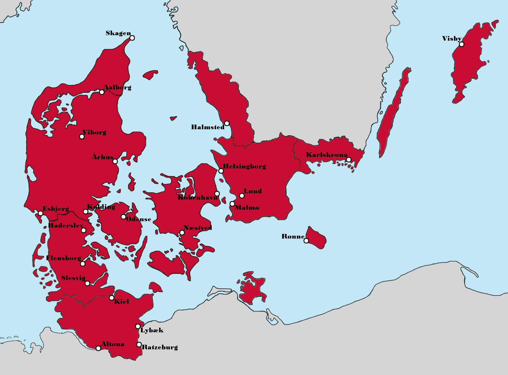
The 'Greater Denmark (Alternate History)' map presents a fascinating reimagining of the Nordic region, highlighting a scenario where Denmark extends its influence and territory beyond its current borders. In this visualization, we see not only the traditional boundaries of Denmark but also the territories of Northern Germany, parts of southern Sweden, and even Iceland, all of which are depicted as part of an expanded Danish realm. This alternate history invites us to consider the geopolitical, cultural, and economic implications of such a scenario, setting the stage for a deeper exploration of the historical context and the dynamics of territorial expansion in Scandinavia.
Deep Dive into Greater Denmark
To understand the significance of this alternate history map, we must delve into the rich tapestry of history that has shaped Denmark and its surrounding regions. Denmark has long been a significant player in Northern European history, particularly during the Viking Age (circa 793-1066 AD), when Danish seafarers and warriors expanded their reach across vast territories, including parts of England, Ireland, and even into the Mediterranean. The Viking influence laid the groundwork for the cultural and political landscapes of the regions they encountered.
What’s fascinating is that the concept of Greater Denmark isn't just a whimsical thought experiment; it draws on real historical ambitions. The Kalmar Union (1397-1523) was an early attempt to unite the crowns of Denmark, Sweden, and Norway under a single monarch, showcasing Denmark's aspirations to be a dominant power in Scandinavia. In this alternate history, we can imagine what might have happened if the Kalmar Union had succeeded in maintaining its unity and expanded its influence further into German territories.
Economically, a Greater Denmark could have shifted trade routes and patterns significantly. The Baltic Sea, already a crucial maritime corridor, would likely have become even more central to the economic activities of a consolidated Danish empire. The cities of Lübeck and Hamburg, key players in the Hanseatic League, might have found themselves under Danish control, altering the very nature of trade in Northern Europe.
Demographically, the concept of a Greater Denmark raises intriguing questions about cultural integration and conflicts. Would the distinct identities of the German and Swedish populations blend seamlessly into a Danish identity, or would there be resistance and strife? The Danish language and culture would likely spread, but how would this affect the rich tapestry of local traditions? The map encourages us to ponder these possibilities, highlighting the complexities of identity in an alternate reality.
Regional Analysis
Looking at the regions depicted in the map, we can break down the implications of a Greater Denmark by examining the historical and cultural contexts of each area. For instance, in northern Germany, cities like Flensburg and Kiel would have been integrated into a Danish cultural framework, potentially leading to a unique blend of Danish and German customs. The historical ties between Denmark and Schleswig-Holstein provide a real-world parallel; this area has oscillated between Danish and German control throughout history.
In contrast, the incorporation of southern Sweden into Greater Denmark would have profound effects on regional dynamics. Historically, Sweden was a rival power to Denmark, especially during the 17th century, when wars over control of territories were common. A Greater Denmark could have altered the trajectory of Swedish independence movements and might have even changed the outcome of conflicts like the Great Northern War (1700-1721).
Furthermore, including Iceland and Greenland in this alternate map suggests a more centralized control over the North Atlantic territories, potentially enhancing Denmark's strategic military and trade capabilities. The fishing industries, critical to the economies of these regions, would likely have flourished under a unified governance, reflecting a thriving maritime culture.
Significance and Impact
The topic of Greater Denmark holds significant implications for understanding historical narratives and geopolitical relationships in Northern Europe. It encourages us to consider how borders define not just geography but also identity and culture. The map serves as a reminder of the fluid nature of nation-states and the historical legacies that continue to influence contemporary politics.
In today's world, where discussions about nationalism and regional identity are prevalent, the idea of Greater Denmark prompts us to reflect on how historical ambitions shape modern nation-states. Moreover, with ongoing debates about European integration and the rise of regionalism, imagining alternate histories like this one can provide valuable insights into how cultural and political landscapes might evolve.
As we look to the future, projections about demographics, economic shifts, and climate change will continue to influence the borders and identities of nations. While the concept of Greater Denmark may remain a fictional exploration, it echoes real historical events and future possibilities, urging us to think critically about the past and its impact on our present and future.
Visualization Details
- Published
- September 5, 2025
- Views
- 74
Comments
Loading comments...