Flood-Affected Areas in Punjab, India Map

Marcus Rodriguez
Historical Geography Expert
Marcus Rodriguez specializes in historical cartography and geographic data analysis. With a background in both history and geography, he brings unique...
Geographic Analysis
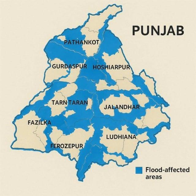
What This Map Shows\nThe map titled 'Flood-Affected Areas in Punjab, India' provides a visual representation of the regions impacted by flooding in this agriculturally significant state. Punjab, known for its fertile land and extensive canal systems, faces seasonal monsoons that can lead to severe flooding. This visualization highlights the areas most vulnerable to these natural disasters, revealing the extent of the damage and the communities affected.
Deep Dive into Flooding in Punjab\nFlooding is a crucial aspect of Punjab's climate and geography. The state is situated in the northwestern part of India and is interspersed with rivers and canals, primarily the Sutlej, Beas, and Ravi. These rivers are essential for irrigation and agriculture but can also be the source of devastating floods during the monsoon season, which typically spans from June to September.
Interestingly, Punjab's flat topography contributes to the severity of flooding. Unlike more mountainous regions where water can quickly drain away, the plains can hold water, leading to prolonged inundation. According to the Indian Meteorological Department, Punjab receives an average annual rainfall of about 600 mm to 800 mm, but during the monsoon months, this can spike significantly, overwhelming the region’s water management systems.
The floods not only disrupt daily life but also have a profound impact on the agricultural sector, which is the backbone of Punjab’s economy. Rice and wheat, the state's primary crops, are particularly susceptible to waterlogging, which can damage the crops before they are ready for harvest. In recent years, the state has faced challenges in managing floodwaters effectively, leading to increased calls for improved infrastructure and better flood management practices.
Interestingly, the floods in Punjab do not occur uniformly across the state. Some districts are more vulnerable based on their proximity to rivers, local topography, and the efficacy of drainage systems. For example, districts like Moga and Faridkot have historically faced more severe flooding due to their geographical configuration and the overflow from nearby rivers. In contrast, areas further away from the riverbanks may experience less impact.
Regional Analysis\nThe map categorizes flood-affected areas into various regions, allowing for a nuanced understanding of the situation. In the Majha region, which includes districts like Amritsar and Tarn Taran, flooding often results from the overflow of the Beas River. Here, the fertile plains provide rich agricultural land, but they are also prone to inundation, leading to crop losses and economic distress for farmers.
In the Malwa region, which encompasses districts like Bathinda and Mansa, the situation is compounded by a network of canals that can exacerbate flooding when heavy rains occur. These canals, while vital for irrigation, can back up and lead to significant waterlogging in surrounding areas. This has raised concerns about the need for improved water management and infrastructure to mitigate flooding risks.
The Doaba region, situated between the Beas and Sutlej rivers, often experiences less severe flooding compared to its neighbors. However, localized rainfall can still lead to flash floods, particularly in areas with inadequate drainage. The map effectively illustrates how different regions experience unique flooding dynamics that require tailored responses and interventions.
Significance and Impact\nUnderstanding the geography of flooding in Punjab is vital for multiple reasons. The implications extend beyond immediate economic losses; they touch on issues of food security, infrastructure resilience, and climate adaptation. As climate change continues to affect weather patterns, Punjab, like many other regions, must adapt to the increasing unpredictability of rainfall and flooding events.
Furthermore, the socio-economic impact of flooding is profound. Communities often face displacement, loss of livelihood, and damage to property. The government and local organizations must prioritize flood preparedness and response strategies to mitigate the adverse effects on vulnerable populations. Have you noticed that many areas with robust disaster management plans tend to recover faster from such events? This highlights the importance of proactive measures in building resilience.
In conclusion, the map of flood-affected areas in Punjab serves as a crucial tool for understanding the risks and realities of flooding in this region. It underscores the need for strategic planning and effective management to protect both the agricultural heartland of India and the lives of those who depend on it.
Visualization Details
- Published
- September 4, 2025
- Views
- 70
Comments
Loading comments...