Population Density Map of Tokyo, Los Angeles County, and California

David Chen
Data Visualization Specialist
David Chen is an expert in transforming complex geographic datasets into compelling visual narratives. He combines his background in computer science ...
Geographic Analysis
What This Map Shows
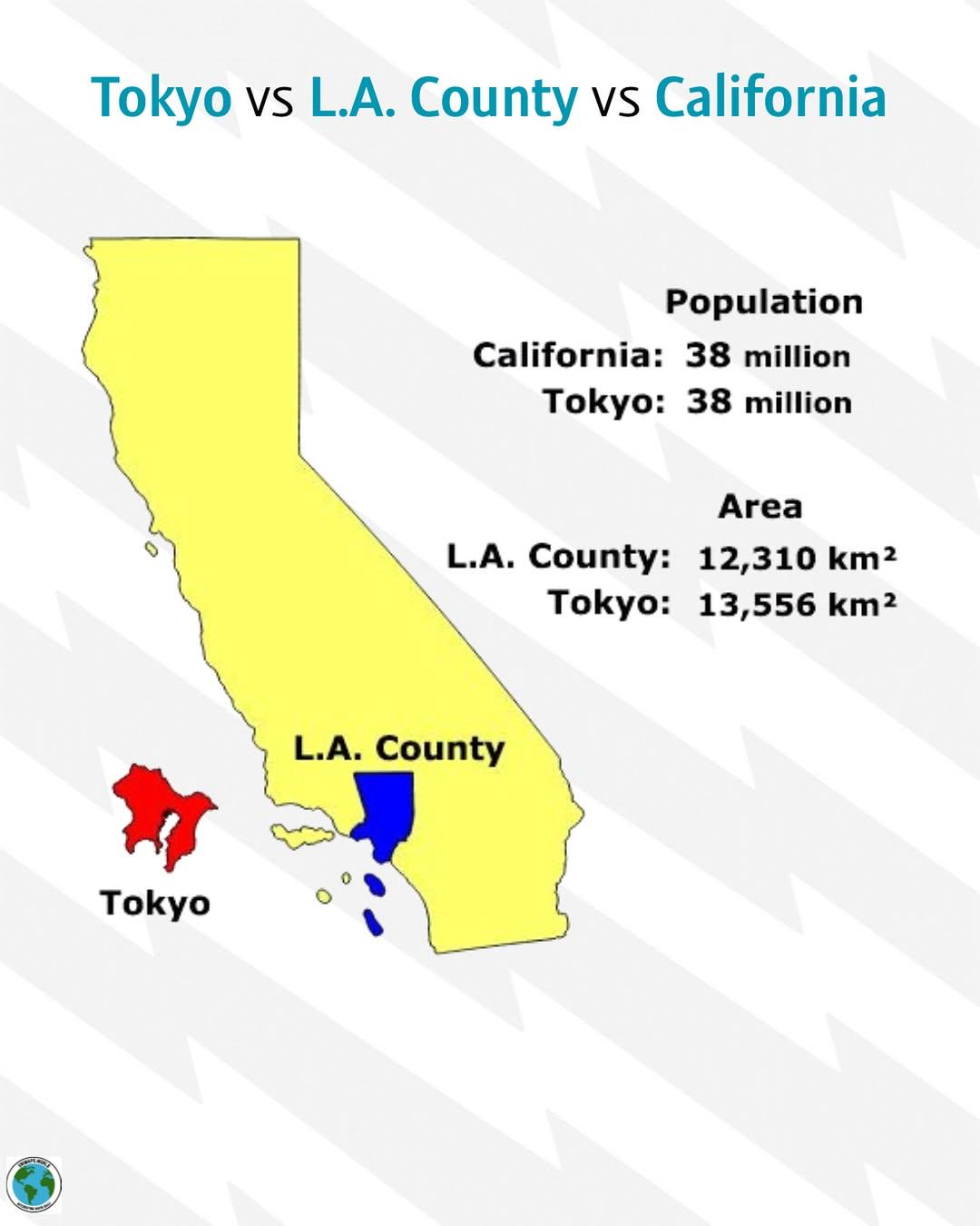
The visualization titled "Tokyo vs Los Angeles County vs California" presents a comparative analysis of population density across three distinct areas: Tokyo, Los Angeles County, and the broader state of California. By focusing on population density, we can gain insights into how these regions manage urbanization, resource allocation, and infrastructure development, making it a crucial metric for understanding their social dynamics.
Deep Dive into Population Density
Population density, defined as the number of people living per unit area, is a key indicator of how populated and urbanized a region is. In the case of Tokyo, this city boasts one of the highest population densities in the world, with estimates suggesting around 14,000 people per square kilometer in certain urban areas. This density is a result of Tokyo's extensive urban planning that maximizes space utilization, including high-rise buildings, efficient public transport systems, and a well-organized residential layout.
Interestingly, Tokyo's density also reflects its economic prowess; the city serves as a global financial center and offers a plethora of job opportunities, attracting a constant influx of residents from across Japan and beyond. However, this overwhelming density also leads to challenges, such as overcrowding, high living costs, and environmental concerns.
In contrast, Los Angeles County presents a markedly different scenario. While it is one of the most populous counties in the United States, with over 10 million residents, its population density is significantly lower, averaging around 3,200 people per square kilometer. This lower density can be attributed to the county's sprawling urban development, characterized by single-family homes, expansive suburbs, and a reliance on automobile transport. The cultural landscape of Los Angeles is diverse, with neighborhoods reflecting various ethnicities and lifestyles, but this spread-out nature leads to traffic congestion and challenges in public transport accessibility.
California as a whole, with its mix of urban and rural areas, has an average population density of about 97 people per square kilometer. This figure indicates the state's vast landscapes, including mountains, forests, and deserts, which contribute to lower population concentrations outside major urban centers like San Francisco, San Diego, and, of course, Los Angeles. The state's policies on land use and zoning significantly influence how population density is managed, often prioritizing sustainability and environmental conservation.
Regional Analysis
When analyzing the three regions displayed on the map, distinct patterns emerge. Tokyo's hyper-density presents both opportunities and challenges, with a highly developed public transport system that mitigates some issues related to overcrowding. However, as neighborhoods grow increasingly compact, concerns about green spaces and quality of life have become pronounced.
Los Angeles County, on the other hand, struggles with urban sprawl. The cultural diversity in neighborhoods like Koreatown or Little Tokyo showcases a vibrant community life, yet the need for effective public transportation is paramount to reduce reliance on cars. The contrast between urban and suburban living in LA is stark; while urban areas may experience higher density and associated challenges, suburban areas often face issues related to infrastructure and service provision.
California's regional variations in population density highlight an ongoing tension between development and environmental conservation. For instance, coastal areas face pressures from tourism and housing demands, while inland regions must balance agricultural needs with urban expansion. Each region’s approach to land use reveals much about their priorities and challenges.
Significance and Impact
Understanding population density is crucial for urban planning and policy-making. As cities like Tokyo and Los Angeles continue to grow, they face pressing issues related to housing, transportation, and public services. The implications of these trends extend beyond mere statistics; they affect quality of life, economic opportunities, and social equity.
Interestingly, trends in urbanization indicate that cities worldwide are becoming denser, which necessitates innovative solutions for sustainable living. As populations continue to grow, urban areas will need to rethink infrastructure, invest in public transport, and prioritize green spaces to ensure a high quality of life for future residents. Moreover, with climate change posing significant risks to urban environments, understanding and managing population density will be more critical than ever.
In conclusion, the population density map of Tokyo, Los Angeles County, and California serves as a vital tool for understanding the unique geographical and social dynamics at play in these regions. By examining these patterns, we can anticipate future trends and address the challenges that come with urban growth and development.
Visualization Details
- Published
- September 2, 2025
- Views
- 108
Comments
Loading comments...