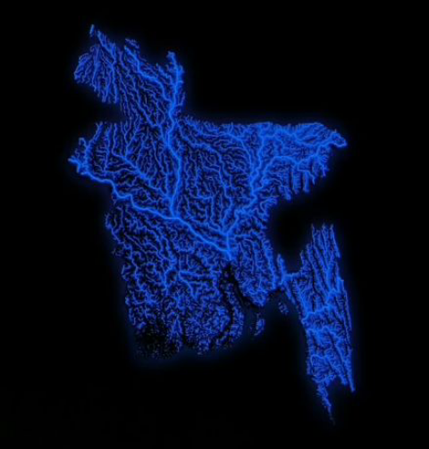
Map of All Bodies of Water in Bangladesh

David Chen
Data Visualization Specialist
David Chen is an expert in transforming complex geographic datasets into compelling visual narratives. He combines his background in computer science ...
Geographic Analysis
What This Map Shows
The map titled "Map of All Bodies of Water in Bangladesh" provides a comprehensive overview of the numerous rivers, lakes, ponds, and other water bodies that dot this lush and vibrant country. Situated in South Asia, Bangladesh is crisscrossed by an intricate web of waterways, making it one of the most water-rich nations in the world. This visualization highlights not just the major rivers but also the smaller tributaries and lakes, offering insight into how these bodies of water influence the landscape and the lives of the people living there.
Deep Dive into Bangladesh's Water Bodies
Bangladesh is renowned for its extensive river systems, primarily shaped by the confluence of the Ganges, Brahmaputra, and Meghna rivers. Together, they create what is known as the Sundarbans, the largest mangrove forest in the world and a UNESCO World Heritage site. Did you know that these rivers play a crucial role in the country's agriculture? They deposit fertile silt, making the land highly productive for farming. In fact, about 70% of Bangladesh's population depends on agriculture, with rice being the staple crop.
The Ganges River, known as the Padma in Bangladesh, flows through the western part of the country, while the Brahmaputra, known locally as the Jamuna, traverses the center. The Meghna River, which is a vital waterway for trade and transport, flows in the eastern region. These rivers are not just water sources; they are lifelines connecting communities and facilitating commerce. Interestingly, the monsoon season causes these rivers to swell and flood, which can be both a blessing and a curse. While these floods rejuvenate the soil, they also pose significant risks to housing and infrastructure.
Additionally, Bangladesh has numerous lakes and wetlands, such as the Haor wetlands in the northeastern region. These areas are crucial for biodiversity, supporting various species of fish and migratory birds. The lakes also provide important fishing grounds and recreational opportunities, contributing to local economies.
Regional Analysis
When examining the map, it's evident that the distribution of water bodies varies significantly across Bangladesh's different regions. For instance, the northern and eastern areas are characterized by extensive river networks and wetlands, which are essential for wildlife and agriculture. The Haor region, with its seasonal flooding, becomes a vibrant ecosystem during monsoon, attracting both local and migratory birds.
In contrast, the southwestern part of the country is home to the Sundarbans, where the interplay of freshwater and saltwater creates a unique habitat for species such as the Bengal tiger. This region's water bodies are vital for fishing and tourism, yet they are also facing threats from climate change, including rising sea levels and increased salinity.
Meanwhile, the capital city, Dhaka, is located near the confluence of the Buriganga River, which has suffered from pollution and encroachment. This starkly illustrates how urbanization and industrialization can drastically affect the quality and quantity of water bodies. The map allows us to explore these contrasts and understand how human activities impact the natural landscape.
Significance and Impact
The bodies of water in Bangladesh are not merely geographical features; they have profound implications for the environment, economy, and culture. With climate change posing severe challenges, including increased flooding and droughts, understanding these water bodies is crucial for planning and development. Sustainable management of water resources, including flood control and pollution reduction, is vital for the country's future.
Moreover, as urbanization continues to rise, ensuring the health of these water bodies will be essential for maintaining food security and protecting biodiversity. The map serves as a reminder of the interconnectedness of water systems and human activities. Preservation efforts and policies aimed at protecting these vital resources are more critical than ever, especially given the ongoing threats from industrial waste and climate change. Ever wondered how communities adapt to these challenges? The resilience of local populations often lies in their deep-rooted connections to these water bodies, showcasing a unique blend of tradition and innovation in coping strategies.
In conclusion, the "Map of All Bodies of Water in Bangladesh" is not just a static representation of geography; it reflects the dynamic relationship between the land and its people. By understanding this intricate network of waterways, we can appreciate the essential role they play in shaping the identity and livelihood of Bangladesh.
Visualization Details
- Published
- September 2, 2025
- Views
- 88
Comments
Loading comments...