Global Tides Map with Animated Visualization

Alex Cartwright
Senior Cartographer & GIS Specialist
Alex Cartwright is a renowned cartographer and geographic information systems specialist with over 15 years of experience in spatial analysis and data...
Geographic Analysis
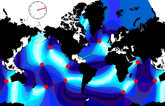
What This Map Shows
The "Animated Global Tides Map" provides a dynamic visualization of the world's tidal patterns, illustrating how ocean tides vary across different regions throughout the day. This map showcases the rise and fall of sea levels influenced by gravitational forces exerted by the moon and the sun. By animating these changes, viewers can grasp the temporal nature of tides and their spatial distribution, which is essential for understanding coastal environments and ocean navigation.
Deep Dive into Tides
Tides are one of the most observable natural phenomena on Earth, driven primarily by the gravitational pull of celestial bodies, particularly the moon. The science behind tides is fascinating and involves complex interactions between the Earth, moon, and sun. Have you ever wondered why some areas experience significant tidal ranges while others have minimal changes?
The basic mechanism behind tides is the gravitational force exerted by the moon, which causes water to bulge out in the direction of the moon. This results in high tides in those areas, while the regions at right angles to the moon experience low tides. This cyclical nature means that most coastal areas experience two high tides and two low tides in a 24-hour period.
Interestingly, the sun also plays a crucial role in this process. While its gravitational force is weaker than that of the moon, it still affects tides, particularly during spring and neap tides. Spring tides occur when the sun, moon, and Earth are aligned, leading to higher high tides and lower low tides. Conversely, neap tides happen when the sun and moon are at right angles, resulting in lower high tides and higher low tides.
The tidal range—the difference between high tide and low tide—varies significantly across the globe. For instance, the Bay of Fundy in Canada boasts the highest tidal range in the world, exceeding 16 meters (about 53 feet) in some areas. In contrast, regions like the Mediterranean Sea experience much smaller tidal ranges, often less than a meter. This variation can be attributed to factors such as coastline shape, ocean basin characteristics, and local geographical features.
Regional Analysis
When examining the animated global tides map, it's evident that tidal patterns are not uniform across the globe. For instance, the Pacific coast of North America experiences some of the most dramatic tidal fluctuations, while the eastern U.S. coast generally sees milder changes. In the UK, the tides are significantly influenced by the unique geography of the North Sea, leading to notable variations in tidal behavior along the coast.
In Asia, the tides along the coasts of countries like Japan exhibit distinct patterns due to the combination of the Kuroshio Current and the Pacific Ocean's larger tidal forces. Meanwhile, in Australia, the tides can be influenced by the Great Barrier Reef, creating unique tidal phenomena that impact marine life and coastal ecosystems.
What's fascinating is how these regional differences affect local economies and communities. Coastal towns often rely on predictable tidal patterns for fishing, tourism, and shipping activities. For example, cities like Venice are particularly vulnerable to tidal changes, which can lead to flooding, emphasizing the need for effective urban planning and management strategies.
Significance and Impact
Understanding tides is crucial for multiple reasons. For coastal communities, accurate tidal predictions are essential for safe navigation and fishing practices. Furthermore, with climate change posing a threat to sea levels, studying tides can provide insights into potential future scenarios for coastal erosion and habitat loss.
As sea levels rise, areas historically safe from flooding may become increasingly vulnerable. This shift could have profound implications for human settlements, local ecosystems, and even global trade routes. Thus, the animated global tides map not only serves as a tool for education but also highlights the importance of monitoring and adapting to our changing planet.
In conclusion, the study of tides is a gateway into understanding broader oceanographic phenomena and their impact on human life and the environment. As we continue to explore these dynamic patterns, we become better equipped to face the challenges posed by climate change and its effects on our world's coastlines.
Visualization Details
- Published
- September 2, 2025
- Views
- 88
Comments
Loading comments...