Partitions of Luxembourg Map

Alex Cartwright
Senior Cartographer & GIS Specialist
Alex Cartwright is a renowned cartographer and geographic information systems specialist with over 15 years of experience in spatial analysis and data...
Geographic Analysis
What This Map Shows
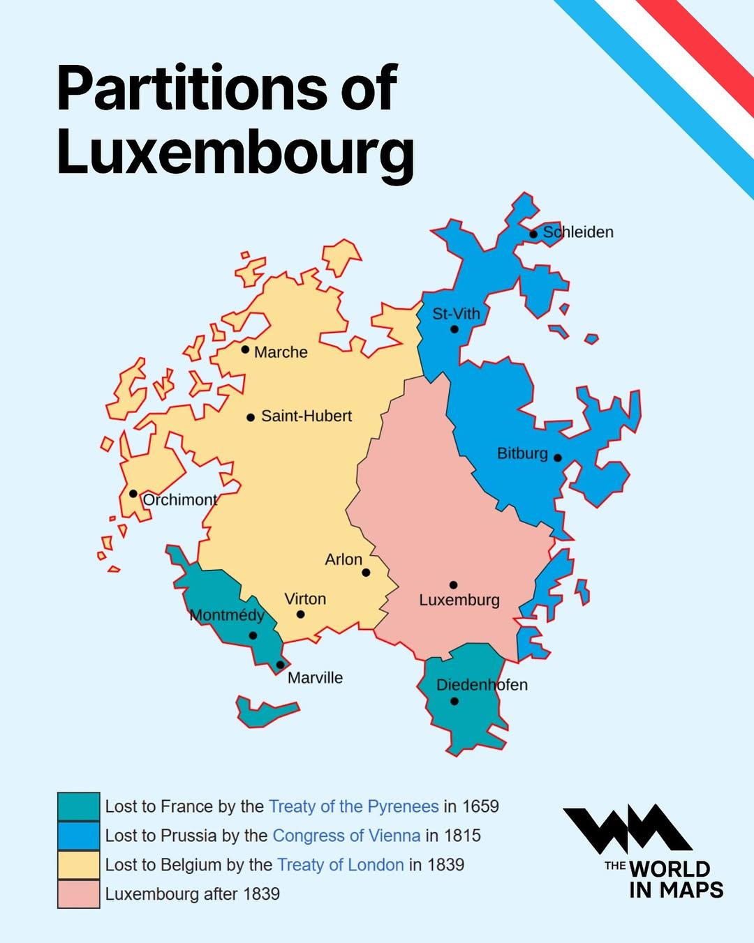
The "Partitions of Luxembourg Map" provides a clear depiction of the historical divisions and administrative changes that have shaped Luxembourg's political landscape over the centuries. It showcases the various partitions that have occurred due to territorial agreements, conflicts, and socio-political developments. By examining this map, we can gain insight into how Luxembourg evolved from a small county into a significant grand duchy in Europe.
Deep Dive into the Historical Context of Luxembourg
Luxembourg is a landlocked country in Western Europe, bordered by Belgium, France, and Germany. The nation has a rich history of partitions that reflect its strategic importance and the influence of larger neighboring powers. One of the key partitions occurred in the early 19th century, when the Congress of Vienna in 1815 established Luxembourg as a Grand Duchy. This was a pivotal moment, as it recognized Luxembourg's sovereignty while also placing it in a personal union with the Netherlands under King William I.
Interestingly, Luxembourg’s partition was not just a matter of political maneuvering; it also had profound implications for its cultural and linguistic identity. The map reveals how different regions within Luxembourg have been influenced by varying degrees of French, German, and Dutch cultural elements. For instance, the northern part, known as the Oesling, is characterized by its Ardennes mountains and retains a distinct influence from the Walloon region of Belgium. In contrast, the southern area, particularly around the city of Esch-sur-Alzette, showcases a more industrial and urbanized landscape, heavily influenced by its proximity to the industrial heartlands of Belgium and Germany.
Moreover, the partitions of Luxembourg were not solely about territorial divisions; they also involved complex demographic shifts. The map indicates areas of population density and urban development, which are crucial for understanding how the partitions impacted local communities. The capital, Luxembourg City, is a prime example of urban growth influenced by these historical changes. It has evolved into a financial and administrative center, attracting a diverse population and fostering economic development.
Regional Analysis
When analyzing the partitions of Luxembourg, it’s essential to consider the regional differences within the country. The map highlights several key areas: 1. **Luxembourg City**: As the capital, it serves as the political and economic hub. The city's growth has been remarkable, with a population that has surged due to its role as a financial center. 2. **The Oesling**: This mountainous region in the north is less populated and has a different economic base, focusing more on agriculture and tourism. The partitions here reflect a rural lifestyle that contrasts sharply with urban Luxembourg City. 3. **The Minett Region**: Known for its rich mining history, this area has undergone significant economic transitions. The map shows how historical partitions have led to industrial growth, which has since evolved into a service-based economy. 4. **The Müllerthal Region**: Often referred to as Luxembourg’s Little Switzerland, this picturesque area is known for its stunning landscapes and hiking trails. The partitions here allowed for a unique blend of cultural influences, making it a popular tourist destination.
By comparing these regions, we can observe how historical events have shaped not just the political boundaries but also the socio-economic landscapes of each area. The differences in population density, economic activities, and cultural influences are stark, underscoring the complexity of Luxembourg's development.
Significance and Impact
Understanding the partitions of Luxembourg is crucial for several reasons. Firstly, it provides insight into the geopolitical strategies of European powers, especially during times of conflict and change. Luxembourg's strategic location has made it a focal point for various military and diplomatic maneuvers throughout history.
Moreover, the implications of these partitions extend into contemporary issues such as national identity and cultural heritage. Have you noticed how Luxembourg's multicultural society reflects its historical partitions? Today, the country is home to a diverse population, with significant communities of expatriates, which has enriched its cultural fabric.
Looking ahead, the significance of Luxembourg's partitions may continue to evolve, especially in the context of European integration and global geopolitics. As the EU navigates challenges like Brexit and economic disparities, Luxembourg’s position as a stable and prosperous member state will likely influence discussions on regional cooperation and development.
In conclusion, the "Partitions of Luxembourg Map" not only illustrates historical divisions but also serves as a window into the rich tapestry of Luxembourg’s history. By understanding these partitions, we gain a deeper appreciation of the country’s unique identity and its role in the broader European landscape.
Visualization Details
- Published
- September 1, 2025
- Views
- 100
Comments
Loading comments...