Polish–Lithuanian Commonwealth Maximum Extent Map

Alex Cartwright
Senior Cartographer & GIS Specialist
Alex Cartwright is a renowned cartographer and geographic information systems specialist with over 15 years of experience in spatial analysis and data...
Geographic Analysis
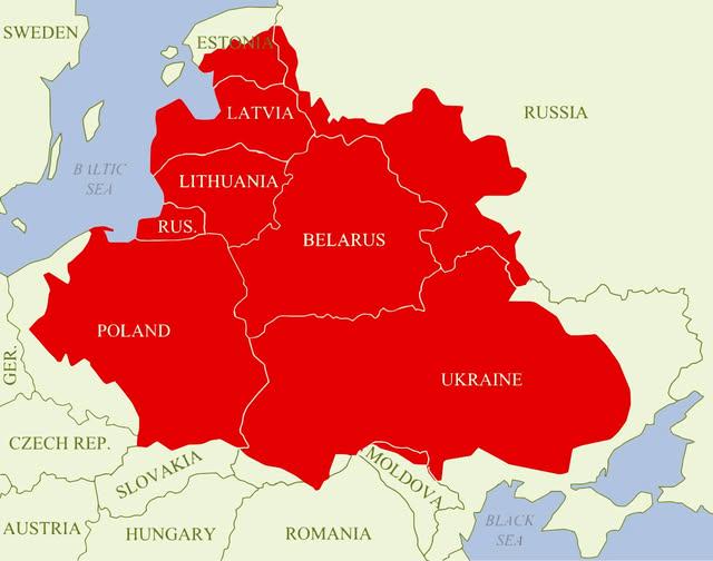
What This Map Shows
The visualization titled "Polish–Lithuanian Commonwealth at its maximum extent over modern borders" depicts the historical reach of the Polish–Lithuanian Commonwealth, a significant political entity that existed from 1569 to 1795. This map overlays the boundaries of the Commonwealth onto contemporary borders, providing a visual representation of its vast territory, which included parts of modern-day Poland, Lithuania, Latvia, Belarus, Ukraine, and even parts of Russia and Moldova. By examining this map, we gain insights into the geopolitical dynamics of Eastern Europe during the late medieval and early modern periods.
Deep Dive into the Polish–Lithuanian Commonwealth
The Polish–Lithuanian Commonwealth was a unique political union formed between the Kingdom of Poland and the Grand Duchy of Lithuania. At its zenith, around the late 16th century, it was one of the largest and most populous countries in Europe. The Commonwealth was notable for its democratic system of governance, which featured a unique elective monarchy, and a nobility that played a crucial role in state affairs.
Interestingly, the Commonwealth was characterized by a diverse population comprising various ethnic groups, including Poles, Lithuanians, Ukrainians, Belarusians, and Jews. This cultural mosaic contributed to a rich tapestry of social and political life, evident in the vibrant cities and towns that dotted the landscape.
The Commonwealth's economy thrived on agriculture, trade, and craft production. The fertile lands, particularly in the Mazovian plains and the region of Podolia, supported a robust agricultural system, while cities like Gdańsk became bustling trade centers crucial to the Baltic trade routes. Moreover, the Commonwealth was known for its religious tolerance, particularly during the early years, allowing diverse faiths to coexist, which was relatively rare for that era.
However, the Commonwealth also faced significant challenges. Its vast territory made it difficult to govern effectively, leading to administrative inefficiencies and internal discord. The famed 'Golden Liberty'—the privileges enjoyed by the nobility—often hampered the central authority, resulting in a weakened state that struggled to defend its borders against external threats. The Commonwealth's eventual partition in the late 18th century by its neighboring powers—Russia, Prussia, and Austria—highlighted these vulnerabilities, leading to its dissolution in 1795.
Regional Analysis
Examining the regions included in the map sheds light on the historical context of the Commonwealth. For instance, the territory that is now Poland was central to the Commonwealth's governance, with cities like Warsaw and Kraków serving as political and cultural hubs. Warsaw, in particular, became the capital in the late 16th century, symbolizing the union's aspirations and unity.
Moving eastward, modern-day Lithuania and Belarus were also critical to the Commonwealth's identity. Vilnius, the capital of Lithuania, was a significant center for trade and culture, while Minsk emerged as a key urban center in Belarus. The eastern fringes, which encompass parts of Ukraine, were agricultural heartlands that provided the necessary resources for the Commonwealth's economy. Here, the Cossack uprisings in the 17th century would later shape the region's future trajectory and its relationship with the Commonwealth.
Interestingly, the western regions of the Commonwealth, which now include parts of modern-day Latvia and Estonia, were more influenced by trade with the Hanseatic League. This area had a distinct cultural influence, which can still be observed today in the architecture and urban planning of cities like Riga.
Significance and Impact
Understanding the historical scope of the Polish–Lithuanian Commonwealth is essential for grasping the complex geopolitical landscape of Eastern Europe today. The legacy of the Commonwealth can be seen in the cultural and political divisions that exist in the region. The historical narratives, shaped by centuries of conflict and cooperation, continue to influence national identities and international relations.
Moreover, the Commonwealth's model of governance, particularly its early democratic elements, provides an interesting case study for understanding the evolution of political systems in Europe. As nations in the region navigate the challenges of modernity, including issues of nationalism and regional cooperation, the historical context of the Commonwealth remains relevant.
In conclusion, the Polish–Lithuanian Commonwealth serves as a vital reference point for historical geography, illustrating the interplay of culture, politics, and economy in shaping a region that remains dynamic and diverse. As we reflect on the lessons learned from its history, we can better appreciate the complexities of contemporary Eastern Europe and the enduring impact of its past.
Visualization Details
- Published
- August 31, 2025
- Views
- 78
Comments
Loading comments...