Public Transit Usage by Metro Area Map

David Chen
Data Visualization Specialist
David Chen is an expert in transforming complex geographic datasets into compelling visual narratives. He combines his background in computer science ...
Geographic Analysis
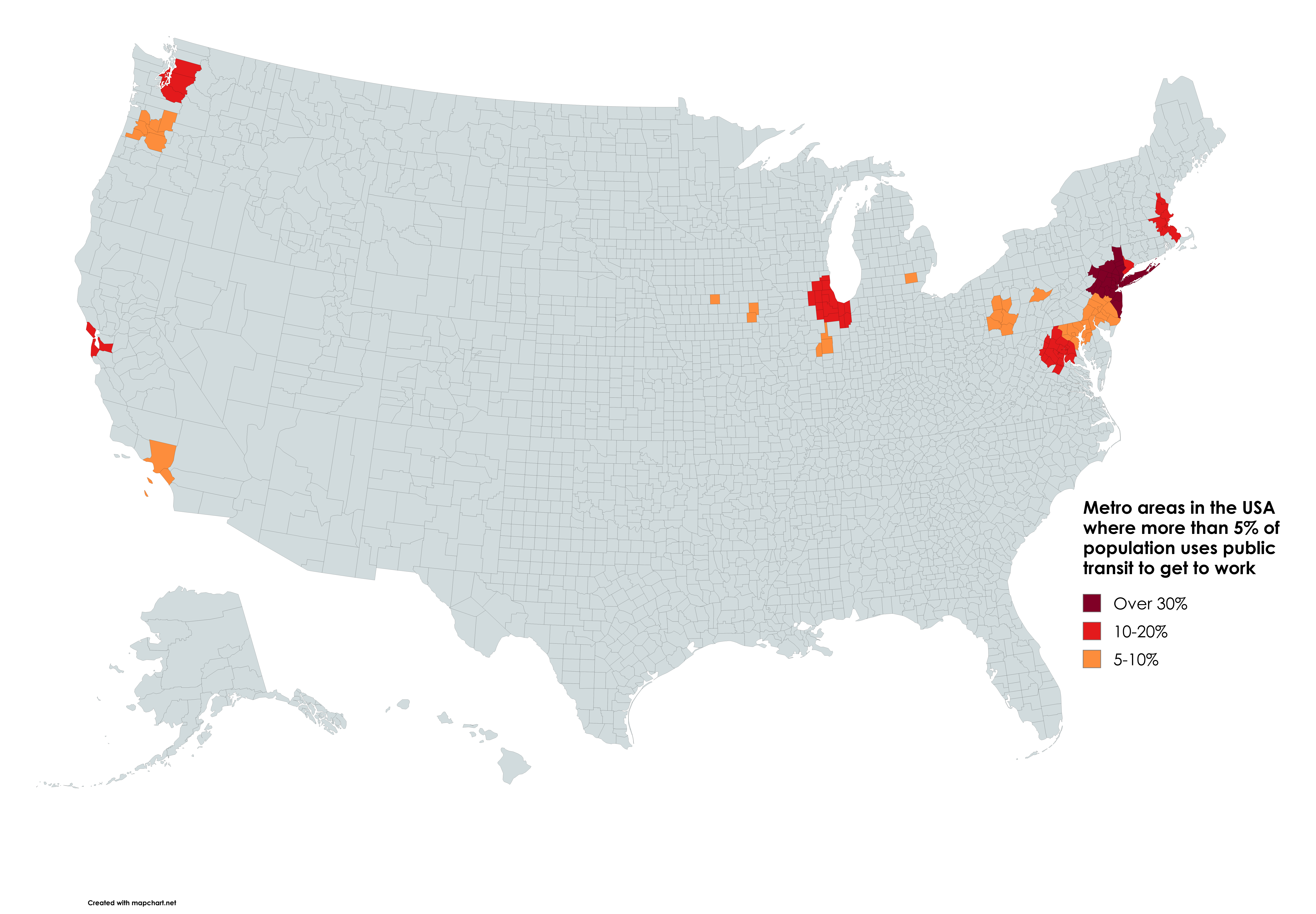
What This Map Shows\nThis map visualizes the metro areas in the United States where more than 5% of the population utilizes public transit as their primary mode of transportation to work. This statistic is not just a number; it reflects broader trends in urban development, infrastructure investment, and commuting behavior. Public transit systems, which include buses, subways, and light rail, play a crucial role in shaping how people live and move within urban environments.
Deep Dive into Public Transit Usage\nPublic transit is essential for numerous reasons, including reducing traffic congestion, lowering greenhouse gas emissions, and providing accessible transportation options for those without cars. Interestingly, cities that have invested heavily in public transit infrastructure often see a higher percentage of their residents relying on these systems for daily commutes.
According to the latest data from the U.S. Census Bureau, cities like New York, San Francisco, and Washington D.C. showcase some of the highest public transit usage rates, often exceeding 30%. The reasons for this are multifaceted: dense populations, extensive transit networks, and cultural attitudes toward public transportation all contribute to these figures. Moreover, cities with a robust public transit system tend to attract more residents and businesses, creating a cycle of economic growth and urban development.
In contrast, cities with lower usage rates, such as those in more suburban or rural settings, often lack the necessary infrastructure or have a cultural bias toward car ownership. Interestingly, the availability of public transit can significantly influence housing markets; areas near transit lines often see higher property values and increased demand. This dynamic illustrates the connection between transportation options and urban planning, highlighting that efficient public transit can lead to more sustainable, livable cities.
Public transit also impacts social equity. In areas where public transit is accessible, individuals from various socioeconomic backgrounds can commute to jobs, access education, and access healthcare facilities. However, in regions where public transit is limited, those without cars may face significant barriers, exacerbating inequality.
Regional Analysis\nLet’s take a closer look at some of the metro areas on the map. In New York City, for instance, over 60% of commuters use public transit, a testament to the extensive subway and bus network that connects the five boroughs. This high level of usage drastically reduces the number of cars on the road, contributing to lower traffic congestion and pollution levels.
In contrast, cities like Los Angeles, despite having a sprawling population, have only about 9% of residents using public transit. The city’s car-centric culture and extensive highway system have led to a reliance on personal vehicles. However, recent efforts to expand the Metro system might change this trend in the coming years, as city planners recognize the need for sustainable infrastructure solutions.
Another region worth examining is the San Francisco Bay Area, where around 20% of the population uses public transit. Here, the Bay Area Rapid Transit (BART) system, along with local buses and ferries, provides a comprehensive network that facilitates commuting across the region. This integrated system not only eases traffic flow but also promotes environmental sustainability, a crucial factor as the area grapples with air quality issues and climate change.
Significance and Impact\nUnderstanding public transit usage is paramount, especially as cities continue to grapple with rising populations and environmental concerns. The shift towards public transportation can lead to numerous benefits, from reduced traffic congestion to lower carbon footprints. As cities evolve, the demand for efficient public transit systems will only grow, making it essential for urban planners to prioritize these networks in future developments.
Furthermore, with the rise of remote work and changing commuting patterns post-pandemic, public transit systems face unique challenges and opportunities. As people reconsider their commuting habits, cities might need to adapt their transit offerings to meet new demands, ensuring that these systems remain viable and attractive. Have you noticed how some cities are reimagining their transit systems to be more flexible and responsive to the needs of their residents?
As we look ahead, the role of public transit will be crucial in shaping not just the logistical landscape of cities, but also their economic and social fabric. Investing in public transit infrastructure is no longer just about transportation; it’s about building resilient, equitable communities for future generations.
Visualization Details
- Published
- August 31, 2025
- Views
- 68
Comments
Loading comments...