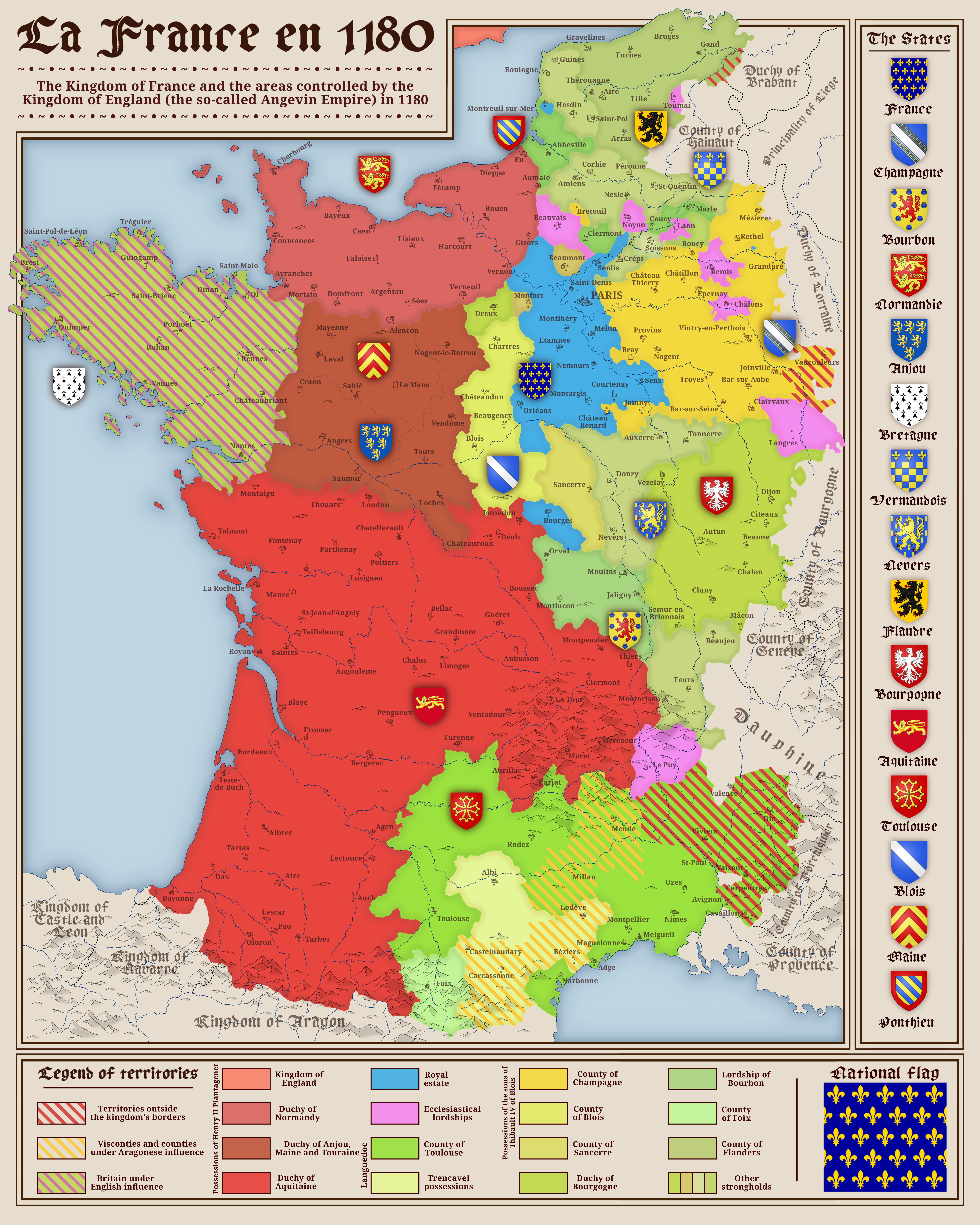
Political Map of France in 1180

David Chen
Data Visualization Specialist
David Chen is an expert in transforming complex geographic datasets into compelling visual narratives. He combines his background in computer science ...
Geographic Analysis
What This Map Shows
The map titled "France in 1180" provides a detailed view of the political landscape of France during the late 12th century. This was a pivotal time in French history, marked by significant territorial divisions and the influence of feudalism. The visualization illustrates the various regions and principalities that existed at that time, highlighting the feudal lords' territories, major cities, and the boundaries that defined power and governance in medieval France.
Deep Dive into Feudal France
Feudalism was the backbone of society in 1180, dictating not only political structures but also social hierarchies and economic relationships. The map serves as a reminder of a time when land ownership was synonymous with power. The king, at the helm, was Philip II, also known as Philip Augustus. His reign marked the beginning of France's transformation from a collection of feudal territories into a more centralized state.
Interestingly, the map reveals the fragmented nature of territories. France was not yet the unified nation we know today. Instead, it was a patchwork of duchies, counties, and principalities, each ruled by local lords who owed allegiance to the king but often acted independently. The most notable regions included the Duchy of Normandy, the County of Anjou, and the County of Toulouse. Each of these areas had its own unique political dynamics and social structures, influenced by local customs and the personal ambitions of their rulers.
What's fascinating is the role of powerful families during this period. For instance, the Plantagenets, who ruled over England and held territories in France, created a significant challenge to the French monarchy. Their influence is evident in the map, as the territories they controlled often overlapped with those of Philip II, leading to ongoing conflicts that would shape future generations.
Moreover, the map also highlights the importance of urban centers during this time. Cities like Paris, which was becoming a political and cultural hub, played a crucial role in connecting various regions and facilitating trade. The development of towns was vital for economic growth, providing a different dimension to feudal life, where serfs and peasants worked the land but increasingly sought opportunities in burgeoning urban environments.
Regional Analysis
Examining the regions depicted in the map reveals stark contrasts in governance and social structure. The northern regions, particularly around Paris and Normandy, were more developed, featuring fortified towns and a more stable economic environment. In contrast, the southern regions like the County of Toulouse were less centralized, with greater influence from local lords and a more diverse set of cultures due to proximity to the Iberian Peninsula.
For example, the County of Flanders, located to the northeast, was an economic powerhouse, known for its cloth trade and vibrant market towns. This prosperity attracted the attention of both the French crown and neighboring powers, leading to a tug-of-war for control over this lucrative region. In contrast, areas like Aquitaine faced challenges due to their geographical distance from the king's influence, often leading to a more autonomous governance by local lords.
This regional disparity illustrates how geography was not just a backdrop but a crucial factor influencing power dynamics. The wealth of resources in one area could lead to tensions with neighbors, as seen in the conflicts between the French and English during this period.
Significance and Impact
Understanding the political landscape of France in 1180 is crucial for grasping the historical context of subsequent events, including the rise of the Capetian monarchy and the eventual unification of France. This period set the stage for the Hundred Years' War and the larger struggles between England and France that would dominate the next several centuries.
Furthermore, the feudal system's legacy can still be seen in modern France's regional divisions and cultural differences. Have you noticed that the echoes of medieval governance persist in contemporary administrative regions? The historical alliances and rivalries established during this time have influenced modern identity and territorial disputes, making this map not just a snapshot of the past but a foundational piece of French history.
As we explore the significance of feudalism and its impact on the socio-political landscape, we recognize the importance of understanding our past to appreciate how it shapes the present. The political map of France in 1180 is more than an artifact; it is a testament to the complexities of human governance and the ongoing evolution of national identity.
Visualization Details
- Published
- August 30, 2025
- Views
- 66
Comments
Loading comments...