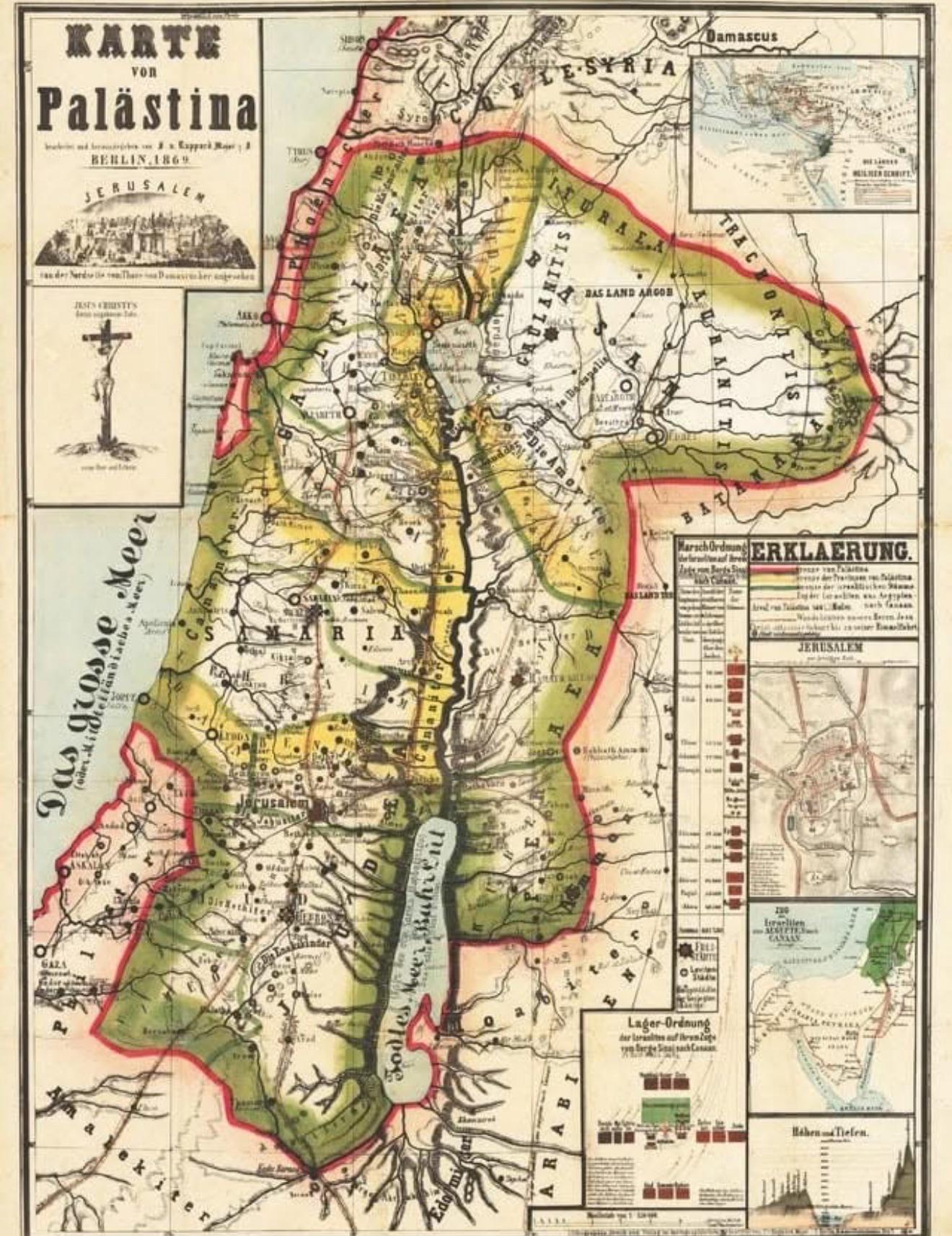
German Map of Palestine in Berlin 1869

Alex Cartwright
Senior Cartographer & GIS Specialist
Alex Cartwright is a renowned cartographer and geographic information systems specialist with over 15 years of experience in spatial analysis and data...
Geographic Analysis
What This Map Shows
The "German Map of Palestine in Berlin in 1869" offers a detailed glimpse into the geographical and political landscape of the region during a pivotal time in history. The map showcases the territorial boundaries, major cities, and significant landmarks of Palestine as understood by German cartographers in the late 19th century. It reflects not only the physical geography but also the sociopolitical dynamics of the time, providing a unique snapshot of a region that has seen extensive change over the following decades.
Deep Dive into Palestine's Geography in 1869
Palestine, during the late 19th century, was characterized by a diverse geography that included rugged terrains, fertile valleys, and a Mediterranean coastline. The map serves as a historical document, revealing how cartographers viewed the region amidst the Ottoman Empire's influence, which ruled over Palestine at the time.
One of the notable geographical features depicted on the map is the Jordan River, which has historically been a vital water source and a cultural symbol for various communities. The river flows from the north, through the Sea of Galilee, and down to the Dead Sea, which is the lowest point on earth. The river's banks were dotted with settlements that played crucial roles in trade and agriculture, emphasizing the importance of water accessibility in the region.
The map also highlights major urban centers such as Jerusalem, Jaffa, and Hebron. Jerusalem, a city of immense religious significance for Judaism, Christianity, and Islam, is depicted with distinct landmarks, including the Old City and its surrounding walls. Interestingly, during this time, Jerusalem was experiencing an influx of European influences, as various Christian communities established themselves in the city, which would later lead to significant demographic changes.
Furthermore, the map illustrates the agricultural landscape of Palestine. The region was known for its olive groves, vineyards, and grain production, which formed the backbone of the local economy. The distribution of these agricultural activities can be observed, revealing how the land was utilized and how rural communities were organized.
However, the map also hints at the underlying tensions in the region. In 1869, Palestine was at a crossroads, with increasing European interest leading to changing dynamics among the local populations. The Zionist movement was just beginning to take shape, setting the stage for future conflicts and demographic shifts.
Regional Analysis
When examining the map more closely, we can analyze the distinct regions of Palestine and their characteristics. For instance, the coastal areas, such as Jaffa, were bustling trade ports that connected Palestine to the wider Mediterranean world. Jaffa, in particular, was known for its citrus exports, which were critical to the economy.
In contrast, the interior regions, such as the hills of Judea and Samaria, were more rural and agricultural. Here, communities relied heavily on farming, with olive oil and grains being staple products. Comparing these areas shows a clear divide between urban and rural lifestyles, with cities like Jerusalem serving as cultural and administrative hubs while rural areas maintained traditional agricultural practices.
Interestingly, the map also reveals demographic patterns. The Jewish population began to increase gradually due to immigration influenced by the Zionist movement, particularly from Eastern Europe. This shift would lay the groundwork for future conflicts as diverse communities began to vie for land and resources.
Significance and Impact
The significance of this 1869 map extends beyond mere historical interest. It serves as a reminder of how geography shapes human interactions, conflicts, and identities. The geopolitical boundaries illustrated on this map would evolve, especially with the advent of modern nationalism and the eventual establishment of the State of Israel in 1948.
Today, the historical context provided by such maps is crucial for understanding ongoing conflicts in the region. The demographics, land use, and urban development patterns have lasting effects on the socio-political landscape. Moreover, this map invites us to consider the environmental challenges faced by the region, including water scarcity and land degradation, issues which are increasingly pressing today.
As we look to the future, it’s essential to reflect on the lessons of the past. Understanding the geographical and cultural foundations of Palestine can inform current discussions about peace, coexistence, and sustainable development in a region marked by complexity and diversity. Ever wondered how such historical maps influence contemporary discussions? They are not just relics but tools that can help us navigate the pathways to a more informed and empathetic future.
Visualization Details
- Published
- August 29, 2025
- Views
- 74
Comments
Loading comments...