Topographic Map of Africa

Marcus Rodriguez
Historical Geography Expert
Marcus Rodriguez specializes in historical cartography and geographic data analysis. With a background in both history and geography, he brings unique...
Geographic Analysis
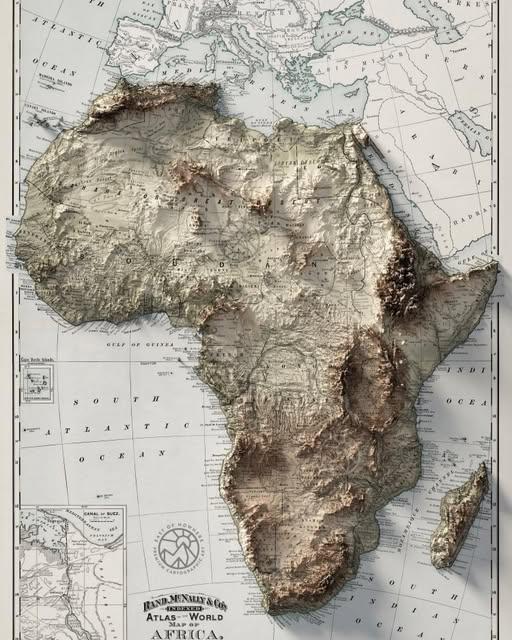
What This Map Shows
The topographic map of Africa is a fascinating representation of the continent's varied landscapes, showcasing its mountains, plateaus, plains, and valleys. It details not only the elevation changes across the continent but also highlights significant geographical features such as rivers, lakes, and deserts. One can easily visualize the vast differences in terrain from the towering peaks of the Atlas Mountains in the northwest to the sprawling Great Rift Valley in the east, and the extensive lowlands that characterize much of Western Africa. The colors and contour lines on the map help to portray how elevation changes across different regions, providing insights into the underlying geological processes that shape Africa's diverse topography.
Deep Dive into Africa's Topography
Africa’s topography is incredibly diverse, making it one of the most geologically rich continents in the world. It is home to the world’s second-highest mountain, Mount Kilimanjaro, which stands at 5,895 meters (19,341 feet) in Tanzania. This iconic peak is not just a natural landmark; it serves as a climatic indicator, showcasing how elevation affects weather patterns and ecosystems. Interestingly, the mountain’s glaciers are melting at an alarming rate due to climate change, highlighting the intricate connection between topography and environmental shifts.
The continent's topography is primarily divided into three main regions: the highlands, the plateaus, and the lowlands. The East African Highlands, for instance, are characterized by rugged terrain and volcanic activity, shaped by tectonic forces. This region includes significant features like the Ethiopian Highlands and the Great Rift Valley, which are crucial for biodiversity and agriculture.
Have you noticed how the Great Rift Valley not only creates stunning landscapes but also serves as a catalyst for the region's unique ecosystems? The rift is home to many endemic species that rely on specific geographical conditions for survival. Furthermore, the rift's lakes, such as Lake Victoria and Lake Tanganyika, are vital freshwater resources that support millions of people.
In contrast, the Sahara Desert, which dominates North Africa, presents a stark contrast to the lush highlands of the south. Spanning over 9 million square kilometers, the Sahara is not only the largest hot desert in the world but also a region that has significant implications for climate and human settlement. The harsh conditions limit agricultural activities, leading to a concentration of populations in oases and along the Mediterranean coast.
Interestingly, Africa's topography also plays a crucial role in its hydrology. Major river systems, such as the Nile, Congo, and Zambezi Rivers, are influenced by the continent's elevation. The Nile, for instance, flows northward from the highlands of East Africa, illustrating how mountains can be the source of major water bodies. The Congo River, on the other hand, is one of the world's largest and most powerful rivers, carving its way through the dense rainforests of Central Africa, showcasing how topography and climate interact to create rich ecosystems.
Regional Analysis
When breaking down Africa’s topography by region, distinct patterns emerge. The northern region, dominated by the Sahara, has a relatively flat terrain, with scattered mountains like the Atlas Range. This flatness affects climate, leading to arid conditions and limited agricultural opportunities. In stark contrast, West Africa features a mix of lowlands and highlands, with the Fouta Djallon mountain range playing a crucial role in the hydrology of the region. It acts as a watershed for several rivers, including the Gambia, Senegal, and Niger, which are vital for the livelihoods of millions.
Moving to Central Africa, the Congo Basin is marked by low-lying terrain and thick rainforests, which are critical for biodiversity. The region's topography allows for diverse habitats, making it one of the most important ecological zones in the world. Meanwhile, southern Africa is characterized by plateaus and mountain ranges, such as the Drakensberg Mountains in South Africa, affecting both weather patterns and human settlement.
Significance and Impact
Understanding Africa's topography is vital, not just for geographical knowledge but for its implications on human life, agriculture, and climate. The continent's varied landscapes influence everything from weather patterns and rainfall distribution to biodiversity and natural resource management. For instance, the elevation and terrain impact agricultural practices, as certain crops thrive in specific conditions.
Moreover, as climate change continues to pose challenges, the topography of Africa will be an important factor in how communities adapt. Regions like the Sahel, which borders the Sahara, face increasing desertification, while the highlands may experience altered rainfall patterns. This interplay between geography and climate is crucial for policymakers and environmentalists alike.
As Africa's population continues to grow, urbanization will increasingly impact the continent's landscapes. Understanding the topography will be essential for sustainable development, disaster management, and conservation efforts. Looking ahead, investing in knowledge about Africa’s topography can lead to better resource management, resilience against climate change, and a sustainable future for its diverse populations.
Visualization Details
- Published
- August 28, 2025
- Views
- 84
Comments
Loading comments...