1789 Map of Northern England Map

Marcus Rodriguez
Historical Geography Expert
Marcus Rodriguez specializes in historical cartography and geographic data analysis. With a background in both history and geography, he brings unique...
Geographic Analysis
What This Map Shows
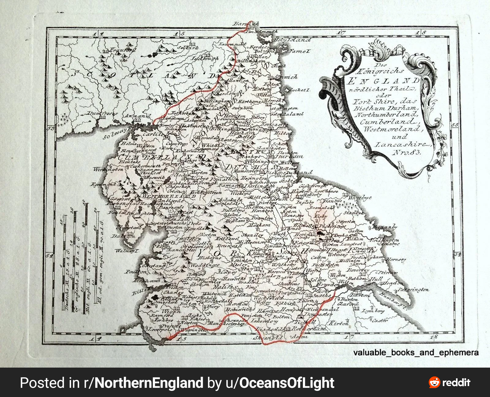
The 1789 map of Northern England created by Austrian cartographer Franz Joseph Von Reily is a remarkable historical artifact that provides insights into the geographical landscape of the region during the late 18th century. This map not only showcases the physical geography, including mountains, rivers, and towns, but also reveals the socio-political context of Northern England at that time. It serves as a snapshot of an era when cartography was evolving, and the importance of accurate mapping was becoming increasingly recognized.
As we delve deeper into the specifics of the map, we can observe how it illustrates not just the topographical features but also the intricate web of human settlements and transportation routes. The representation of various towns and cities highlights the burgeoning trade and economic activities that marked this period of Northern England's history.
Deep Dive into Northern England’s Geography
Northern England is characterized by its diverse geography, which includes rugged hills, rich valleys, and significant waterways. One of the most prominent features illustrated on the map is the Pennine mountain range, often referred to as the "backbone of England." This range has historically influenced settlement patterns, as communities tended to develop in the valleys and along the riverbanks, making it easier for trade and agriculture.
Rivers such as the Tyne, Wear, and Tees are crucial to understanding the region’s geography. These waterways not only provided a means of transport for goods but also facilitated the establishment of industries, particularly during the Industrial Revolution that followed shortly after this map was created. The Tyne, for instance, became a major industrial hub, supporting shipbuilding and coal exportation, which were vital to the economy.
Interestingly, the map reflects the network of roads that existed at the time, showcasing how human activity shaped the landscape. The reliance on rivers and roads for trade and transportation set the stage for urban development in the subsequent decades. In fact, cities like Newcastle-upon-Tyne, which is prominently featured, grew significantly due to their strategic locations along these transport routes.
Regional Analysis
When we break down the map regionally, several key areas stand out. The northeast coastline, featuring towns like Whitby and Scarborough, was known for its fishing industry and trade with the continent. The map illustrates how these coastal towns were interconnected with inland settlements, allowing for a vibrant exchange of goods.
Moving inland, the rich agricultural lands around York and the Vale of York are evident. This region was historically significant for its fertile soil, which supported farming and livestock rearing. Interestingly, York itself was a major center for trade and governance, reflecting its historical importance as a Roman city.
In stark contrast, the western part of Northern England, characterized by the Lake District, presents a different picture. This area, while less densely populated, is renowned for its natural beauty and was integral to the development of tourism in later years. The map captures the essence of these varied landscapes and the unique characteristics that distinguish each region.
Significance and Impact
Understanding the geography depicted in the 1789 map of Northern England is crucial for grasping how this region has evolved over time. The historical context provided by the map allows us to see the foundations of modern towns and cities that were built upon these early trade routes and geographical advantages.
Moreover, this map serves as a reminder of the importance of cartography in facilitating economic development. The accuracy of the map reflects the growing interest in geography and the need for reliable navigation, which played a significant role in expanding trade networks.
Today, as we reflect on the historical geography of Northern England, we can trace the influence of these early maps on contemporary urban planning and development. With ongoing discussions about regional sustainability and environmental conservation, understanding the historical context becomes even more relevant. Have you noticed how modern maps still echo the patterns established centuries ago? The legacy of cartographers like Von Reily lives on, continuing to shape our understanding of the world around us.
Visualization Details
- Published
- August 27, 2025
- Views
- 86
Comments
Loading comments...