Largest Countries in Europe by Land Area Map

David Chen
Data Visualization Specialist
David Chen is an expert in transforming complex geographic datasets into compelling visual narratives. He combines his background in computer science ...
Geographic Analysis
What This Map Shows
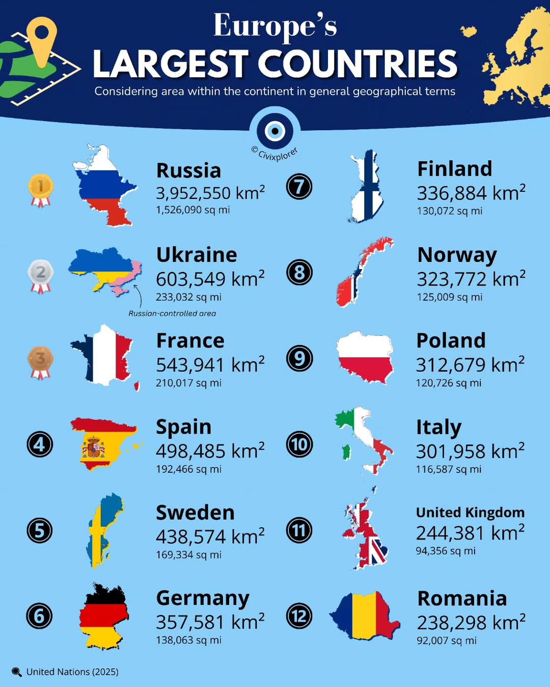
This map presents a clear visualization of the largest countries in Europe by land area, showcasing the vast differences in size among the continent's nations. It serves as a useful tool for understanding the geographic landscape of Europe. For instance, you can see how Russia, which extends into both Europe and Asia, dominates the map in terms of land area, dwarfing other countries. The map also highlights countries like Ukraine, France, and Spain, allowing for a quick comparison of their relative sizes.
Deep Dive into the Largest Countries in Europe
When it comes to land area, Europe is home to some of the largest countries in the world. The largest country, Russia, spans 17,098,242 square kilometers, with a significant portion of its landmass located in Europe. However, it's essential to note that only about 23% of Russia's total area is situated within the European continent. The sheer scale of Russia's territory is impressive, encompassing diverse geographical features ranging from vast plains to rugged mountains and extensive forests.
Next on the list is Ukraine, covering approximately 603,500 square kilometers. Interestingly, Ukraine's size places it among the largest countries in Europe, making it a significant player in the region. Its landscape is characterized by fertile plains, rolling hills, and the Carpathian Mountains, which add to its geographical diversity.
France follows closely, with a land area of around 551,695 square kilometers. What's fascinating is that France's size includes not only its mainland but also several overseas territories, which contribute to its overall area. The French landscape is incredibly varied, featuring coastal regions, mountains like the Alps, and extensive river systems.
Spain, covering 505,990 square kilometers, is another major country in Europe by land area. Spain’s geography includes the Iberian Peninsula, mountain ranges like the Pyrenees, and a variety of climate zones, which range from Mediterranean to arid.
Other notable mentions include Sweden, Norway, and Finland, each with land areas exceeding 300,000 square kilometers. Sweden, for instance, is known for its stunning archipelagos and extensive forests, while Norway's dramatic fjords and rugged terrain define its geography. Finland, on the other hand, is famous for its thousands of lakes and a landscape that seems untouched by time.
Regional Analysis
Breaking down the map by region reveals interesting insights into the geographical distribution of land area in Europe. Eastern Europe features some of the continent's largest countries, such as Russia and Ukraine, which are characterized by vast expanses of land that are often sparsely populated. This vastness contributes to a range of environmental and economic challenges, including resource management and agricultural production.
In contrast, Western Europe, which includes countries like France and Spain, exhibits a different pattern. These nations are not only sizeable but also densely populated, leading to a greater emphasis on urban development and infrastructure. For example, France's significant land area is complemented by a robust transportation network that connects urban centers like Paris with rural areas.
Northern Europe, represented by countries like Sweden and Finland, presents a unique case. These countries, while large, have lower population densities, which allows for the preservation of natural landscapes and biodiversity. The geographic features, such as Sweden's archipelagos and Finland's extensive forests, play a crucial role in their economies, particularly in tourism and forestry.
Significance and Impact
Understanding the land area of countries in Europe is not just a matter of geography; it has real-world implications. The size of a country influences its resources, population distribution, and even its political power. For instance, larger countries like Russia have more natural resources at their disposal, which can lead to significant economic advantages. However, they also face challenges in governance and infrastructure development due to the sheer size of their territories.
Moreover, as Europe grapples with issues like climate change and urbanization, the geographic size of these countries will impact their ability to adapt. Countries with vast land areas may have more opportunities for agriculture and renewable energy sources, while smaller nations might need to focus on technological advancements and efficient resource use.
Interestingly, the future of Europe's geographic landscape is still being shaped by various factors, including migration patterns and geopolitical dynamics. As nations reassess their borders and territories, the map of Europe may continue to evolve, making the study of land area not just relevant but essential for understanding the continent's future.
In conclusion, the largest countries in Europe by land area are not only significant in terms of geography but also play vital roles in the continent's economic, environmental, and political landscapes. By analyzing these large land areas, we can gain insights into the complexities that define Europe today.
Visualization Details
- Published
- August 25, 2025
- Views
- 78
Comments
Loading comments...