India-China Border Positions Map

Marcus Rodriguez
Historical Geography Expert
Marcus Rodriguez specializes in historical cartography and geographic data analysis. With a background in both history and geography, he brings unique...
Geographic Analysis
What This Map Shows
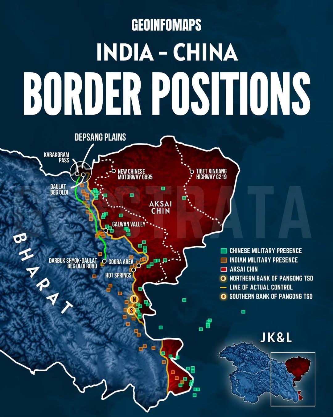
The "India-China Border Positions Map" provides a detailed outline of the complex and often contested border between India and China, highlighting the various positions, claims, and tensions that exist in this strategically important region. This visualization serves as a crucial tool for understanding the geographical and political landscape of one of the world's most significant bilateral relationships. As we delve deeper into the intricacies of this border, we can better appreciate the historical context and current dynamics that define it.
Deep Dive into the India-China Border
The India-China border, often referred to as the Line of Actual Control (LAC), extends over 3,400 kilometers across some of the most rugged terrains in the world, including the Himalayan mountain range. Interestingly, the border is not clearly demarcated, which has led to numerous skirmishes and diplomatic standoffs over the years. The complexity of this border stems from various historical treaties and conflicts, particularly the 1962 Sino-Indian War, which continues to influence relations between these two nuclear-armed neighbors.
The border can be divided into three main sectors: the western sector, which includes parts of Ladakh; the middle sector, which encompasses portions of Himachal Pradesh and Uttarakhand; and the eastern sector, primarily in Arunachal Pradesh. Each of these areas presents unique geographical features and geopolitical challenges. For instance, the western sector is characterized by high-altitude deserts, while the eastern sector boasts lush valleys and dense forests.
What's fascinating is that the border not only represents a physical divide but also embodies a clash of national identities and aspirations. The area is rich in natural resources, including water and minerals, which further complicates the situation. According to a recent study, the waters originating from the Himalayas are vital for millions of people downstream in both India and China. Therefore, control over these resources often translates into political leverage.
Moreover, the border has been the focus of military posturing by both nations, with significant troop deployments and infrastructure development in recent years. For example, India has been bolstering its defenses by constructing new roads and airstrips in border areas, while China has also been enhancing its military capabilities along the LAC. This arms buildup not only escalates tensions but also raises the stakes for any potential conflict.
Regional Analysis
When we analyze the map regionally, it’s evident that the western sector, particularly Ladakh, has seen heightened tensions in recent years. The Galwan Valley clash in June 2020 is a stark reminder of how quickly relations can deteriorate. In contrast, the middle sector remains relatively stable, though it is not without its challenges. Here, both countries have engaged in diplomatic dialogues to manage disputes peacefully.
In the eastern sector, Arunachal Pradesh is a focal point of contention, with China claiming it as part of its territory. The region is not only rich in biodiversity but also culturally diverse, hosting numerous indigenous communities. Interestingly, these communities often find themselves caught in the crossfire of nationalistic fervor and territorial claims. The varying degrees of military presence and infrastructure development across these sectors reflect the geopolitical priorities of both nations.
Significance and Impact
Understanding the India-China border positions is crucial for several reasons. First, the region is a critical flashpoint in Asian geopolitics, with implications for global stability. Any escalation between these two nuclear powers could have far-reaching consequences beyond their borders. Additionally, the ongoing tensions impact trade routes, energy security, and regional alliances, making it a topic of interest for global powers as well.
Moreover, current trends indicate that the competition for resources and strategic dominance in the region will only intensify. As climate change continues to affect water availability and natural disasters become more frequent, the stakes surrounding this border will rise. Countries in the region, and indeed the world, must pay attention to this complex relationship and its potential outcomes.
In conclusion, the India-China border positions map is not just a representation of lines on a geographical layout; it is a reflection of historical grievances, national pride, and the quest for regional dominance. As we navigate the complexities of this border, it's essential to remain informed about its implications for peace and security in Asia and beyond.
Visualization Details
- Published
- August 25, 2025
- Views
- 180
Comments
Loading comments...