European Wildfires 2025 Map

Marcus Rodriguez
Historical Geography Expert
Marcus Rodriguez specializes in historical cartography and geographic data analysis. With a background in both history and geography, he brings unique...
Geographic Analysis
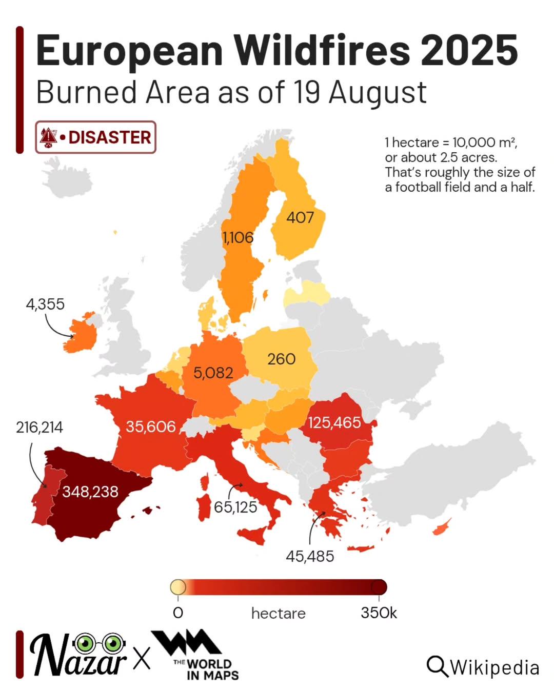
What This Map Shows
The "European Wildfires 2025 Map" provides a comprehensive visualization of projected wildfire occurrences throughout Europe. Utilizing data on climate patterns, vegetation types, and historical fire incidents, the map illustrates regions at high risk of wildfires in the upcoming year. This visualization serves as a crucial tool for understanding the potential for wildfires and their implications for both the environment and human populations.
Deep Dive into Wildfire Dynamics in Europe
Wildfires are a significant concern in Europe, driven by a combination of climate change, land management practices, and natural weather patterns. Interestingly, the Mediterranean region has long been the hotspot for wildfires, primarily due to its hot, dry summers and the presence of flammable vegetation. Countries like Greece, Spain, and Italy often experience devastating fires that can lead to loss of life, property, and biodiversity.
Recent studies indicate that climate change is exacerbating wildfire risks across Europe. Rising temperatures and prolonged drought conditions create a perfect storm for wildfires to ignite and spread. For instance, the European Environment Agency reports that the average temperature in Southern Europe has increased by 1.5 degrees Celsius over the past few decades, which is significantly above the global average. This increase correlates with a rise in wildfire incidents, making the need for effective fire management strategies even more critical.
What's fascinating is that not all regions of Europe are equally affected by wildfires. Northern European countries, such as Sweden and Finland, are generally at a lower risk due to their cooler climates and higher rainfall. However, even these areas are facing increased wildfire threats as climate patterns shift. For instance, the 2021 wildfire season in Sweden was one of the most severe in recent history, highlighting the changing dynamics of fire risks across Europe.
Moreover, the types of vegetation play a crucial role in the likelihood of wildfires. Forests laden with pine trees, for example, are particularly susceptible to fires due to the resinous nature of the trees. In contrast, deciduous forests may be less prone, but they are not immune. The map highlights the different vegetation zones across Europe, illustrating areas where wildfires might be more probable based on the type of flora present.
Regional Analysis
When examining the map closely, it's clear that Southern Europe is at the forefront of wildfire risk. Countries like Greece and Italy show high-risk zones, particularly in regions with extensive forest cover and dry conditions. For instance, the Peloponnese region in Greece has repeatedly faced significant wildfires, resulting in extensive damage to both the environment and local communities.
Conversely, Western Europe, including countries like Germany and France, shows a more varied risk profile. While rural areas may experience occasional wildfires, urban areas are generally less affected due to better firefighting resources and infrastructure. However, climate models suggest that as temperatures continue to rise, even these regions could see an increase in wildfire frequency.
Interestingly, Eastern Europe presents a different narrative. Countries like Poland and Hungary, typically not associated with significant wildfire risks, are experiencing shifts in vegetation and climate that could lead to increased fire incidents. The map indicates emerging risks in these regions, prompting local governments to reassess their fire prevention strategies.
Significance and Impact
The implications of wildfire risks in Europe are profound. Beyond the immediate threat to human life and property, wildfires have long-term ecological and economic impacts. Forest ecosystems are crucial for carbon sequestration, and large-scale fires can release significant amounts of CO2 into the atmosphere, contributing to global warming. Additionally, the destruction of habitats can lead to loss of biodiversity, affecting species that depend on these ecosystems for survival.
Moreover, the financial burden of wildfires is staggering. The European Commission estimates that wildfires cost the EU billions of euros each year in firefighting efforts, property damage, and loss of agricultural productivity. As climate change progresses, these costs are expected to rise, making it essential for governments to invest in better fire management and prevention strategies.
In conclusion, the "European Wildfires 2025 Map" not only serves as a wake-up call but also emphasizes the urgent need for proactive measures. As we move forward, understanding the ecological and socio-economic implications of wildfires will be crucial for safeguarding both our environment and communities. Have you considered how your local area might be affected by these changes? It's time we all take an interest in wildfire prevention and management strategies to protect our precious landscapes and lives.
Visualization Details
- Published
- August 23, 2025
- Views
- 188
Comments
Loading comments...