Map of Germany's Territorial Losses After World War Defeats

Marcus Rodriguez
Historical Geography Expert
Marcus Rodriguez specializes in historical cartography and geographic data analysis. With a background in both history and geography, he brings unique...
Geographic Analysis
What This Map Shows
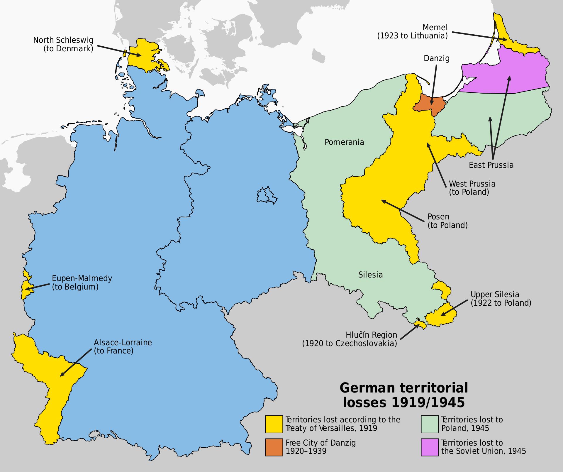
This map illustrates the significant territorial losses Germany faced following its defeats in both World War I and World War II. It delineates the regions that were ceded, highlighting the dramatic shifts in borders that reshaped not only the nation of Germany but also the broader European landscape. The visualization serves as a stark reminder of the consequences of war and the geopolitical changes that can result from conflict.
Deep Dive into Territorial Changes
The territorial losses of Germany are a crucial aspect of 20th-century history, reflecting the aftermath of two of the most devastating conflicts in human history. Following World War I, the Treaty of Versailles in 1919 imposed heavy penalties on Germany, both financially and territorially. Key regions lost included Alsace-Lorraine, which was returned to France, and large portions of land in the east, such as West Prussia and Posen, which were ceded to the newly established Poland. This shift significantly impacted Germany's demographic and economic landscape.
Interestingly, the loss of these territories was not just a matter of land but also involved a significant number of ethnic Germans who suddenly found themselves in foreign nations. For example, in the case of East Prussia, which lost its access to the Baltic Sea, the ramifications were felt economically and socially as many Germans were forced to relocate.
Fast forward to the end of World War II in 1945, and the situation became even more complex. The Potsdam Agreement led to further territorial adjustments, including the loss of territories in the east, such as Silesia, Pomerania, and parts of Brandenburg, which were transferred to Poland and the Soviet Union. This time, the changes were part of a broader effort to reshape post-war Europe and prevent future conflicts, with millions of Germans displaced in a massive population transfer.
These territorial adjustments were not merely administrative; they had profound implications for national identity and cultural heritage. The loss of regions like Silesia, where a rich German culture had thrived for centuries, left a lasting impact on the collective memory of the German people. Moreover, the new borders drawn post-World War II significantly altered trade routes, economic ties, and the geopolitical dynamics of Central and Eastern Europe.
Regional Analysis
Examining specific regions on the map reveals distinct narratives. For instance, the loss of Silesia not only involved a transfer of land but also an economic hub that had been vital for Germany's industrial strength. After the war, the Polish government nationalized many industries that had been German-owned, leading to significant economic shifts in the region.
Comparatively, the loss of territories to France, such as Alsace-Lorraine, was characterized by cultural and linguistic tensions. These regions were historically significant for Germany, and their loss was felt deeply among the German populace. The reintegration of these territories into France also fueled nationalist sentiments on both sides, contributing to a complex relationship that continues to this day.
Interestingly, the regions ceded to the Soviet Union, particularly in East Prussia, have seen significant demographic changes. The former German population was replaced by Polish settlers and Soviet citizens, leading to a complete transformation of the cultural landscape. Have you noticed how historical migrations often reshape the identity of a region?
Significance and Impact
Understanding the territorial losses of Germany post-World Wars is essential for grasping the current geopolitical landscape of Europe. These changes not only influenced national borders but also the relationships between nations, contributing to tensions that can still be felt today. The borders defined in the aftermath of these wars established the framework for the Cold War and influenced the formation of the European Union and NATO.
Moreover, the historical context of these territorial changes is crucial in understanding contemporary issues such as nationalism and regional autonomy movements. Countries that once faced territorial disputes may still grapple with the legacies of those conflicts, affecting international relations and domestic policies.
In conclusion, the map of Germany's territorial losses serves as a powerful reminder of how geography is intertwined with history. The implications of these changes are felt far beyond the borders of Germany, as they continue to influence geopolitical dynamics and national identities in the 21st century. As we reflect on these historical events, it's essential to consider how they shape our understanding of current and future conflicts in Europe and beyond.
Visualization Details
- Published
- August 22, 2025
- Views
- 204
Comments
Loading comments...